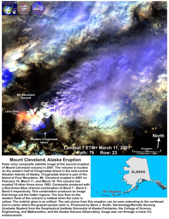
False color composite satellite image of the second eruption of Mount Cleveland volcano in 2001. The volcano is located on the western half of Chuginadak Island in the east-central Aleutian Islands of Alaska. Chuginadak Island is part of the Island of Four Mountains. Mt. Cleveland erupted in 2001 on February 19, March 11, and March 19. The volcano has erupted 16 other times since 1893. Composite produced with a Red-Green-Blue channel combination of Band 7 - Band 5 - Band 4 respectively. This combination produces an image that brings out the hotter regions. The lava flow on the western flank of the volcano is hottest when the color is yellow. The reddish glow is an artifact. The ash plume from this eruption can be seen extending to the northeast and is cooler where the grayish-purple color is. Produced by Steve J. Smith, Volcanology/Remote Sensing Graduate Student from the Geophysical Institute University of Alaska Fairbanks, the College of Science, Engineering, and Mathematics, and the Alaska Volcano Observatory. Image was run through a linear 2% enhancement.
Volcano(es): Cleveland
Photographer: Smith, S. J.
URL: avo.alaska.edu/image/view/180
Cleveland 2001/2
From Dean and others (2002): "Mt. Cleveland erupted explosively on 19 February and on 11 and 19 March 2001.
* * * "The first indication to AVO of activity at Mt. Cleveland was the 19 February eruption. However, after the eruption, AVO received reports indicating that precursory activity had taken place. Most graphic was a photograph taken on 2 February by a pilot flying by the volcano showing a dark, lobate deposit on the snow-covered southwest flank and robust steaming from the summit crater. During this same period, residents of Nikolski observed steaming at the summit and snowmelt on the flanks of the cone.
"On 19 February, Mt. Cleveland erupted explosively at approximately 1430 UT. Pilot reports indicate that the altitude of the plume increased with time from 7.5 km a few hours after the start of the eruption, and up to 12 km eight hours later. The eruption cloud and a thermal anomaly were detected on AVHRR satellite data at 1655 UTC. The plume was complex and extended in two directions, 40 km northwest and 60 km southeast of the volcano.
* * * "By 21 February (0300 UT), 35 hours after the eruption, the ash cloud was over 1000 km long and extended from Cook Inlet, Alaska, to Chukotsk Peninsula, Russia. Eventually this long, arcing cloud split into three segments that drifted north over the Arctic Ocean, over Fairbanks near the center of the state, and south into the Gulf of Alaska.
* * * "Mt. Cleveland erupted again on 11 March. This explosive eruption lasted 3 hours (1400 to 1700 UT) based on satellite observations, with an estimated cloud height of 8 km.
* * * "The 19 March eruption lasted up to 6 hours (2330-0530 UT), with an estimated cloud height of up to 9 km according to the National Weather Service.
* * * "Throughout March and April, elevated surface temperatures and low altitude ash clouds were periodically observed on satellite data. Ground and air observers noticed minor ash clouds over the volcano during the same period.
* * * "Despite the extensive area traversed by the February plume, ash fall was observed only at Nikolski over a period of approximately 5 hours on 19 February. Residents reported that the ash fall occurred under a hazy sky and consisted of a very light dusting of fine-grained material. School children in Nikolski were given paper masks to wear home and residents were advised to stay indoors. No injuries or health impacts have been reported; one resident noted that breathing outside without a mask 'made you want to cough.'
"A sample from Nikolski shows that the ash is composed of glass shards, crystals, and lithics. * * * The glass is dacitic and has a magmatic morphology rather than phreatomagmatic."
Smith (2005), estimates a total erupted volume of deposits (not including tephra) from January through late March 2001 as 1.12 x10^6 cubic meters (+/- 3.07x10^5 cubic meters).
Please cite the image author and Alaska Volcano Observatory / University of Alaska Fairbanks, Geophysical Institute when using this image.
Full Resolution.