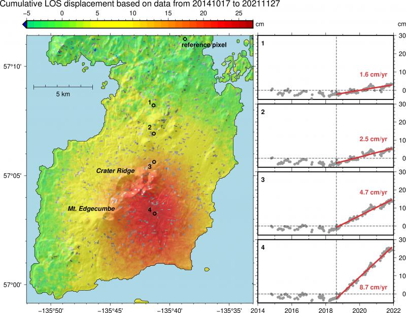
Main map: Kruzof Island with Mount Edgecumbe and Crater Ridge labeled. Cumulative displacement measured in the line of sight (LOS) of Sentinel 1 radar satellites from Nov 2014-Dec 2021 (positive LOS displacement means uplift and horizontal motion toward the satellite). All deformation is given with observations at the reference pixel removed (chosen away from volcano to only capture tectonic and glacial isostatic adjustment / uplift), resulting in predominantly volcanic motion shown. Red indicates up to 27 cm of inflation. Timeseries insets show deformation over time at locations numbered 1-4 on the main map. Vertical line shows onset of inflation in Aug 2018. We observe linear inflation of up to 8.7 cm/yr since then.
Volcano(es): Edgecumbe
Photographer: Cheng, Yitian
URL: avo.alaska.edu/image/view/182216
Edgecumbe unrest 2018
AVO issued an Information Statement on April 13, 2022, for Mount Edgecumbe, stating "A swarm of earthquakes has been detected in the vicinity of Mount Edgecumbe volcano, beginning at about 2 am AKDT on Monday, April 11, 2022. There have been hundreds of small quakes in the swarm, though the large majority are too small to locate. The National Earthquake Information Center reported that one of the largest earthquakes in the swarm occurred at 11:04 AKDT on April 11, with a magnitude of 2.8 at 10 km depth. The Alaska Earthquake Center reported another earthquake occurred at 3:44 pm AKDT on April 11, with a magnitude of 2.1 and depth of 4 km. As of this morning, the swarm continues, though the rate of earthquakes has declined over the past 24 hours.
"The cause of this earthquake swarm is currently unknown. This swarm may be associated with volcanic processes, regional tectonic activity, or a combination of sources. AVO does not have local seismic instruments in the area, and the closest station is in Sitka, 24 km (15 miles) to the east of the volcano.
"Retrospective analysis of earthquake data in the area shows that a small number of earthquakes started occurring under Edgecumbe in 2020. This week's activity is unusual in the number of events, however."
AVO issued a following information statement on Friday, April 22, 2022, stating "A swarm of earthquakes was detected in the vicinity of Mount Edgecumbe volcano beginning on Monday, April 11, 2022. There were hundreds of small quakes in the swarm, though the large majority were too small to locate. Over the past few days, earthquake activity has declined and is currently at background levels.
"The recent swarm inspired an in-depth analysis of the last 7.5 years of ground deformation detectable with radar satellite data. Analysis of these data from recent years reveals a broad area, about 17 km (10.5 miles) in diameter, of surface uplift centered about 2.5 km (1.5 miles) to the east of Mt Edgecumbe. This uplift began in August 2018 and has been continuing to the present at a rate of up to 8.7 cm/yr (3.4 in/yr) in the center of the deforming area. Deformation has been constant since 2018, and there has not been an increase with the recent earthquake activity. The total deformation since 2018 is about 27 cm (10.6 inches). A figure showing the deformation can be seen here: http://www.avo.alaska.edu/images/image.php?id=182216
"Retrospective analysis of earthquake data in the area of Mount Edgecumbe shows that a small number of earthquakes started occurring under the volcano in 2020. The recent earthquake activity that started on April 11 was unusual in having a greater number of events, however. The earthquakes detected under the volcano since 2020 are all M3.0 or smaller. Note that only the largest of the earthquakes can be located by regional seismic networks; hundreds of very small additional events have been detected, but not located. A map showing earthquake locations in the area, including those occurring on regional faults, can be found here: http://www.avo.alaska.edu/images/image.php?id=182214
"There have been no visual changes, surface temperature changes, or gas emissions observed.
"The coincidence of earthquakes and ground deformation in time and location suggests that these signals are likely due to the movement of magma beneath Mount Edgecumbe, as opposed to tectonic activity. Initial modeling of the deformation signal shows that it is consistent with an intrusion of new material (magma) at about 5 km (3.1 miles) below sea level. The earthquakes likely are caused by stresses in the crust due to this intrusion and the substantial uplift that it is causing.
"Intrusions of new magma under volcanoes do not always result in volcanic eruptions. The deformation and earthquake activity at Edgecumbe may cease with no eruption occurring. If the magma rises closer to the surface, this would lead to changes in the deformation pattern and an increase in earthquake activity. Therefore, it is very likely that if an eruption were to occur it would be preceded by additional signals that would allow advance warning.
"There is no local volcano monitoring network at Edgecumbe. The closest seismic station is in Sitka, 24 km (15 miles) to the east of the volcano and is operated by the National Tsunami Warning Center. Updated satellite radar observations become available on weekly timescales.
"AVO has begun plans to add to current monitoring capabilities, possibly by adding instruments closer to the volcano. In the meantime, we are monitoring Edgecumbe using existing regional seismic stations and satellite data."
Please cite the photographer and the Alaska Volcano Observatory / University of Alaska Fairbanks, Geophysical Institute when using this image.
Full Resolution.