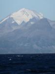
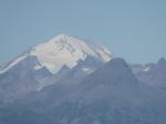
Chiginagak
Spurr
Great Sitkin
Akutan
Aniakchak
Atka volcanic complex
Augustine
Cleveland
Dutton
Edgecumbe
Fisher
Gareloi
Great Sitkin
Griggs
Iliamna
Isanotski
Kanaga
Katmai
Little Sitkin
Mageik
Makushin
Martin
Novarupta
Pavlof
Redoubt
Semisopochnoi
Shishaldin
Snowy
Spurr
Takawangha
Tanaga
Trident
Ugashik-Peulik
Ukinrek Maars
Veniaminof
Westdahl
Wrangell
Adagdak
Addington volcanic field
Alagogshak
Amak
Amchixtam Chaxsxii
Amukta
Andrew Bay volcano
Basalt of Gertrude Creek
Behm Canal-Rudyerd Bay
Black Peak
Blue Mtn
Bobrof
Bogoslof
Buldir
Buzzard Creek
Camille Cone
Capital
Carlisle
Chagulak
Chiginagak
Churchill, Mt
Cone 3110
Cone 3601
Dana
Davidof
Denison
Devils Desk
Double Glacier
Douglas
Drum
Duncan Canal
Emmons Lake Volcanic Center
Espenberg
Folsoms Bluff
Fourpeaked
Frosty
Gas Rocks, the
Gilbert
Gordon
Gosling Cone
Hayes
Herbert
Imuruk Lake Volc Field
Ingakslugwat Hills
Ingenstrem Depression Volcanic Field
Ingrisarak Mtn
Iron Trig cone
Iskut-Unuk River cones
Jarvis
Jumbo Dome
Kagamil
Kaguyak
Kasatochi
Kejulik
Kialagvik
Kiska
Klawasi Group
Knob 1000
Kochilagok Hill
Koniuji
Kookooligit Mountains
Koyuk-Buckland volcanics
Kukak
Kupreanof
Lone basalt
Maclaren River volcanic field
Moffett
Monogenetic QT vents of WWVF
Morzhovoi
Nelson Island
Nunivak Island
Nushkolik Mountain volcanic field
Okmok
Pavlof Sister
Prindle Volcano
Rainbow River cone
Recheshnoi
Roundtop
Sanford
Seguam
Segula
Sergief
Skookum Creek
St. George volcanic field
St. Michael
St. Paul Island
Steller
Stepovak Bay 1
Stepovak Bay 2
Stepovak Bay 3
Stepovak Bay 4
Suemez Island
Table Top Mtn
Tanada Peak
Tanax̂ Angunax̂
Tlevak Strait
Togiak volcanics
Trader Mtn
Uliaga
Ungulungwak Hill-Ingrichuak Hill
Unimak 5270
Unnamed (near Ukinrek Maars)
Vsevidof
Western Cones
Wide Bay cone
Yantarni
Yunaska
Legend
✕
| Red (Warning) | |
| Orange (Watch) | |
| Yellow (Advisory) | |
| Green (Normal) | |
| Uninstrumented | |
| Community | |
| Webcam | |
| Instrument | |
| Earthquake Magnitude | |
|
0
| |
| Earthquake Age | |
| Last 2 Hours | |
| Last 2 Days | |
| Last 1 Week | |
Facts
- Official Name: Mount Chiginagak
- Seismically Monitored: No
- Color Code: UNASSIGNED
- Alert Level: UNASSIGNED
- Elevation: 2108m (6916ft)
- Latitude: 57.13348
- Longitude: -156.99147
- Smithsonian VNum: 312110
-
Nearby Towns:
- Ugashik 30 mi (49 km) NW
- Pilot Point 37 mi (59 km) NW
- Kanatak 47 mi (75 km) NE
- Port Heiden 63 mi (101 km) SW
- Egegik 76 mi (122 km) NW
Distance from Anchorage: 377 mi (607 km)
Description
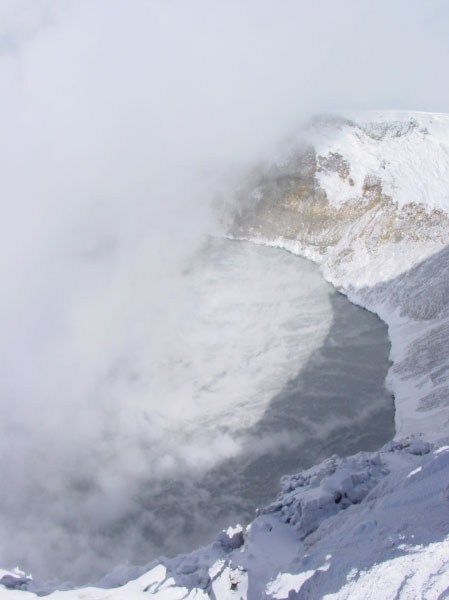
From Miller and others (1998) [1] : "Chiginagak volcano is a symmetric composite cone about 8 km in diameter built on late Tertiary volcanic rocks and Jurassic-Cretaceous sedimentary rocks and located on a southwest trending regional anticline [2] . A deep breach on the south flank on the volcano extends to a small summit crater and exposes widespread alteration of interbedded lava flows and breccias near the summit of the volcano. Snow and ice cover much of the uppermost 1000 m of the cone."Monolithologic breccias (vb) low on the west side of the volcano represent at least two early periods of dome growth and collapse, separated by a period of lava extrusion. The undissected form of the cone is the result of the eruption of andesitic lava flows and pyroclastic rocks (vu) following the emplacement of the youngest breccias. Somewhat younger andesite and dacite flows occur on the west flank and basalt flows (some as young as Holocene) occur on the eastern flank of the volcano. Satellitic dacite (?) domes of Holocene age occur high on the east and west flanks, the most recently active of which is the eastern dome which was the source of thin pyroclastic or epiclastic deposits (ba) that overlie nonglaciated basaltic lava flows."
Name Origin
Mount Chiginagak's name was first published in 1888 by the U.S. Bureau of Fisheries (Orth, 1971).
References Cited
[1] Catalog of the historically active volcanoes of Alaska, 1998
Miller, T. P., McGimsey, R. G., Richter, D. H., Riehle, J. R., Nye, C. J., Yount, M. E., and Dumoulin, J. A., 1998, Catalog of the historically active volcanoes of Alaska: U.S. Geological Survey Open-File Report 98-0582, 104 p.[2] Generalized geologic map of the Ugashik, Bristol Bay, and part of the Karluk quadrangles, Alaska, 1983
Detterman, R. L., Case, J. E., Wilson, F. H., Yount, M. E., and Allaway, W. H. Jr., 1983, Generalized geologic map of the Ugashik, Bristol Bay, and part of the Karluk quadrangles, Alaska: U.S. Geological Survey Miscellaneous Field Studies Map MF 1539-A, unpaged, 1 sheet, scale 1:250,000.Reported Activity
Modern Eruptions
7 Event Date(s)
Past Activity Legend:
| Eruption | |
| Questionable eruption | |
| Non-eruptive activity |


Map Images
By:
Schaefer, J. R. G.
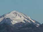
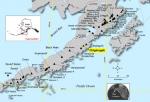
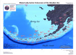
Location of Chiginagak volcano and nearby volcanoes on the Alaska Peninsula.
Location of Chiginagak volcano and nearby volcanoes on the Alaska Peninsula.
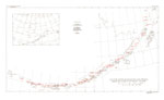
By:
U.S. Geological Survey
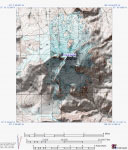
Topographic shaded relief map of Chiginagak Volcano, Alaska.
Topographic shaded relief map of Chiginagak Volcano, Alaska.
By:
U.S. Geological Survey
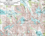
Topographic map of Chiginagak and Kialagvik.
Topographic map of Chiginagak and Kialagvik.
By:
Schaefer, J. R. G.
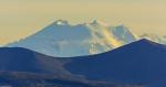
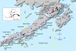
Alaska Peninsula volcanoes.
Alaska Peninsula volcanoes.

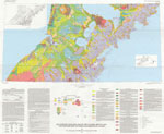
By:
Schaefer, Janet
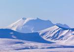
Index map showing the location of Quaternary volcanoes on the Alaska peninsula.
Index map showing the location of Quaternary volcanoes on the Alaska peninsula.
Map References
Recently active volcanoes of Alaska, 2023
Cameron, C.E., Bull, K.F., and Macpherson, A.E., 2023, Recently active volcanoes of Alaska: Alaska Division of Geological & Geophysical Surveys Miscellaneous Publication 133 v. 6, 2 sheets. https://doi.org/10.14509/31086.
Historically active volcanoes of Alaska, v. 3, 2018
Cameron, C.E., Schaefer, J.R., and Mulliken, K.M., 2018, Historically active volcanoes of Alaska: Alaska Division of Geological & Geophysical Surveys Miscellaneous Publication 133 v. 3, 2 sheets. Http://doi.org/10.14509/30142
Geologic map of Mount Chiginagak volcano, Alaska, 2017
Schaefer, J.R., Scott, W.E., and Layer, P.W., 2017, Geologic map of Mount Chiginagak volcano, Alaska: Alaska Division of Geological & Geophysical Surveys Report of Investigation 2017-10, 32 p., 1 sheet, scale 1:25,000. http://doi.org/10.14509/29769
Historically active volcanoes of Alaska, 2014
Schaefer, J.R., Cameron, C.E., and Nye, C.J., 2014, Historically active volcanoes of Alaska: Alaska Division of Geological & Geophysical Surveys Miscellaneous Publication 133 v. 1.2, 1 sheet, scale 1:3,000,000.
This publication has been superseded. Newest version available at http://www.dggs.alaska.gov/pubs/id/20181 .
Preliminary bathymetric map of Mother Goose Lake, Alaska Peninsula, 2008
Schaefer, J.R., Wallace, K.L., and Kassel, C.M., 2008, Preliminary bathymetric map of Mother Goose Lake, Alaska Peninsula: Alaska Division of Geological & Geophysical Surveys Raw Data File 2008-3, 1 disc, available at http://www.dggs.dnr.state.ak.us/pubs/id/16301 .
Historically active volcanoes of the Aleutian Arc, 2002
Schaefer, Janet, and Nye, C. J., 2002, Historically active volcanoes of the Aleutian Arc: Alaska Division of Geological & Geophysical Surveys Miscellaneous Publication MP 0123, unpaged, 1 sheet, scale 1:3,000,000. Superceded by Miscellaneous Publication 133: http://www.dggs.dnr.state.ak.us/pubs/pubs?reqtype=citation&ID=20181
Volcanoes of Alaska, 1998
Nye, C. J., Queen, Katherine, and McCarthy, A. M., 1998, Volcanoes of Alaska: Alaska Division of Geological & Geophysical Surveys Information Circular IC 0038, unpaged, 1 sheet, scale 1:4,000,000, available at http://www.dggs.dnr.state.ak.us/pubs/pubs?reqtype=citation&ID=7043 .

Volcanoes of Alaska, 1995
Alaska Division of Geological & Geophysical Surveys, 1995, Volcanoes of Alaska: Alaska Division of Geological & Geophysical Surveys Information Circular IC 0038, unpaged, 1 sheet, scale 1:4,000,000.
Geothermal resources of the Aleutian Arc, 1993
Motyka, R. J., Liss, S. A., Nye, C. J., and Moorman, M. A., 1993, Geothermal resources of the Aleutian Arc: Alaska Division of Geological & Geophysical Surveys Professional Report PR 0114, 17 p., 4 sheets, scale 1:1,000,000.

Holocene volcanoes of the Aleutian Arc, Alaska, 1993
March, G. D., 1993, Holocene volcanoes of the Aleutian Arc, Alaska: Alaska Division of Geological & Geophysical Surveys Public-Data File PDF 93-85, unpaged, 1 sheet, scale 1:2,000,000.
Mineral and energy resource assessment maps of the Ugashik, Bristol Bay and western Karluk quadrangles, Alaska, 1989
Church, S. E., Detterman, R. L., and Wilson, F. H., 1989, Mineral and energy resource assessment maps of the Ugashik, Bristol Bay and western Karluk quadrangles, Alaska: U.S. Geological Survey Miscellaneous Field Studies Map MF 1539-I, unpaged, 2 plates, scale 1:63,360.
Maps showing aeromagnetic survey and geologic interpretation of the Ugashik and part of the Karluk quadrangles, Alaska, 1988
Case, J. E., Detterman, R. L., Wilson, F. H., Chuchel, B. A., and Yount, M. E., 1988, Maps showing aeromagnetic survey and geologic interpretation of the Ugashik and part of the Karluk quadrangles, Alaska: U.S. Geological Survey Miscellaneous Field Studies Map MF 1539-D, 12 p., 2 plates, scale 1:250,000.
Quaternary geologic map of the Ugashik, Bristol Bay, and western part of Karluk quadrangles, Alaska, 1987
Detterman, R. L., Wilson, F. H., Yount, M. E., and Miller, T. P., 1987, Quaternary geologic map of the Ugashik, Bristol Bay, and western part of Karluk quadrangles, Alaska: U.S. Geological Survey Miscellaneous Investigations Series Map I 1801, unpaged, 1 sheet, scale 1:250,000, available online at http://www.dggs.dnr.state.ak.us/pubs/pubs?reqtype=citation&ID=12928 .
Geologic map of the Ugashik, Bristol Bay, and western part of Karluk quadrangle, Alaska, 1987
Detterman, R. L., Case, J. E., Wilson, F. H., and Yount, M. E., 1987, Geologic map of the Ugashik, Bristol Bay, and western part of Karluk quadrangle, Alaska: U.S. Geological Survey Miscellaneous Investigations Series Map I 1685, unpaged, 1 plate, scale 1:250,000.
Map showing distribution, composition, and age of Late Cenozoic volcanic centers in Alaska, 1986
Luedke, R. G., and Smith, R. L., 1986, Map showing distribution, composition, and age of Late Cenozoic volcanic centers in Alaska: U.S. Geological Survey Miscellaneous Investigations Series Map I 1091-F, unpaged, 3 sheets, scale 1:1,000,000.
Generalized geologic map of the Ugashik, Bristol Bay, and part of the Karluk quadrangles, Alaska, 1983
Detterman, R. L., Case, J. E., Wilson, F. H., Yount, M. E., and Allaway, W. H. Jr., 1983, Generalized geologic map of the Ugashik, Bristol Bay, and part of the Karluk quadrangles, Alaska: U.S. Geological Survey Miscellaneous Field Studies Map MF 1539-A, unpaged, 1 sheet, scale 1:250,000.
Preliminary maps showing interpretation of Landsat imagery of the Ugashik and Karluk quadrangles, Alaska, 1981
LeCompte, J. R., 1981, Preliminary maps showing interpretation of Landsat imagery of the Ugashik and Karluk quadrangles, Alaska: U.S. Geological Survey Open-File Report 81-0776, unpaged, 2 plates, scale 1:250,000.
Volcanic activity in the Aleutian Arc, 1950
Coats, R. R., 1950, Volcanic activity in the Aleutian Arc: U.S. Geological Survey Bulletin 0974-B, p. 35-49, 1 sheet, scale 1:5,000,000.
The Cold Bay-Chignik District, Alaska, 1924
Smith, W. R., and Baker, A. A., 1924, The Cold Bay-Chignik District, Alaska: U.S. Geological Survey Bulletin 0755-D, p. 151-222, 5 plates, scale 4 at 1:250,000 and 1 unknown.

References
Proximity to active volcanoes enhances glacier velocity, 2024
Mallalieu, J., Barr, I.D., Spagnolo, M., Mullan, D.J., Symeonakis, E., Edwards, B.R., and Martin, M.D., 2024, Proximity to active volcanoes enhances glacier velocity: Communications Earth & Environment v. 5, 679. https://doi.org/10.1038/s43247-024-01826-5
Recently active volcanoes of Alaska, 2023
Cameron, C.E., Bull, K.F., and Macpherson, A.E., 2023, Recently active volcanoes of Alaska: Alaska Division of Geological & Geophysical Surveys Miscellaneous Publication 133 v. 6, 2 sheets. https://doi.org/10.14509/31086.
Alaska interagency operating plan for volcanic ash episodes, 2022
Alaska Volcano Observatory, National Oceanic and Atmospheric Administration, National Weather Service, Federal Aviation Administration, Department of Defense, United States Coast Guard, Division of Homeland Security and Emergency Management, Alaska Department of Environmental Conservation, and Alaska Department of Health and Social Services (participating agencies), 2022, Alaska interagency operating plan for volcanic ash episodes, 85 p.

Selected crater and small caldera lakes in Alaska: Characteristics and hazards, 2022
Waythomas, C.F., 2022, Selected crater and small caldera lakes in Alaska: Characteristics and hazards: Frontiers in Earth Science, v. 9, p. 23, doi:10.3389/feart.2021.751216.
Geologic database of information on volcanoes in Alaska (GeoDIVA), 2022
Cameron, C.E., Crass, S.W., and AVO Staff, eds, 2022, Geologic database of information on volcanoes in Alaska (GeoDIVA): Alaska Division of Geologic and Geophysical Surveys Digital Data Series 20, https://doi.org/10.14509/geodiva, https://doi.org/10.14509/30901.
Quantifying eruptive and background seismicity, deformation, degassing, and thermal emissions at volcanoes in the United States during 1978-2020, 2021
Reath, K., Pritchard, M.E., Roman, D.C., Lopez, T., Carn, S., Fischer, T.P., Lu, Z., Poland, M.P., Vaughan, R.G., Wessels, R., Wike, L.L., and Tran, H.K., 2021, Quantifying eruptive and background seismicity, deformation, degassing, and thermal emissions at volcanoes in the United States during 1978-2020: Journal of Geophysical Research: Solid Earth, v. 126, e2021JB021684, doi: 10.1029/2021JB021684.
Historically active volcanoes of Alaska, v. 4, 2020
Cameron, C.E., Schaefer, J.R., and Ekberg, P.G., 2020, Historically active volcanoes of Alaska: Alaska Division of Geological & Geophysical Surveys Miscellaneous Publication 133 v. 4, 2 sheets. Http://doi.org/10.14509/30426
2018 update to the U.S. Geological Survey national volcanic threat assessment, 2018
Ewert, J.W., Diefenbach, A.K., and Ramsey, D.W., 2018, 2018 update to the U.S. Geological Survey national volcanic threat assessment: U.S. Geological Survey Scientific Investigations Report 2018-5140, 40 p., https://pubs.usgs.gov/sir/2018/5140/sir20185140.pdf.
Historically active volcanoes of Alaska, v. 3, 2018
Cameron, C.E., Schaefer, J.R., and Mulliken, K.M., 2018, Historically active volcanoes of Alaska: Alaska Division of Geological & Geophysical Surveys Miscellaneous Publication 133 v. 3, 2 sheets. Http://doi.org/10.14509/30142
Volcanic impacts on modern glaciers: a global synthesis, 2018
Barr, I.D., Lynch, C.M., Mullan, Donal, De Siena, Luca, and Spagnolo, Matteo, 2018, Volcanic impacts on modern glaciers: a global synthesis: Earth-Science Reviews, v. 182, p. 186-203, doi: http://dx.doi.org/10.1016/j.earscirev.2018.04.008.
2014 Volcanic activity in Alaska - Summary of events and response of the Alaska Volcano Observatory, 2017
Cameron, C.E., Dixon, J.P., Neal, C.A., Waythomas, C.F., Schaefer, J.R., and McGimsey, R.G., 2017, 2014 Volcanic activity in Alaska - Summary of events and response of the Alaska Volcano Observatory: U.S. Geological Survey Scientific Investigations Report 2017-5077, 81 p., https://doi.org/10.3133/sir20175077.
Geologic map of Mount Chiginagak volcano, Alaska, 2017
Schaefer, J.R., Scott, W.E., and Layer, P.W., 2017, Geologic map of Mount Chiginagak volcano, Alaska: Alaska Division of Geological & Geophysical Surveys Report of Investigation 2017-10, 32 p., 1 sheet, scale 1:25,000. http://doi.org/10.14509/29769
Historically active volcanoes of Alaska, 2016
Cameron, C.E., and Schaefer, J.R., 2016, Historically active volcanoes of Alaska: Alaska Division of Geological & Geophysical Surveys Miscellaneous Publication 133 v. 2, 1 sheet, scale 1:3,000,000. http://doi.org/10.14509/20181
Alaska Volcano Observatory image database, 2016
Cameron, C.E., and Snedigar, S.F., 2016, Alaska Volcano Observatory image database: Alaska Division of Geological & Geophysical Surveys Digital Data Series 13, https://www.avo.alaska.edu/images/. https://doi.org/10.14509/29689.
Aleutian arc geothermal fluids: chemical analyses of waters and gases, 2015
Evans, W.C., Bergfeld, D., Neal, C.A., McGimsey, R.G., Werner, C.A., Waythomas, C.F., Lewicki, J.L., Lopez, T., Mangan, M.T., Miller, T.P., Diefenbach, A., Schaefer, J., Coombs, M.L., Wang, B., Nicolaysen, K., Izbekov, P., Maharrey, Z., Huebner, M., Hunt, A.G., Fitzpatrick, J., and Freeburg, G., 2015, Aleutian Arc geothermal fluids: chemical analyses of waters and gases: U.S. Geological Survey Data release, http://dx.doi.org/10.5066/F74X55VB
Historically active volcanoes of Alaska, 2014
Schaefer, J.R., Cameron, C.E., and Nye, C.J., 2014, Historically active volcanoes of Alaska: Alaska Division of Geological & Geophysical Surveys Miscellaneous Publication 133 v. 1.2, 1 sheet, scale 1:3,000,000.
This publication has been superseded. Newest version available at http://www.dggs.alaska.gov/pubs/id/20181 .
Preliminary database of Quaternary vents in Alaska, 2014
Cameron, C.E., and Nye, C.J., 2014, Preliminary database of Quaternary vents in Alaska: Alaska Division of Geological & Geophysical Surveys Miscellaneous Publication 153, 11 p., doi:10.14509/27357 .
InSAR imaging of Aleutian volcanoes, 2014
Lu, Zhong, and Dzurisin, Daniel, 2014, InSAR imaging of Aleutian volcanoes: Chichester, UK, Springer-Praxis, 390 p.
Summit crater lake observations, and the location, chemistry, and pH of water samples near Mount Chiginagak volcano, Alaska: 2004-2012, 2013
Schaefer, J.R., Scott, W.E., Evans, W.C., Wang, Bronwen, and McGimsey, R.G., 2013, Summit crater lake observations, and the location, chemistry, and pH of water samples near Mount Chiginagak volcano, Alaska: 2004-2012: Alaska Division of Geological & Geophysical Surveys Report of Investigation 2011-6 v. 2, 25 p., available online at www.dggs.gov/pubs/id/25602 .
Written communication, 2012
Schaefer, J.R., 2012, written communication.
Volcanoes of the world [3rd edition], 2010
Siebert, L., Simkim, T., and Kimberley, P., 2010, Volcanoes of the World [3rd edition]: Berkeley, University of California Press, 564 p.
Chronology and references of volcanic eruptions and selected unrest in the United States, 1980-2008, 2009
Diefenbach, A.K., Guffanti, Marianne, and Ewert, J.W., 2009, Chronology and references of volcanic eruptions and selected unrest in the United States, 1980-2008: U.S. Geological Survey Open-File Report 2009-1118, 85 p., available at http://pubs.usgs.gov/of/2009/1118/ .
Preliminary spreadsheet of eruption source parameters for volcanoes of the world, 2009
Mastin, L.G., Guffanti, Marianne, Ewert, J.E., and Spiegel, Jessica, 2009, Preliminary spreadsheet of eruption source parameters for volcanoes of the world: U.S. Geological Survey Open-File Report 2009-1133, v. 1.2, 25 p., available at http://pubs.usgs.gov/of/2009/1133/ .
2000 years on the King Salmon River: an archaeological report for UGA-052, 2009
Biddle, K.G., and Meinhardt, R., 2009, 2000 years on the King Salmon River: an archaeological report for UGA-052: Bureau of Indian Affairs Occasional papers in Alaskan field archeology 2, 130 p.
Lacustrine evidence from Mother Goose Lake of Holocene geothermal activity at Mount Chiginagak, Alaska Peninsula, 2009
Kassel, C.M., 2009, Lacustrine evidence from Mother Goose Lake of Holocene geothermal activity at Mount Chiginagak, Alaska Peninsula: Northern Arizona University unpublished M.S. thesis, 138 p.

Historically active volcanoes of Alaska reference deck, 2009
Snedigar, S.F., and Cameron, C.C., 2009, Historically active volcanoes of Alaska reference deck: Alaska Division of Geological & Geophysical Surveys Information Circular 59, 52 p, available to order from http://www.dggs.dnr.state.ak.us/pubs/pubs?reqtype=citation&ID=20401 .
2005 Volcanic activity in Alaska, Kamchatka, and the Kurile Islands: Summary of events and response of the Alaska Volcano Observatory, 2008
McGimsey, R.G., Neal, C.A., Dixon, J.P., and Ushakov, Sergey, 2008, 2005 Volcanic activity in Alaska, Kamchatka, and the Kurile Islands: Summary of events and response of the Alaska Volcano Observatory: U.S. Geological Survey Scientific Investigations Report 2007-5269, 94 p., available at http://pubs.usgs.gov/sir/2007/5269/ .
The Alaska Volcano Observatory - 20 years of volcano research, monitoring, and eruption response, 2008
Schaefer, J.R., and Nye, Chris, 2008, The Alaska Volcano Observatory - 20 years of volcano research, monitoring, and eruption response: Alaska Division of Geological & Geophysical Surveys, Alaska GeoSurvey News, NL 2008-001, v. 11, n. 1, p. 1-9, available at http://wwwdggs.dnr.state.ak.us/pubs/pubs?reqtype=citation&ID=16061 .
20th anniversary of the Alaska Volcano Observatory, 2008
University of Alaska Fairbanks Geophysical Institute, 2008, 20th anniversary of the Alaska Volcano Observatory: University of Alaska Geophysical Institute pamphlet, 2 p.

Preliminary bathymetric map of Mother Goose Lake, Alaska Peninsula, 2008
Schaefer, J.R., Wallace, K.L., and Kassel, C.M., 2008, Preliminary bathymetric map of Mother Goose Lake, Alaska Peninsula: Alaska Division of Geological & Geophysical Surveys Raw Data File 2008-3, 1 disc, available at http://www.dggs.dnr.state.ak.us/pubs/id/16301 .
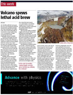
Volcano spews lethal acid brew, 2008
Giles, Jim, 2008, Volcano spews lethal acid brew: New Scientist, v. 199, n. 2664, p. 14.
The 2005 catastrophic acid crater lake drainage, lahar, and acidic aerosol formation at Mount Chiginagak volcano, Alaska, USA: Field observations and preliminary water and vegetation chemistry results, 2008
Schaefer, J. R., W. E. Scott, W. C. Evans, J. Jorgenson, R. G. McGimsey, and B. Wang, 2008, The 2005 catastrophic acid crater lake drainage, lahar, and acidic aerosol formation at Mount Chiginagak volcano, Alaska, USA: Field observations and preliminary water and vegetation chemistry results: Geochemistry Geophysics Geosystems, v. 9, n. 7, 29 p., Q07018, doi:10.1029/2007GC001900.

Natural hazards, fish habitat, and fishing communities in Alaska, 2008
Zimmerman, C.E., Neal, C.A., and Haeussler, P.J., 2008, Natural hazards, fish habitat, and fishing communities in Alaska: American Fisheries Society Symposium, v. 64, p. 375-388.
Modeling the phytotoxic dense gas flow released during the crater lake breakout of Chiginagak Volcano, 2008
Pfeffer, M., Schaefer, J., 2008. Modeling the phytotoxic gas flow released during the crater lake breakout of Chiginagak Volcano [abs.]: IAVCEI 2008 Abstracts, August 17-22, Reykjavik, Iceland, p. 71.
Instrumentation recommendations for volcano monitoring at U.S. volcanoes under the National Volcano Early Warning System, 2008
Moran, S.C., Freymueller, J.T., LaHusen, R.G., McGee, K.A., Poland, M.P., Power, J.A., Schmidt, D.A., Schneider, D.J., Stephens, G., Werner, C.A., and White, R.A., 2008, Instrumentation recommendations for volcano monitoring at U.S. volcanoes under the National Volcano Early Warning System: U.S. Geological Survey Scientific Investigations Report 2008-5114, 47 p., available online at http://pubs.usgs.gov/sir/2008/5114/ .
A phytotoxic dense gas flow produced during the crater lake breakout at Chiginagak Volcano, Alaska, 2008
Pfeffer, Melissa, and Schaefer, Janet, 2008, A phytotoxic dense gas flow produced during the crater lake breakout at Chiginagak Volcano, Alaska [abs.]: 33rd International Geological Congress, Oslo, Norway.
System for ranking relative threats of U.S. volcanoes, 2007
Ewert, John, 2007, System for ranking relative threats of U.S. volcanoes: Natural Hazards Review, v. 8, n. 4, p. 112-124.

The 2005 crater lake formation, lahar, acidic flood, and caustic aerosol and gas release from Chiginagak Volcano, Alaska, 2006
Schaefer, J.R., Scott, W.E., McGimsey, R.G., and Jorgenson, Janet, 2006, The 2005 crater lake formation, lahar, acidic flood, and caustic aerosol and gas release from Chiginagak Volcano, Alaska [abs.]:
Geological Society of America - Abstracts with Programs, v. 38, n. 5, p. 29.
Hard Copy held by AVO at FBKS - CEC shelf
Catalog of earthquake hypocenters at Alaskan volcanoes: January 1 through December 31, 2005, 2006
Dixon, J.P., Stihler, S.D., Power, J.A., Tytgat, Guy, Estes, Steve, and McNutt, S.R., 2006, Catalog of earthquake hypocenters at Alaskan volcanoes: January 1 through December 31, 2005: U.S. Geological Survey Open-File Report 2006-1264, 78 p., available at http://pubs.usgs.gov/of/2006/1264/ .
The National Volcano Early Warning System (NVEWS), 2006
Ewert, John, Guffanti, Marianne, Cervelli, Peter, and Quick, James, 2006, The National Volcano Early Warning System (NVEWS): U.S. Geological Survey Fact Sheet FS 2006-3142, 2 p., available at http://pubs.usgs.gov/fs/2006/3142 .
An assessment of volcanic threat and monitoring capabilities in the United States: framework for a National Volcano Early Warning System NVEWS, 2005
Ewert, J.W., Guffanti, Marianne, and Murray, T.L., 2005, An assessment of volcanic threat and monitoring capabilities in the United States: framework for a National Volcano Early Warning System NVEWS: U.S. Geological Survey Open-File Report 2005-1164, 62 p.

Volcanic overflow ruins summer salmon return, 2005
O'Harra, Doug, 2005, Volcanic overflow ruins summer salmon return: Anchorage Daily News, September 12, 2005, p. A1 and A8, http://www.adn.com/news/alaska/story/6960082p-6860040c.html.
July-August 2005, 2005
Alaska Volcano Observatory, 2005, July-August 2005: Alaska Volcano Observatory Bimonthly report, v. 17, n. 4, unpaged, http://www.avo.alaska.edu/avobm/introduction.php?volume=17&number=4.
The 2005 crater lake formation, lahar, acidic flood, and gas emission from Chiginagak volcano, Alaska, 2005
Schaefer, J.R., Scott, W.E., McGimsey, R.G., Jorgenson, Janet, 2005, The 2005 crater lake formation, lahar, acidic flood, and gas emission from Chiginagak volcano, Alaska, [abs.]: EOS, Transactions of the American Geophysical Union Fall Meeting Supplement, Abstract V21E-0675.
2000 Volcanic activity in Alaska and Kamchatka: Summary of events and response of the Alaska Volcano Observatory, 2004
Neal, C. A., McGimsey, R. G., and Chubarova, Olga, 2004: 2000 Volcanic activity in Alaska and Kamchatka: Summary of events and response of the Alaska Volcano Observatory: U.S. Geological Survey Open-File Report 2004-1034, 37 p.
Volcanoes of the world: an illustrated catalog of Holocene volcanoes and their eruptions, 2003
Siebert, L., and Simkin, T., 2002-, Volcanoes of the world: an illustrated catalog of Holocene volcanoes and their eruptions: Smithsonian Institution, Global Volcanism Program Digital Information Series GVP-3, http://volcano.si.edu/search_volcano.cfm, unpaged internet resource.
Bibliography of information on Alaska volcanoes, 2003
Cameron, C. E., Triplehorn, J. H., and Robar, C. L., 2003, Bibliography of information on Alaska volcanoes: Alaska Division of Geological & Geophysical Surveys Miscellaneous Publication MP 131, 1 CD-ROM.
Hard Copy held by AVO at FBKS - CEC file cabinet
1998 volcanic activity in Alaska and Kamchatka: Summary of events and response of the Alaska Volcano Observatory, 2003
McGimsey, R. G., Neal, C. A., and Girina, Olga, 2003, 1998 volcanic activity in Alaska and Kamchatka: Summary of events and response of the Alaska Volcano Observatory: U.S. Geological Survey Open-File Report 03-0423, 35 p.

Historically active volcanoes of the Aleutian Arc, 2002
Schaefer, Janet, and Nye, C. J., 2002, Historically active volcanoes of the Aleutian Arc: Alaska Division of Geological & Geophysical Surveys Miscellaneous Publication MP 0123, unpaged, 1 sheet, scale 1:3,000,000. Superceded by Miscellaneous Publication 133: http://www.dggs.dnr.state.ak.us/pubs/pubs?reqtype=citation&ID=20181
Historically active volcanoes in Alaska, a quick reference, 2000
Wallace, K. L., McGimsey, R. G., and Miller, T. P., 2000, Historically active volcanoes in Alaska, a quick reference: U.S. Geological Survey Fact Sheet FS 0118-00, 2 p.

Chiginagak, Alaska, 2000
Wood, Chuck, 2000, Chiginagak, Alaska: unpaged internet resource: http://volcano.und.edu/vwdocs/current%5Fvolcs/chiginagak/.
Encyclopedia of volcanoes, 2000
Sigurdsson, Haraldur, (ed.), 2000, Encyclopedia of volcanoes: San Diego, CA, Academic Press, 1417 p.

Data on Holocene tephra (volcanic ash) deposits in the Alaska Peninsula and lower Cook Inlet region of the Aleutian volcanic arc, Alaska, 1999
Riehle, J. R., Meyer, C. E., and Miyaoka, R. T., 1999, Data on Holocene tephra (volcanic ash) deposits in the Alaska Peninsula and lower Cook Inlet region of the Aleutian volcanic arc, Alaska: U.S. Geological Survey Open-File Report 99-0135, 5 p.
1997 volcanic activity in Alaska and Kamchatka: Summary of events and response of the Alaska Volcano Observatory, 1999
McGimsey, R. G., and Wallace, K. L., 1999, 1997 volcanic activity in Alaska and Kamchatka: Summary of events and response of the Alaska Volcano Observatory: U.S. Geological Survey Open-File Report 99-0448, 42 p.

Volcanoes of Alaska, 1998
Nye, C. J., Queen, Katherine, and McCarthy, A. M., 1998, Volcanoes of Alaska: Alaska Division of Geological & Geophysical Surveys Information Circular IC 0038, unpaged, 1 sheet, scale 1:4,000,000, available at http://www.dggs.dnr.state.ak.us/pubs/pubs?reqtype=citation&ID=7043 .
Catalog of the historically active volcanoes of Alaska, 1998
Miller, T. P., McGimsey, R. G., Richter, D. H., Riehle, J. R., Nye, C. J., Yount, M. E., and Dumoulin, J. A., 1998, Catalog of the historically active volcanoes of Alaska: U.S. Geological Survey Open-File Report 98-0582, 104 p.

Chiginagak, 1998
Smithsonian Institution, 1998, Chiginagak: Global Volcanism Network Bulletin v. 23, n. 01, unpaged.
Chiginagak, 1998
Smithsonian Institution, 1998, Chiginagak: Global Volcanism Network Bulletin v. 23, n. 03, unpaged.
Chiginagak, 1998
Smithsonian Institution, 1998, Chiginagak: Global Volcanism Network Bulletin v. 23, n. 08, unpaged.
May-August 1998, 1998
Alaska Volcano Observatory, 1998, May-August 1998: Alaska Volcano Observatory Bimonthly Report, v. 10, n. 3 and 4, 43 p.
September-December 1998, 1998
Alaska Volcano Observatory, 1998, September-December 1998: Alaska Volcano Observatory Bimonthly Report, v. 10, n. 5 and 6, 51 p.
Chiginagak, 1997
Smithsonian Institution, 1997, Chiginagak: Global Volcanism Network Bulletin v. 22, n. 11, unpaged.
Volcanoes of the Alaska Peninsula and Aleutian Islands selected photographs, 1997
Neal, Christina, and McGimsey, R. G., 1997, Volcanoes of the Alaska Peninsula and Aleutian Islands selected photographs: U.S. Geological Survey Digital Data Series DDS 0040, 1 CD-ROM.
September-December 1997, 1997
Alaska Volcano Observatory, 1997, September-December 1997: Alaska Volcano Observatory Bimonthly Report, v. 9, n. 5 and 6, 17 p.
Stratigraphic framework of the Alaska Peninsula, 1996
Detterman, R. L., Case, J. E., Miller, J. W., Wilson, F. H., and Yount, M. E., 1996, Stratigraphic framework of the Alaska Peninsula: U.S. Geological Survey Bulletin 1969-A, 74 p.

Quick reference to Alaska's active volcanoes and listing of historical eruptions, 1760-1994, 1995
McGimsey, R. G., and Miller, T. P., 1995, Quick reference to Alaska's active volcanoes and listing of historical eruptions, 1760-1994: U.S. Geological Survey Open-File Report 95-0520, 13 p.
Hard Copy held by AVO at FBKS - CEC file cabinet
Volcanoes of Alaska, 1995
Alaska Division of Geological & Geophysical Surveys, 1995, Volcanoes of Alaska: Alaska Division of Geological & Geophysical Surveys Information Circular IC 0038, unpaged, 1 sheet, scale 1:4,000,000.
Age, character, and significance of Aleutian arc volcanism, 1994
Fournelle, J. H., Marsh, B. D., and Myers, J. D., 1994, Age, character, and significance of Aleutian arc volcanism: in Plafker, George and Berg, H. C., (eds.), The Geology of Alaska, Geological Society of America The Geology of North America Series v. G-1, p. 723-758.
Volcanoes of the world [2nd edition], 1994
Simkin, Tom, and Siebert, Lee, 1994, Volcanoes of the world [2nd edition]: Tucson, Arizona, Geoscience Press, 349 p.
Hard Copy held by AVO at FBKS - CEC shelf
Quaternary volcanism in the Alaska Peninsula and Wrangell Mountains, Alaska, 1994
Miller, T. P., and Richter, D. H., 1994, Quaternary volcanism in the Alaska Peninsula and Wrangell Mountains, Alaska: in Plafker, George, Jones, D. L., and Berg, H. C., (eds.), The Geology of Alaska, Geological Society of America The Geology of North America series v. G-1, p. 759-779.
Hard Copy held by AVO at FBKS - CEC file cabinet
Geothermal resources of the Aleutian Arc, 1993
Motyka, R. J., Liss, S. A., Nye, C. J., and Moorman, M. A., 1993, Geothermal resources of the Aleutian Arc: Alaska Division of Geological & Geophysical Surveys Professional Report PR 0114, 17 p., 4 sheets, scale 1:1,000,000.
Holocene volcanoes of the Aleutian Arc, Alaska, 1993
March, G. D., 1993, Holocene volcanoes of the Aleutian Arc, Alaska: Alaska Division of Geological & Geophysical Surveys Public-Data File PDF 93-85, unpaged, 1 sheet, scale 1:2,000,000.
The Alaska Mineral Resource Assessment Program: background information to accompany folio of geologic and resource maps of the Ugashik, Bristol Bay, and western Karluk quadrangles, Alaska, 1990
Detterman, R. L., Case, J. E., Church, S. E., Frisken, J. G., Wilson, F. H., and Yount, M. E., 1990, The Alaska Mineral Resource Assessment Program: background information to accompany folio of geologic and resource maps of the Ugashik, Bristol Bay, and western Karluk quadrangles, Alaska: U.S. Geological Survey Circular C 1046, 14 p.
Volcanoes of North America: United States and Canada, 1990
Wood, C. A., and Kienle, Juergen, (eds.), 1990, Volcanoes of North America: United States and Canada: New York, Cambridge University Press, 354 p.
Hard Copy held by AVO at FBKS - CEC shelf
Mineral and energy resource assessment maps of the Ugashik, Bristol Bay and western Karluk quadrangles, Alaska, 1989
Church, S. E., Detterman, R. L., and Wilson, F. H., 1989, Mineral and energy resource assessment maps of the Ugashik, Bristol Bay and western Karluk quadrangles, Alaska: U.S. Geological Survey Miscellaneous Field Studies Map MF 1539-I, unpaged, 2 plates, scale 1:63,360.
Maps showing aeromagnetic survey and geologic interpretation of the Ugashik and part of the Karluk quadrangles, Alaska, 1988
Case, J. E., Detterman, R. L., Wilson, F. H., Chuchel, B. A., and Yount, M. E., 1988, Maps showing aeromagnetic survey and geologic interpretation of the Ugashik and part of the Karluk quadrangles, Alaska: U.S. Geological Survey Miscellaneous Field Studies Map MF 1539-D, 12 p., 2 plates, scale 1:250,000.
Quaternary geologic map of the Ugashik, Bristol Bay, and western part of Karluk quadrangles, Alaska, 1987
Detterman, R. L., Wilson, F. H., Yount, M. E., and Miller, T. P., 1987, Quaternary geologic map of the Ugashik, Bristol Bay, and western part of Karluk quadrangles, Alaska: U.S. Geological Survey Miscellaneous Investigations Series Map I 1801, unpaged, 1 sheet, scale 1:250,000, available online at http://www.dggs.dnr.state.ak.us/pubs/pubs?reqtype=citation&ID=12928 .
Geologic map of the Ugashik, Bristol Bay, and western part of Karluk quadrangle, Alaska, 1987
Detterman, R. L., Case, J. E., Wilson, F. H., and Yount, M. E., 1987, Geologic map of the Ugashik, Bristol Bay, and western part of Karluk quadrangle, Alaska: U.S. Geological Survey Miscellaneous Investigations Series Map I 1685, unpaged, 1 plate, scale 1:250,000.
Map showing distribution, composition, and age of Late Cenozoic volcanic centers in Alaska, 1986
Luedke, R. G., and Smith, R. L., 1986, Map showing distribution, composition, and age of Late Cenozoic volcanic centers in Alaska: U.S. Geological Survey Miscellaneous Investigations Series Map I 1091-F, unpaged, 3 sheets, scale 1:1,000,000.
Megafossil locality map, checklists, and pre-Quaternary stratigraphic sections of Ugashik, Bristol Bay, and part of Karluk quadrangles, Alaska, 1985
Detterman, R.L., Miller, J.W., and Case, J.E., 1985, Megafossil locality map, checklists, and pre-Quaternary stratigraphic sections of Ugashik, Bristol Bay, and part of Karluk quadrangles, Alaska: U.S. Geological Survey Miscellaneous Field Studies Map 1539-B, 3 sheets.
Generalized geologic map of the Ugashik, Bristol Bay, and part of the Karluk quadrangles, Alaska, 1983
Detterman, R. L., Case, J. E., Wilson, F. H., Yount, M. E., and Allaway, W. H. Jr., 1983, Generalized geologic map of the Ugashik, Bristol Bay, and part of the Karluk quadrangles, Alaska: U.S. Geological Survey Miscellaneous Field Studies Map MF 1539-A, unpaged, 1 sheet, scale 1:250,000.
Magmatism and subduction in the eastern Aleutian Arc, 1983
Kienle, J., Swanson, S. E., and Pulpan, H., 1983, Magmatism and subduction in the eastern Aleutian Arc: in Shimozuru, D. and Yokoyama, I., (eds.), Arc volcanism: physics and tectonics, IAVCEI symposium, Proceedings, Tokyo and Hakone, Japan, Aug. 3l -Sept. 5, 1981, Tokyo, Terra Scientific Publishing Co., p. 191-224.

Some volcanoes, volcanic eruption, and earthquakes in the former Russian America. Peter Doroshin's account of volcanic activity and earthquakes between 1840 and 1866, 1983
Kisslinger, J.B., 1983, Some volcanoes, volcanic eruption, and earthquakes in the former Russian America. Peter Doroshin's account of volcanic activity and earthquakes between 1840 and 1866: Pacific Northwest Quarterly, v. 74, n. 2, p. 59-68.
Hard Copy held by AVO at FBKS - CEC file cabinet
Preliminary results of potassium-argon age determinations from the Ugashik Quadrangle, Alaska Peninsula, 1982
Wilson, F. H., and Shew, Nora, 1982, Preliminary results of potassium-argon age determinations from the Ugashik Quadrangle, Alaska Peninsula: in Coonrad, W. L., (ed.), The United States Geological Survey in Alaska: accomplishments in 1980 U.S. Geological Survey Circular C 0844, p. 86-87.
The Aleutians, 1982
Marsh, B. D., 1982, The Aleutians: in Thorpe, R. S., (ed.), Andesites: orogenic andesites and related rocks, Chichester, United Kingdom, John Wiley & Sons, p. 99-114.
Hard Copy held by AVO at FBKS - CEC file cabinet
Assessment of thermal springs sites, Aleutian arc, Atka Island to Becharof Lake-preliminary results and evaluation, 1981
Motyka, R. J., Moorman, M. A., and Liss, S. A., 1981, Assessment of thermal springs sites, Aleutian arc, Atka Island to Becharof Lake-preliminary results and evaluation: Alaska Division of Geological & Geophysical Surveys Open-File Report AOF 0144, 173 p.
Hard Copy held by AVO at FBKS - CEC shelf
Volcanoes of the world, 1981
Simkin, Tom, Siebert, Lee, McClelland, Lindsay, Bridge, David, Newhall, Christopher, and Latter, J. H., 1981, Volcanoes of the world: Stroudsburg, PA, Hutchinson Publishing Company, 233 p.
Preliminary maps showing interpretation of Landsat imagery of the Ugashik and Karluk quadrangles, Alaska, 1981
LeCompte, J. R., 1981, Preliminary maps showing interpretation of Landsat imagery of the Ugashik and Karluk quadrangles, Alaska: U.S. Geological Survey Open-File Report 81-0776, unpaged, 2 plates, scale 1:250,000.
Transverse tectonic boundaries near Kodiak Island, 1981
Fisher, M. A., Bruns, T. R., and vonHuene, Roland, 1981, Transverse tectonic boundaries near Kodiak Island: Geological Society of America Bulletin, v. 92, p. 10-18.
Alaska Peninsula volcanoes, 1980
Unknown, 1980, Alaska Peninsula volcanoes [abs.]: in Geological Survey Research 1980, U.S. Geological Survey Professional Paper PP 1175, p. 60.
Comprehensive tables giving physical data and thermal energy estimates for young igneous systems of the United States, 1978
Smith, R. L., Shaw, H. R., Luedke, R. G., and Russell, S. L., 1978, Comprehensive tables giving physical data and thermal energy estimates for young igneous systems of the United States: U.S. Geological Survey Open-File Report 78-0925, p. 1-25.
Hard Copy held by AVO at FBKS - CEC shelf
An investigation of selected Alaska geothermal spring sources as possible salmon hatchery sites, 1978
Baker, R.O., Lebida, R.C., Pyle, W.D., and Britch, R.P., 1977, An investigation of selected Alaska geothermal spring sources as possible salmon hatchery sites: National Technical Information Service IDO/1624-1, 173 p.
Glaciers of the Aleutian Range and Kodiak Island, 1975
Denton, G. H., and Field, W. O., 1975, Glaciers of the Aleutian Range and Kodiak Island: in Field, W. O., (ed.), Mountain glaciers of the Northern Hemisphere, v. 2, Hanover, NH, Cold Regions Research and Engineering Laboratory, p. 621-638.
Alaska Peninsula-Aleutian Islands, 1958
Powers, H. A., 1958, Alaska Peninsula-Aleutian Islands: in Williams, H., (ed.), Landscapes of Alaska, Los Angeles, CA, University of California Press, p. 61-75.

Volcano observations, 1954
Unknown, 1954, Volcano observations: Unpublished volcano observation sheets filled out by U.S. military and stored on file at the Geophyiscal Institute, University of Alaska Fairbanks, unpaged.
Hard Copy held by AVO at FBKS - CEC file cabinet
Uebersicht ueber die vulkanische Taetigkeit 1941-1947, 1951
Hantke, Gustav, 1951, Uebersicht ueber die vulkanische Taetigkeit 1941-1947: Bulletin Volcanologique, v. 11, p. 161-208.
Hard Copy held by AVO at FBKS - CEC file cabinet
Volcanic activity in the Aleutian Arc, 1950
Coats, R. R., 1950, Volcanic activity in the Aleutian Arc: U.S. Geological Survey Bulletin 0974-B, p. 35-49, 1 sheet, scale 1:5,000,000.
Aleutian eruptions 1930-1932, 1932
Jaggar, T. A., 1932, Aleutian eruptions 1930-1932: The Volcano Letter, v. 375, p. 1-4.
Aniakchak, the moon crater explodes, 1932
Hubbard, B. R., 1932, Aniakchak, the moon crater explodes: The Saturday Evening Post, v. Jan. 2, p. 6.
Hard Copy held by AVO at FBKS - CEC file cabinet
Volcanoes in Aleutian area again active, 1929
Associated Press, 1929, Volcanoes in Aleutian area again active: The Greeley Daily Tribune, Greeley CO, Saturday December 14, 1929, p. 1.
Hard Copy held by AVO at FBKS - CEC file cabinet
The Cold Bay-Chignik District, Alaska, 1924
Smith, W. R., and Baker, A. A., 1924, The Cold Bay-Chignik District, Alaska: U.S. Geological Survey Bulletin 0755-D, p. 151-222, 5 plates, scale 4 at 1:250,000 and 1 unknown.
Reminiscences of Alaskan volcanoes, 1918
Dall, W. H., 1918, Reminiscences of Alaskan volcanoes: Scientific Monthly, v. 7, n. 1, p. 80-90.
Grewingk's geology of Alaska and the Northwest Coast of America [edited by Marvin W. Falk, translation by Fritz Jaensch published 2003], 1850
Grewingk, Constantine, 1850, Grewingk's geology of Alaska and the Northwest Coast of America [edited by Marvin W. Falk, translation by Fritz Jaensch published 2003]: Rasmuson Library Historical Translation Series 11, Fairbanks, AK, The University of Alaska Press, 242 p.
Hard Copy held by AVO at FBKS - CEC shelf
Past volcanic activity in the Aleutian arc,
Coats, R. R., Past volcanic activity in the Aleutian arc: U.S. Geological Survey Volcano Investigations Report 1, 18 p.

Volcano observations,
Kienle, Juergen (comp.), Volcano observations: Notes about volcanoes and volcanic eruptions collected, made, and stored by Juergen Kienle, on file at University of Alaska Fairbanks, Geophysical Institute, unpublished, unpaged.
Before an eruption
Ashfall & Preparedness Information
- Ashfall impacts & preparedness (US Geological Survey)
- Volcanic health hazards & impacts (International Volcanic Health Hazards Network)
- Ash Alert! Pamphlet (AK Division of Homeland Security & Emergency Management)
- Volcanic Ashfall (AK Department of Environmental Conservation, Division of Air Quality)