References
Alaska Volcano Observatory, National Oceanic and Atmospheric Administration, National Weather Service, Federal Aviation Administration, Department of Defense, United States Coast Guard, Division of Homeland Security and Emergency Management, Alaska Department of Environmental Conservation, and Alaska Department of Health and Social Services (participating agencies), 2022, Alaska interagency operating plan for volcanic ash episodes, 85 p.
Reath, K., Pritchard, M.E., Roman, D.C., Lopez, T., Carn, S., Fischer, T.P., Lu, Z., Poland, M.P., Vaughan, R.G., Wessels, R., Wike, L.L., and Tran, H.K., 2021, Quantifying eruptive and background seismicity, deformation, degassing, and thermal emissions at volcanoes in the United States during 1978-2020: Journal of Geophysical Research: Solid Earth, v. 126, e2021JB021684, doi: 10.1029/2021JB021684.
Power, J.A., Haney, M.M., Botnick, S.M., Dixon, J.P., Fee, David, Kaufman, A.M., Ketner, D.M., Lyons, J.J., Parker, Tom, Paskievitch, J.F., Read, C.W., Searcy, Cheryl, Stihler, S.D., Tepp, Gabrielle, and Wech, A.G., 2020, Goals and development of the Alaska Volcano Observatory seismic network and application to forecasting and detecting volcanic eruptions: Seismological Research Letters, doi: 10.1785/0220190216 .
Cameron, C.E., Schaefer, J.R., and Ekberg, P.G., 2020, Historically active volcanoes of Alaska: Alaska Division of Geological & Geophysical Surveys Miscellaneous Publication 133 v. 4, 2 sheets. Http://doi.org/10.14509/30426
Cameron, C.E., Dixon, J.P., Waythomas, C.F., Iezzi, A.M., Wallace, K.L., McGimsey, R.G., and Bull, K.F., 2020, 2016 Volcanic activity in Alaska-Summary of events and response of the Alaska Volcano Observatory: U.S. Geological Survey Scientific Investigations Report 2020-5125, 63 p., https://doi.org/10.3133/sir20205125.
Lerner, A.H., O'Hara, D., Karlstrom, L., Ebmeier, S.K., Anderson, K.R., and Hurwitz, S., 2020, The prevalence and significance of offset magma reservoirs at arc volcanoes: Geophysical Research Letters, v. 47, doi:10.1029/2020GL087856.
Theys, N., Hedelt, P., De Smedt, I., Lerot, C., Yu, H., Vlietinck, J., Pedergnana, M., Arellano, S, Galle, B., Fernandez, D., Carlito, C.J.M., Barrington, C., Taisne, B., Delgado-Granados, H., Loyola, D., and Van Roozendael, M., 2019, Global monitoring of volcanic SO2 degassing with unprecedented resolution from TROPOMI onboard Sentinel-5 Precursor: Scientific Reports, v. 9, https://www.nature.com/articles/s41598-019-39279-y.
Dixon, J.P., Stihler S.D., Haney, M.M., Lyons, J.J., Ketner, D.M., Mulliken, K.M., Parker, T., and Power, J.A., 2019, Catalog of earthquake parameters and description of seismograph and infrasound stations at Alaskan volcanoes - January 1, 2013, through December 31, 2017: U.S. Geological Survey Data Series 1115, 92 p., https://doi.org/10.3133/ds1115.
Power, J.A., Friberg, P.A., Haney, M.M., Parker, T., Stihler, S.D., and Dixon, J.P., 2019, A unified catalog of earthquake hypocenters and magnitudes at volcanoes in Alaska—1989 to 2018: U.S. Geological Survey Scientific Investigations Report 2019–5037, 17 p., https://doi.org/10.3133/sir20195037.
Mulliken, K.M., 2018, The Alaska Volcano Observatory: 30 years of protecting Alaskans from the effects of volcanic activity (1988-2018): Alaska Division of Geological & Geophysical Surveys Information Circular 67, 2 p. http://doi.org/10.14509/30032
Prejean, S.G., and Hill, D.P., 2018, The influence of tectonic environment on dynamic earthquake triggering: a review and case study on Alaskan volcanoes: Tectonophysics, v. 745, p. 293-304, doi.org/10.1016/j.tecto.2018.08.007.
Ewert, J.W., Diefenbach, A.K., and Ramsey, D.W., 2018, 2018 update to the U.S. Geological Survey national volcanic threat assessment: U.S. Geological Survey Scientific Investigations Report 2018-5140, 40 p., https://pubs.usgs.gov/sir/2018/5140/sir20185140.pdf.
Cameron, C.E., Schaefer, J.R., and Mulliken, K.M., 2018, Historically active volcanoes of Alaska: Alaska Division of Geological & Geophysical Surveys Miscellaneous Publication 133 v. 3, 2 sheets. Http://doi.org/10.14509/30142
Cameron, C.E., and Schaefer, J.R., 2016, Historically active volcanoes of Alaska: Alaska Division of Geological & Geophysical Surveys Miscellaneous Publication 133 v. 2, 1 sheet, scale 1:3,000,000. http://doi.org/10.14509/20181
Dixon, J.P., Cameron, Cheryl, McGimsey, R.G., Neal, C.A., and Waythomas, Chris, 2015, 2013 Volcanic activity in Alaska - Summary of events and response of the Alaska Volcano Observatory: U.S. Geological Survey Scientific Investigations Report 2015-5110, 92 p., http://dx.doi.org/10.3133/sir20155110.
Schaefer, J.R., Cameron, C.E., and Nye, C.J., 2014, Historically active volcanoes of Alaska: Alaska Division of Geological & Geophysical Surveys Miscellaneous Publication 133 v. 1.2, 1 sheet, scale 1:3,000,000.
This publication has been superseded. Newest version available at http://www.dggs.alaska.gov/pubs/id/20181 .
Buurman, Helena, Nye, C.J., West, M.E., and Cameron, Cheryl, 2014, Regional controls on volcano seismicity along the Aleutian Arc: Geochemistry, Geophysics, Geosystems, doi:10.1002/2013GC005101
Cameron, C.E., and Nye, C.J., 2014, Preliminary database of Quaternary vents in Alaska: Alaska Division of Geological & Geophysical Surveys Miscellaneous Publication 153, 11 p., doi:10.14509/27357 .
Lu, Zhong, and Dzurisin, Daniel, 2014, InSAR imaging of Aleutian volcanoes: Chichester, UK, Springer-Praxis, 390 p.
Guffanti, Marianne, and Miller, Tom, 2013, A volcanic activity alert-level system for aviation: review of its development and application in Alaska: Natural Hazards, 15 p., doi:0.1007/s11069-013-0761-4
Dixon, J.P., Stihler, S.D, Power, J.A., Haney, Matt, Parker, Tom, Searcy, C.K., and Prejean, Stephanie, 2013, Catalog of earthquake hypocenters at Alaskan volcanoes: January 1 through December 31, 2012: U.S. Geological Survey Data Series 789, 84 p., available at http://pubs.usgs.gov/ds/789/ .
Dixon, J.P., Stihler, S.D., Power, J.A., and Searcy, C.K., 2012, Catalog of earthquake hypocenters at Alaskan volcanoes: January 1 through December 31, 2011: U.S. Geological Survey Data Series 730, 82 p., available online at http://pubs.usgs.gov/ds/730/pdf/ds730.pdf .
McGimsey, R.G., Neal, C.A., Dixon, J.P., Malik, Nataliya, and Chibisova, Marina, 2011, 2007 Volcanic activity in Alaska, Kamchatka, and the Kurile Islands: Summary of events and response of the Alaska Volcano Observatory: U.S. Geological Survey Scientific Investigations Report 2010-5242, 110 p. Available online at http://pubs.usgs.gov/sir/2010/5242/ .
Dixon, J.P., Stihler, S.D., Power, J.A., and Searcy, C.K., 2011, Catalog of earthquake hypocenters at Alaskan volcanoes: January 1 through December 31, 2010: U.S. Geological Survey Data Series 645, 82 p., available online at http://pubs.usgs.gov/ds/645/
Peterson, C.L., McNutt, S.R., and Christensen, D.H., Nonvolcanic tremor in the Aleutian Arc: Bulletin of the Seismological Society of America, v. 101, n. 6, p. 3081-3087, doi:10.1785/?0120100241 .
Dixon, J.P., Stihler, S.D., Power, J.A., and Searcy, C.K., 2010, Catalog of earthquake hypocenters at Alaskan volcanoes: January 1 through December 31, 2009: U.S. Geological Survey Data Series 531, 84 p., available online at http://pubs.usgs.gov/ds/531/ .
Yogodzinski, G.M., Vervoort, J.D., Brown, S.T., and Gerseny, M., 2010. Subduction controls of Hf and Nd isotopes in lavas of the Aleutian island arc: Earth and Planetary Science Letters, v. 300, p. 226-238, doi: 10.1016/j.epsl.2010.09.035 .
Zimmer, M.M., Plank, Terry, Hauri, E.H., Yogodzinski, G.M., Stelling, Peter, Larsen, Jessica, Singer, Brad, Jicha, Brian, Mandeville, Charles, and Nye, C.J., 2010, The role of water in generating the calc-alkaline trend: new volatile data for Aleutian magmas and a new tholeiitic index: Journal of Petrology, v. 5, n. 12, p. 2411, 2444, doi:10.1093/petrology/egq062 .
Neal, C.A., McGimsey, R.G., Dixon, J.P., Manevich, Alexander, and Rybin, Alexander, 2009, 2006 Volcanic activity in Alaska, Kamchatka, and the Kurile Islands: Summary of events and response of the Alaska Volcano Observatory: U.S. Geological Survey Scientific Investigations Report 2008-5214, 102 p., available at http://pubs.usgs.gov/sir/2008/5214/ .
Dixon, J.P., and Stihler, S.D., 2009, Catalog of earthquake hypocenters at Alaskan volcanoes: January 1 through December 31, 2008: U.S. Geological Survey Data Series 467, 88 p., available at http://pubs.usgs.gov/ds/467/ .
Webley, P.W., Dehn, J., Lovick, J., Dean, K.G., Bailey, J.E., and Valcic, L., 2009, Near-real-time volcanic ash cloud detection: Experiences from the Alaska Volcano Observatory: Journal of Volcanology and Geothermal Research, v. 186, n. 1-2, p. 79-90, doi:10.1016/j.jvolgeores.2009.02.010 .
Snedigar, S.F., and Cameron, C.C., 2009, Historically active volcanoes of Alaska reference deck: Alaska Division of Geological & Geophysical Surveys Information Circular 59, 52 p, available to order from http://www.dggs.dnr.state.ak.us/pubs/pubs?reqtype=citation&ID=20401 .
Diefenbach, A.K., Guffanti, Marianne, and Ewert, J.W., 2009, Chronology and references of volcanic eruptions and selected unrest in the United States, 1980-2008: U.S. Geological Survey Open-File Report 2009-1118, 85 p., available at http://pubs.usgs.gov/of/2009/1118/ .
Mastin, L.G., Guffanti, Marianne, Ewert, J.E., and Spiegel, Jessica, 2009, Preliminary spreadsheet of eruption source parameters for volcanoes of the world: U.S. Geological Survey Open-File Report 2009-1133, v. 1.2, 25 p., available at http://pubs.usgs.gov/of/2009/1133/ .
McGimsey, R.G., Neal, C.A., Dixon, J.P., and Ushakov, Sergey, 2008, 2005 Volcanic activity in Alaska, Kamchatka, and the Kurile Islands: Summary of events and response of the Alaska Volcano Observatory: U.S. Geological Survey Scientific Investigations Report 2007-5269, 94 p., available at http://pubs.usgs.gov/sir/2007/5269/ .
Dixon, J.P., Stihler, S.D., Power, J.A., and Searcy, Cheryl, 2008, Catalog of earthquake hypocenters at Alaskan volcanoes: January 1 through December 31, 2006: U.S. Geological Survey Data Series 326, 79 p., available at http://pubs.usgs.gov/ds/326/ .
Schaefer, J.R., and Nye, Chris, 2008, The Alaska Volcano Observatory - 20 years of volcano research, monitoring, and eruption response: Alaska Division of Geological & Geophysical Surveys, Alaska GeoSurvey News, NL 2008-001, v. 11, n. 1, p. 1-9, available at http://wwwdggs.dnr.state.ak.us/pubs/pubs?reqtype=citation&ID=16061 .
University of Alaska Fairbanks Geophysical Institute, 2008, 20th anniversary of the Alaska Volcano Observatory: University of Alaska Geophysical Institute pamphlet, 2 p.
Dixon, J.P., Stihler, S.D. and Power, J.A., 2008, Catalog of earthquake hypocenters at Alaskan volcanoes: January 1 through December 31, 2007: U.S. Geological Survey Data Series 367, 82 p., available online at http://pubs.usgs.gov/ds/367/ .
Gasso, Santiago, 2008, Satellite observations of the impact of weak volcanic activity on marine clouds: Journal of Geophysical Research, v. 113, n. D14, 14 p., doi: 10.1029/2007JD009106 .
Singer, B.S., Jicha, B.R., Leeman, W.P., Rogers, N.W., Thirlwall, M.F., Ryan, Jeff, and Nicolaysen, K.E., 2007, Along-strike trace element and isotopic variation in Aleutian Island arc basalt: subduction melts sediments and dehydrates serpentine: Journal of Geophysical Research, v. 112, n. B6, 26 p., doi: 10.1029/2006JB004897 .
Dixon, J.P., Stihler, S.D., Power, J.A., Tytgat, Guy, Estes, Steve, and McNutt, S.R., 2006, Catalog of earthquake hypocenters at Alaskan volcanoes: January 1 through December 31, 2005: U.S. Geological Survey Open-File Report 2006-1264, 78 p., available at http://pubs.usgs.gov/of/2006/1264/ .
Smithsonian Institution, 2006, Atka: Bulletin of the Global Volcanism Network, v. 31, n. 2, available at http://www.volcano.si.edu/world/volcano.cfm?vnum=1101-16-&volpage=var#bgvn_3102 .
Smithsonian Institution, 2006, Atka: Bulletin of the Global Volcanism Network, v. 31, n. 11, available at http://www.volcano.si.edu/world/volcano.cfm?vnum=1101-16-&volpage=var#bgvn_3111 .
Spicak, Ales, Hanus, Vaclav, and Vanek, Jiri, 2004, Seismicity pattern: an indicator of source region of volcanism at convergent plate margins: in Spicak, Ales, Cadek, Ondrej, and Engdahl, E.R., eds., Structure and tectonics of convergent plate margins, Physics of the Earth and Planetary Interiors, v. 141, n. 4, p. 303-326.
Siebert, L., and Simkin, T., 2002-, Volcanoes of the world: an illustrated catalog of Holocene volcanoes and their eruptions: Smithsonian Institution, Global Volcanism Program Digital Information Series GVP-3, http://volcano.si.edu/search_volcano.cfm, unpaged internet resource.
Cameron, C. E., Triplehorn, J. H., and Robar, C. L., 2003, Bibliography of information on Alaska volcanoes: Alaska Division of Geological & Geophysical Surveys Miscellaneous Publication MP 131, 1 CD-ROM.
Hard Copy held by AVO at FBKS - CEC file cabinet
McGimsey, R. G., Neal, C. A., and Girina, Olga, 2003, 1998 volcanic activity in Alaska and Kamchatka: Summary of events and response of the Alaska Volcano Observatory: U.S. Geological Survey Open-File Report 03-0423, 35 p.
Hard Copy held by AVO at FBKS - CEC file cabinet
Lu, Zhong, Wicks, C. J., Dzurisin, Daniel, Power, John, Thatcher, Wayne, and Masterlark, Tim, 2003, Interferometric synthetic aperture radar studies of Alaska volcanoes: Earth Observation Magazine, v. 12, n. 3, p. 8-10.
Brown, S. T., Yogodzinski, G. M., Edwards, B. R., and Bryant, J. A., 2003, Characterization of Holocene tephra deposits at Korovin Volcano, Atka Island, central Aleutians, USA [abs.]: Abstracts with Programs - Geological Society of America, v. 35, n. 4, p. 7.
Kelemen, P.B., Yogodzinski, G.M., and Scholl, D.M., 2003, Along-strike variation in the Aleutian Island Arc: Genesis of high Mg# andesite and implications for continental crust, in Eiler, J., ed., Inside the Subduction Factory: AGU Monograph 138, p. 223-276.
Myers, J. D., Marsh, B. D., Frost, C. D., and Linton, J. A., 2002, Petrologic constraints on the spatial distribution of crustal magma chambers, Atka volcanic center, central Aleutian Arc: Contributions to Mineralogy and Petrology, v. 143, n. 5, p. 567-586.
Schiano, Pierre, 2002, The nature of melt inclusions inside minerals in ultramafic cumulates from island arcs; implications for the origin of high-Al basalts [abs.]: Geochimica et Cosmochimica Acta, v. 66, n. 15A, p. 678.
Schaefer, Janet, and Nye, C. J., 2002, Historically active volcanoes of the Aleutian Arc: Alaska Division of Geological & Geophysical Surveys Miscellaneous Publication MP 0123, unpaged, 1 sheet, scale 1:3,000,000. Superceded by Miscellaneous Publication 133: http://www.dggs.dnr.state.ak.us/pubs/pubs?reqtype=citation&ID=20181
Wallace, K. L., McGimsey, R. G., and Miller, T. P., 2000, Historically active volcanoes in Alaska, a quick reference: U.S. Geological Survey Fact Sheet FS 0118-00, 2 p.
Hard Copy held by AVO at FBKS - CEC file cabinet
Sigurdsson, Haraldur, (ed.), 2000, Encyclopedia of volcanoes: San Diego, CA, Academic Press, 1417 p.
Hufford, G.L., Salinas, L.J., Simpson, J.J., Barske, E.G., and Pieri, D.C., 2000, Operational implications of airborne volcanic ash: Bulletin of the American Meterological Society, v. 81, n. 4, p. 745-755.
Alaska Volcano Observatory, 1999, May-August 1999: Alaska Volcano Observatory Bimonthly Report, v. 11, n. 3 and 4, 39 p.
Little, K., Johnson, K., and Servranckx, R., 1999, Volcanic ash forecasting event over western Canada 1998-07-10: Operational response and forensic study: Proceedings of the 8th Conference on Aviation, Range, and Aerospace Meteorology, 10-15 January 1999, Dallas, Texas, p. 269-272.
Nye, C. J., Queen, Katherine, and McCarthy, A. M., 1998, Volcanoes of Alaska: Alaska Division of Geological & Geophysical Surveys Information Circular IC 0038, unpaged, 1 sheet, scale 1:4,000,000, available at http://www.dggs.dnr.state.ak.us/pubs/pubs?reqtype=citation&ID=7043 .
Hard Copy held by AVO at FBKS - CEC shelf
Miller, T. P., McGimsey, R. G., Richter, D. H., Riehle, J. R., Nye, C. J., Yount, M. E., and Dumoulin, J. A., 1998, Catalog of the historically active volcanoes of Alaska: U.S. Geological Survey Open-File Report 98-0582, 104 p.
Hard Copy held by AVO at FBKS - CEC shelf
Smithsonian Institution, 1998, Atka: Global Volcanism Network Bulletin v. 23, n. 06, unpaged.
Alaska Volcano Observatory, 1998, May-August 1998: Alaska Volcano Observatory Bimonthly Report, v. 10, n. 3 and 4, 43 p.
Alaska Volcano Observatory, 1998, September-December 1998: Alaska Volcano Observatory Bimonthly Report, v. 10, n. 5 and 6, 51 p.
Neal, Christina, and McGimsey, R. G., 1997, 1996 volcanic activity in Alaska and Kamchatka: Summary of events and response of the Alaska Volcano Observatory: U.S. Geological Survey Open-File Report 97-0433, 34 p.
Hard Copy held by AVO at FBKS - CEC file cabinet
Smithsonian Institution, 1996, Atka: Global Volcanism Network Bulletin v. 21, n. 06, unpaged.
Neal, C. A., McGimsey, R. G., and Doukas, M. P., 1996, 1993 volcanic activity in Alaska: summary of events and response of the Alaska Volcano Observatory: U.S. Geological Survey Open-File Report 96-0024, 21 p.
Hard Copy held by AVO at FBKS - CEC shelf
McGimsey, R. G., and Neal, Christina, 1996, 1995 volcanic activity in Alaska and Kamchatka: summary of events and response of the Alaska Volcano Observatory: U.S. Geological Survey Open-File Report 96-0738, 22 p.
Hard Copy held by AVO at FBKS - CEC file cabinet
McGimsey, R. G., and Miller, T. P., 1995, Quick reference to Alaska's active volcanoes and listing of historical eruptions, 1760-1994: U.S. Geological Survey Open-File Report 95-0520, 13 p.
Hard Copy held by AVO at FBKS - CEC file cabinet
Smithsonian Institution, 1995, Atka: Global Volcanism Network Bulletin v. 20, n. 05, unpaged.
Alaska Division of Geological & Geophysical Surveys, 1995, Volcanoes of Alaska: Alaska Division of Geological & Geophysical Surveys Information Circular IC 0038, unpaged, 1 sheet, scale 1:4,000,000.
Resmini, R. G., 1994, Dynamics of magma within the crust: a study using crystal size distributions: The Johns Hopkins University unpublished Ph.D. dissertation, 342 p.
Fournelle, J. H., Marsh, B. D., and Myers, J. D., 1994, Age, character, and significance of Aleutian arc volcanism: in Plafker, George and Berg, H. C., (eds.), The Geology of Alaska, Geological Society of America The Geology of North America Series v. G-1, p. 723-758.
Myers, J. D., Nicolaysen, K. E., and Frost, C. D., 1994, Sr and Pb isotopic evidence for temporal and spatial controls on arc magmatic processes: new data from the central Aleutian Arc [abs.]: Abstracts with Programs - Geological Society of America, v. 26, n. 7, p. 368.
Kay, S. M., and Kay, R. W., 1994, Aleutian magmas in space and time: in Plafker, George and Berg, H. C., (eds.), The Geology of Alaska, Geological Society of America The Geology of North America series v. G-1, p. 687-722.
Hard Copy held by AVO at FBKS - CEC file cabinet
Vallier, T. L., Scholl, D. W., Fisher, M. A., Bruns, T. R., Wilson, F. H., von Huene, Roland, and Stevenson, A. J., 1994, Geologic framework of the Aleutian arc, Alaska: in Plafker, George and Berg, H. C., (eds.), The Geology of Alaska, Geological Society of America The Geology of North America series v. G-1, p. 367-388.
Hard Copy held by AVO at FBKS - CEC file cabinet
Miller, T. P., and Kiriyanov, V. Y., 1994, Timing of large Holocene volcanic events in the western Aleutian Arc, Alaska [abs.]: Eos, v. 75, n. 44, p. 731.
Hard Copy held by AVO at FBKS - CEC file cabinet
Simkin, Tom, and Siebert, Lee, 1994, Volcanoes of the world [2nd edition]: Tucson, Arizona, Geoscience Press, 349 p.
Hard Copy held by AVO at FBKS - CEC shelf
Miller, T. P., 1994, Geothermal resources of Alaska: in Plafker, George and Berg, H. C., (eds.), The Geology of Alaska, Geological Society of America The Geology of North America series v. G-1, p. 979-987.
Hard Copy held by AVO at FBKS - CEC file cabinet
Hard Copy held by AVO at FBKS - CEC shelf
Myers, J. D., 1994, The geology, geochemistry and petrology of the recent magmatic phase of the central and western Aleutian Arc: unpublished manuscript unpaged.
Hard Copy held by AVO at FBKS - CEC shelf
Khlebnikov, K. T., 1994, Notes on Russian America, Parts II-V: Kad'iak, Unalashka, Atkha, the Pribylovs (translated by Marina Ramsay): Liapunova, R. G. and Fedorova, S. G., (comps.), Kingston, Ontario and Fairbanks, Alaska, The Limestone Press, 424 p.
Hard Copy held by AVO at FBKS - CEC file cabinet
Resmini, R. G., and Marsh, B. D., 1993, Crystal size distributions (CSDs) of plagioclase in a comagmatic sequence of basaltic lava flows from Atka Volcano, Alaska [abs.]: Eos, v. 74, n. 16, p. 348-349.
Linton, J. A., 1993, Constraining the processes of magmatic evolution: perspectives from two volcanic centers: University of Wyoming unpublished M.S. thesis, 91 p.
Motyka, R. J., Liss, S. A., Nye, C. J., and Moorman, M. A., 1993, Geothermal resources of the Aleutian Arc: Alaska Division of Geological & Geophysical Surveys Professional Report PR 0114, 17 p., 4 sheets, scale 1:1,000,000.
Hard Copy held by AVO at FBKS - CEC shelf
Linton, J. A., Myers, J. D., and Marsh, B. D., 1993, Constraints on arc magma chamber processes as recorded by plagioclase phenocrysts: the Atka volcanic center, central Aleutian arc, Alaska [abs.]: Eos, v. 74, n. 16, p. 348.
Sisson, T. W., and Grove, T. L., 1993, Temperatures and H2O contents of low-MgO high-alumina basalts: Contributions to Mineralogy and Petrology, v. 113, p. 167-184.
Sisson, T. W., and Grove, T. L., 1993, Experimental investigations of the role of H2O in calc-alkaline differentiation and subduction zone magmatism: Contributions to Mineralogy and Petrology, v. 113, p. 143-166.
Smithsonian Institution, 1993, Atka: Global Volcanism Network Bulletin v. 18, n. 11, unpaged.
March, G. D., 1993, Holocene volcanoes of the Aleutian Arc, Alaska: Alaska Division of Geological & Geophysical Surveys Public-Data File PDF 93-85, unpaged, 1 sheet, scale 1:2,000,000.
Singer, B. S., O'Neil, J. R., and Brophy, J. G., 1992, Oxygen isotope constraints on the petrogenesis of Aleutian arc magmas: Geology, v. 20, n. 4, p. 367-370.
Sisson, T. W., 1991, Field, geochemical, and experimental studies of aluminous arc magmas: Massachusetts Institute of Technology unpublished Ph.D. dissertation, 267 p.
Reeder, J. W., 1990, Tholeiitic hydrothermal systems of the Aleutian volcanic arc [abs.]: American Association of Petroleum Geologists Bulletin, v. 74, n. 6, p. 998.
Heusser, C. J., 1990, Late Quaternary vegetation of the Aleutian Islands, southwestern Alaska: Canadian Journal of Botany, v. 68, p. 1320-1326.
Singer, B. S., and Myers, J. D., 1990, Intra-arc extension and magmatic evolution in the central Aleutian arc, Alaska: Geology, v. 18, n. 11, p. 1050-1053.
Wood, C. A., and Kienle, Juergen, (eds.), 1990, Volcanoes of North America: United States and Canada: New York, Cambridge University Press, 354 p.
Hard Copy held by AVO at FBKS - CEC shelf
Reeder, J. W., 1990, Korovin: in Annual report of the world volcanic eruptions in 1987, Bulletin of Volcanic Eruptions, v. 27, p. 38-39.
Hard Copy held by AVO at FBKS - CEC file cabinet
Reeder, J. W., 1990, Kliuchef: in Annual report of the world volcanic eruptions in 1987, Bulletin of Volcanic Eruptions, v. 27, p. 39-40.
Hard Copy held by AVO at FBKS - CEC file cabinet
Myers, J. D., and Frost, C. D., 1989, Trace and rare earth element constraints on the origin and evolution of Aleutian arc magmas [abs.]: Eos, v. 70, n. 29, p. 721.
Singer, B. S., and Myers, J. D., 1989, Intra-arc extension and magmatic evolution in the central Aleutian Arc, Alaska [abs.]: Abstracts with Programs - Geological Society of America, v. 21, n. 6, p. A56.
Reeder, J. W., 1989, Korovin: in Annual report of the world volcanic eruptions in 1986, Bulletin of Volcanic Eruptions, v. 26, p. 44-45.
Hard Copy held by AVO at FBKS - CEC file cabinet
Reeder, J. W., 1988, Korovin: in Annual report of the world volcanic eruptions in 1985, Bulletin of Volcanic Eruptions, v. 25, p. 55-56.
Hard Copy held by AVO at FBKS - CEC file cabinet
Baker, D. R., and Eggler, D. H., 1987, Compositions of anhydrous and hydrous melts coexisting with plagioclase, augite, and olivine or low-Ca pyroxene from 1 atm to 8 kbar: application to the Aleutian volcanic center of Atka: American Mineralogist, v. 72, n. 1-2, p. 12-28.
Myers, J. D., and Marsh, B. D., 1987, Aleutian lead isotopic data: additional evidence for the evolution of lithospheric plumbing systems: Geochimica et Cosmochimica Acta, v. 51, n. 7, p. 1833-1842.
Hard Copy held by AVO at FBKS - CEC file cabinet
Romick, J. D., Kay, S. M., and Kay, R. W., 1987, Amphibole fractionation and magma mixing in andesites and dacites from the central Aleutians, Alaska: Eos, v. 68, n. 16, p. 461.
Smithsonian Institution, 1987, Atka: Scientific Event Alert Network Bulletin v. 12, n. 03, unpaged.
Myers, J. D., Marsh, B. D., and Sinha, A. K., 1986, Geochemical and strontium isotopic characteristics of parental Aleutian Arc magmas: evidence from the basaltic lavas of Atka: Contributions to Mineralogy and Petrology, v. 94, n. 1, p. 1-11.
Hard Copy held by AVO at FBKS - CEC file cabinet
Luedke, R. G., and Smith, R. L., 1986, Map showing distribution, composition, and age of Late Cenozoic volcanic centers in Alaska: U.S. Geological Survey Miscellaneous Investigations Series Map I 1091-F, unpaged, 3 sheets, scale 1:1,000,000.
Smithsonian Institution, 1986, Atka: Scientific Event Alert Network Bulletin v. 11, n. 05, unpaged.
Myers, J. D., Marsh, B. D., and Sinha, A. K., 1985, Strontium isotopic and selected trace element variations between two Aleutian volcanic centers (Adak and Atka): implications for the development of arc plumbing systems: Contributions to Mineralogy and Petrology, v. 91, n. 3, p. 221-234.
Hard Copy held by AVO at FBKS - CEC file cabinet
Reeder, J. W., 1985, Hydrothermal manifestations of the northern part of Atka Island of the Aleutian arc, and their geologic and tectonic setting [abs.]: in IAVCEI 1985 Scientific Assembly, Potassic Volcanism - Mt. Etna Volcano, Giardini-Naxos, Italy, Sept. 16-21, 1985, p. 195-196.
Baker, D. R., 1985, The compositions of melts coexisting with plagioclase, olivine, augite, orthopyroxene, and pigeonite at pressures from one atmosphere to 20 kbar and application to petrogenesis in intraoceanic island arcs: Pennsylvania State University Ph.D. dissertation, 256 p.
Morgenson, L., Vallier, T. L., and Lamothe, P., 1985, Chemical data from tertiary igneous rocks, Atka and Amlia Islands, Central Aleutian Arc, Alaska: U.S. Geological Survey Open-File Report 85-0741, 28 p.
Hard Copy held by AVO at FBKS - CEC file cabinet
Myers, J. D., Marsh, B. D., and Sinha, A. K., 1984, Pb isotopic data from two Aleutian volcanic centers: additional evidence for the evolution of lithospheric plumbing systems [abs.]: Eos, v. 65, n. 45, p. 1135-1136.
Hein, J. R., McLean, Hugh, and Vallier, T. L., 1984, Reconnaissance geology of southern Atka Island, Aleutian Islands, Alaska: U.S. Geological Survey Bulletin 1609, 19 p.
Barnwell, W. W., and Pearson, K. S., 1984, Alaska's resource inventory: Alaska Division of Geological & Geophysical Surveys Special Report SR 0036, 59 p.
Baker, D. R., and Eggler, D. H., 1983, Fractionation paths of Atka (Aleutians) high-alumina basalts: constraints from phase relations: Journal of Volcanology and Geothermal Research, v. 18, n. 1-4, p. 387-404.
Baker, D. R., and Eggler, D. H., 1982, Anhydrous phase relations of island arc high-alumina basalts from 1 bar to 20 kbar [abs.]: Abstracts with Programs - Geological Society of America, v. 14, n. 17, p. 437.
Brown, Louis, Klein, Jeffrey, Middleton, Roy, Sacks, I. S., and Tera, Fouad, 1982, (super 10) Be in island-arc volcanoes and implications for subduction: Nature, v. 299, n. 5885, p. 718-720.
Black, R. F., 1982, Holocene sea-level changes in the Aleutian Islands: new data from Atka Island: in Colquhoun, D. J., (ed.), Holocene sea level fluctuations, magnitude and causes, International Geological Congress Publication 0061, p. 1-12.
Myers, J. D., Marsh, B. D., and Sinha, A. K., 1982, Intra- and inter-volcanic center isotopic variations: Adak and Atka, Aleutian Islands, Alaska [abs.]: Abstracts with Programs - Geological Society of America, v. 14, n. 7, p. 573.
Marsh, B. D., 1982, The Aleutians: in Thorpe, R. S., (ed.), Andesites: orogenic andesites and related rocks, Chichester, United Kingdom, John Wiley & Sons, p. 99-114.
Hard Copy held by AVO at FBKS - CEC file cabinet
Clark, M., 1982, A geomorphological reconnaissance of Atka, central Aleutian Islands, Alaska: Downing College unpublished Ph.D. dissertation, 94 p.
Black, R. F., 1981, Timing of Holocene geomorphic events on Atka Island, Aleutian Islands [abs.]: Abstracts with Programs - Geological Society of America, v. 13, n. 7, p. 410-411.
Motyka, R. J., Moorman, M. A., and Liss, S. A., 1981, Assessment of thermal springs sites, Aleutian arc, Atka Island to Becharof Lake-preliminary results and evaluation: Alaska Division of Geological & Geophysical Surveys Open-File Report AOF 0144, 173 p.
Hard Copy held by AVO at FBKS - CEC shelf
Simkin, Tom, Siebert, Lee, McClelland, Lindsay, Bridge, David, Newhall, Christopher, and Latter, J. H., 1981, Volcanoes of the world: Stroudsburg, PA, Hutchinson Publishing Company, 233 p.
Motyka, R. J., and Moorman, M. A., 1981, Reconnaissance of thermal spring sites in the Aleutian Arc, Atka Island to Becharof Lake: in Geothermal Resources Council Transactions, v. 5, p. 111-114.
Hein, J. R., and McLean, Hugh, 1980, Reconnaissance geology of Atka Island, central Aleutian Islands, Alaska [abs.]: Abstracts with Programs - Geological Society of America, v. 12, n. 3, p. 110.
Marsh, B. D., 1980, Geology and petrology of northern Atka, Aleutian Islands, Alaska [abs.]: Abstracts with Programs - Geological Society of America, v. 12, n. 7, p. 476.
Golovnin, V.M., 1979, Around the world on the Kamchatka, 1817-1819 (translated from 1822 and 1965 versions by E.L. Wiswell): Honolulu, HI, The Hawaiian Historical Society and The University Press of Hawaii, 353 p.
Smith, R. L., Shaw, H. R., Luedke, R. G., and Russell, S. L., 1978, Comprehensive tables giving physical data and thermal energy estimates for young igneous systems of the United States: U.S. Geological Survey Open-File Report 78-0925, p. 1-25.
Hard Copy held by AVO at FBKS - CEC shelf
Arctic Environmental Information and Data Center, 1978, Aleutian/Pribilof Islands region community profiles: unpaged.
Sarychev, G.A., translated from Russian in 1806 and 1807, republished 1969, Account of a voyage of discovery to the north-east of Siberia, the frozen ocean, and the north-east sea: New York, Da Capo Press, 110 p.
Powers, H. A., 1958, Alaska Peninsula-Aleutian Islands: in Williams, H., (ed.), Landscapes of Alaska, Los Angeles, CA, University of California Press, p. 61-75.
Coats, R. R., 1956, Reconnaissance geology of some western Aleutian Islands, Alaska: in Investigations of Alaskan volcanoes, U.S. Geological Survey Bulletin 1028-E, p. 83-100, 1 sheet, scale unknown.
Unknown, 1954, Volcano observations: Unpublished volcano observation sheets filled out by U.S. military and stored on file at the Geophyiscal Institute, University of Alaska Fairbanks, unpaged.
Hard Copy held by AVO at FBKS - CEC file cabinet
Jones, A. E., 1952, Aleutian volcanoes: The Volcano Letter, v. 516, p. 8-9.
Hard Copy held by AVO at FBKS - CEC file cabinet
Bank, T. P., Spaulding, A. C., Miller, H. A., and Bank, J. F., 1950, The University of Michigan Expedition to the Aleutian Islands, 1948-49: Unpublished preliminary report to the office of Naval Research, Department of the Navy, 220 p.
Coats, R. R., 1950, Volcanic activity in the Aleutian Arc: U.S. Geological Survey Bulletin 0974-B, p. 35-49, 1 sheet, scale 1:5,000,000.
Hard Copy held by AVO at FBKS - CEC shelf
Coats, R. R., 1947, Reconnaissance geology of some western Aleutian Islands: U.S. Geological Survey Alaskan Volcano Investigations Report 0002, p. 95-105.
Hard Copy held by AVO at FBKS - CEC shelf
U.S. Department of Commerce, and Coast and Geodetic Survey, 1947, United States coast pilot, Alaska Part 2, Yakutat Bay to Arctic Ocean: Washington DC, United States Government Printing Office, 659 p.
Denton, G. H., 1945, Glaciers of the Aleutian Islands: in Field, W. O., (ed.), Mountain glaciers of the Northern Hemisphere, v. 2, Hanover, NH, Cold Regions Research and Engineering Laboratory, p. 641-650.
Jaggar, T. A., 1945, Volcanoes declare war: logistics and strategy of Pacific volcano science: Honolulu, Paradise of the Pacific, Ltd, 166 p.
Jaggar, T. A., 1927, The Aleutian Islands: The Volcano Letter, v. 116, p. 1.
Hard Copy held by AVO at FBKS - CEC file cabinet
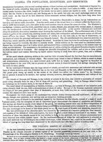
Dall, W. H., 1918, Reminiscences of Alaskan volcanoes: Scientific Monthly, v. 7, n. 1, p. 80-90.
Hard Copy held by AVO at FBKS - CEC file cabinet
Sapper, Karl, 1917, Katalog der geschichtlichen vulkanausbruche: Strassburg, Germany, Karl J. Trubner, 358 p.
Hard Copy held by AVO at FBKS - CEC file cabinet
Cordeiro, F. J. B., 1910, The volcanoes of Alaska: Appalachia, v. 12, p. 130-135.
Hard Copy held by AVO at FBKS - CEC file cabinet
Jaggar, T. A., 1908, Journal of the technology expedition to the Aleutian Islands, 1907: The Technology Review, v. 10, n. 1, p. 1-37.
Hard Copy held by AVO at FBKS - CEC file cabinet
Eakle, A. S., 1908, Recent volcanic eruptions in the Bering Sea: Mining and Scientific Press, v. 96, p. 353.
Hard Copy held by AVO at FBKS - CEC file cabinet
Plummer, F. G., 1898, Reported volcanic eruptions in Alaska, Puget Sound, etc., 1690-1896: in Holden, E. S., (ed.), A Catalogue of Earthquakes on the Pacific Coast 1769-1897, Smithsonian Institution Miscellaneous Collections 1087, City of Washington D.C., Smithsonian Institution, p. 24-27.
Hard Copy held by AVO at FBKS - CEC file cabinet
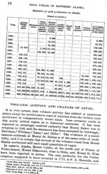
Becker, G. F., 1898, Reconnaissance of the gold fields of southern Alaska with some notes on general geology: U.S. Geological Survey Annual Report 0018, p. 1-86, 6 sheets, scale unknown.
Hard Copy held by AVO at FBKS - CEC file cabinet
Dawson, G.M., 1894, Geological notes on some of the coasts and islands of the Bering Sea and vicinity: Geological Society of America Bulletin, v. 5, p. 117-146.
Petroff, Ivan, 1884, The volcanic region of Alaska: in Population, Industries, and Resources of Alaska, Washington DC, Government Printing Office, p. 93-96.
Hard Copy held by AVO at FBKS - CEC file cabinet
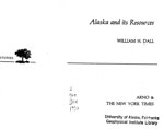
Dall, W. H., 1870, Alaska and its resources: Boston, Lee and Shepard, 627 p.
Hard Copy held by AVO at FBKS - CEC file cabinet
Perrey, Alexis, 1866, Documents sur les tremblements de terre et les phenomenes volcaniques des iles Aleutiennes, de la peninsule d'Aljaska et de la cote no. d'Amerique, Extrait des memoires de l'Academie des sciences, arts et belles-lettres de Dijon, 1865: Dijon, J.E. Rabutut, 131 p.
Hard Copy held by AVO at FBKS - CEC file cabinet
Grewingk, Constantine, 1850, Grewingk's geology of Alaska and the Northwest Coast of America [edited by Marvin W. Falk, translation by Fritz Jaensch published 2003]: Rasmuson Library Historical Translation Series 11, Fairbanks, AK, The University of Alaska Press, 242 p.
Hard Copy held by AVO at FBKS - CEC shelf
Coats, R. R., Past volcanic activity in the Aleutian arc: U.S. Geological Survey Volcano Investigations Report 1, 18 p.
Hard Copy held by AVO at FBKS - CEC file cabinet
Kienle, Juergen (comp.), Volcano observations: Notes about volcanoes and volcanic eruptions collected, made, and stored by Juergen Kienle, on file at University of Alaska Fairbanks, Geophysical Institute, unpublished, unpaged.