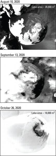
Digital Globe satellite images of the summit of Korovin volcano. The crater lake may be slightly smaller in the October 26 image relative to its extent in the August 10 image. It is possible that this is a result of a decline in runoff associated with the onset of winter. Images acquired with USGS NextView License.
Volcano(es): Korovin
Photographer: Waythomas, Christopher
URL: avo.alaska.edu/image/view/162321
Credit: Image courtesy of AVO/USGS.
AVO does not hold copyright to this image and displays it with the permission of the copyright holder. This image is NOT in the public domain. Please see the use restrictions below.
Use Restriction: Please cite the photographer and the Alaska Volcano Observatory / U.S. Geological Survey when using this image.
Full Resolution.
Korovin unrest 2020/10
From Orr and others, 2024: "The first indication of unrest at Atka volcanic complex in 2020 was a small increase in seismic activity. This activity started in early June and culminated with episodic tremor on June 11-12. The amplitude of the tremor pulses, which each lasted 10-40 minutes, increased slowly and peaked on June 12 at ~13:50 UTC (~04:50 HADT). The tremor then subsided to background levels for the next several months.
"Beginning on October 15, the TROPOMI satellite instrument made occasional SO2 detections at Atka volcanic complex. These SO2 detections were the first at the complex in 2020 and indicated elevated volcanic degassing. An additional two satellite SO2 detections were made during the next two weeks, which also coincided with an increase in the number of earthquakes located in the area. In response to this heightened level of activity, AVO elevated the Aviation Color Code and Volcano Alert Level to YELLOW and ADVISORY on October 28. No additional satellite SO2 detections were made in the following weeks, and seismicity declined in late November, indicating a return to background activity. AVO subsequently lowered the Aviation Color Code and Volcano Alert Level back to GREEN and NORMAL on December 3."