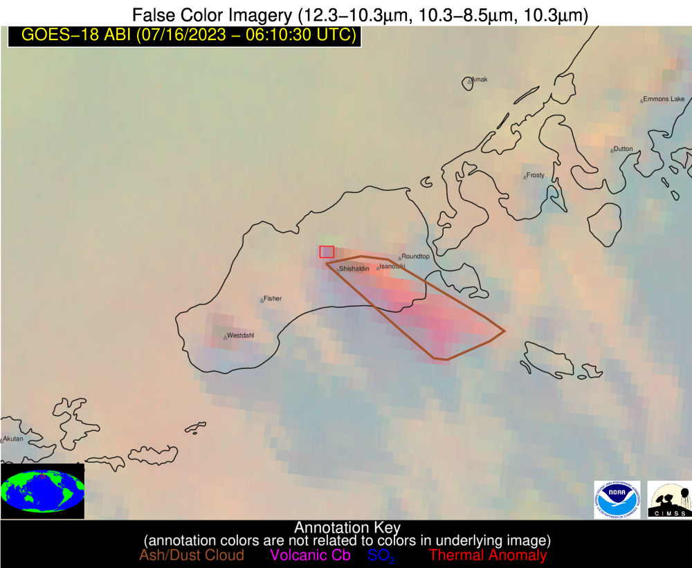
False color GOES-18 satellite imagery showing an ash plume (pink-brown region) extending southwest from Shishaldin Volcano on July 16, 2023, 6:10 UTC (July 15, 10:10 pm AKDT). The current eruption is generating this ash cloud, which is reaching an altitude of 14,000-16,000 ft above sea level. The false color image combines different wavelengths of infrared light to distinguish volcanic activity, such as the thermal anomaly from elevated surface temperatures at the summit of the volcano highlighted in the red box, and an ash cloud highlighted in the brown polygon.
Volcano(es): Shishaldin
Photographer: Dietterich, Hannah
URL: avo.alaska.edu/image/view/194422
Credit: Imagery and volcanic activity detections provided by NOAA/CIMSS Volcanic Cloud Monitoring
Use Restriction:
Full Resolution.
Shishaldin 2023/07
On July 11, 2023, AVO raised the Aviation Color Code to YELLOW and the Alert Level to ADVISORY for Shishaldin Volcano, citing the following information:
Strongly elevated surface temperatures at the summit of Shishaldin Volcano have been observed in satellite data over the past day. Intermittent tremor and low-frequency earthquakes over the past week have gradually become more regular and consistent in the past day. In response, the Alaska Volcano Observatory is raising the Aviation Color Code to YELLOW and the Alert Level to ADVISORY. These observations represent a departure from normal background activity at Shishaldin, but do not necessarily indicate that an eruption will occur.
On the following day, July 12, AVO raised the Aviation Color Code to ORANGE and the Alert Level to WATCH for Shishaldin, citing the following information:
Strongly elevated surface temperatures continue to be observed at the summit of Shishaldin Volcano in satellite data. Incandescence at the summit was observed in web camera images from last night and sulfur dioxide was detected in satellite data over the past day. In addition, seismic tremor amplitudes have increased over the past day. Together, these observations suggest that lava is likely present within the summit crater of Shishaldin.
On Friday, July 14, two explosions at 1:09 and 7:10 am AKDT, producing ash clouds to 25,00-40,000 feet (9-12 km) asl. Plumes drifted SE across the Pacific for at least 250 mi. Volcanic mudflows were generated on volcano’s flanks, the largest on the north side. Gas detections suggest elevated SO2 in the ash plume. Several smaller explosions with ash clouds below 15,000 ft occurred around 10:30 am. The Color Code and Volcano Alert Level remained ORANGE/WATCH.
On the evening of Saturday July 15, the eruption intensified, and AVO raised the Aviation Color Code and Volcano Alert Level to RED/WARNING at 11:57 pm AKDT, stating "The explosive eruption of Shishaldin Volcano is continuing. A continuous ash plume now extends over 80 mi (125 km) to the SSE from the volcano with an altitude of about 16,000 ft (4.9 km) above sea level. Seismicity has remained elevated for over 6 hours and frequent explosion signals are being detected at regional infrasound (pressure sensor) networks. Some explosions are sending ash plumes as high as 20,000 ft (6 km) above sea level."
Overnight, the eruptive activity declined and AVO lowered the Color Code and Volcano Alert level to ORANGE/WARNING. The drifting ash cloud was still visible in satellite imagery about 350 nautical miles ESE from the volcano. The NWS estimated the cloud as under 16,000 ft asl.
Lava continued to erupt from the summit crater on July 16 and 17.
Tuesday July 18 saw a return to explosive activity, with a rapidly growing ash cloud observed starting at 7 am local time and drifting SSE. AVO raised the Aviation Color Code and Volcano Alert Level to RED/WARNING in response for approximately three and a half hours.
On Wednesday, July 19, seismic stations and webcams south of the volcano were brought back online, increasing the monitoring capabilities at Shishaldin.
Another episode of eruptive activity occurred over the following weekend, starting late Saturday, July 22. The Aviation Color Code and Volcano Alert Levels were raised to RED/WARNING at 11:43 PM after an ash plume was observed in satellite data. The plume reached altitudes of 37,000 ft asl and drifted to the northeast. Alert levels were returned to ORANGE/WATCH four and a half hours later.
In the early morning hours of Wednesday, July 26, a sustained period of increased eruptive activity began. A more low-level ash plume reached 15,000 ft asl by 3:51 AM and continued for many hours, along with significant explosions. The Aviation Color Code and Volcano Alert Levels remained at ORANGE/WATCH during this event.
On the Thursday of the week following, August 3, volcanic tremor increased into the evening and surface temperatures were strongly elevated. Explosions were detected overnight in infrasound and seismic data. An ash plume reaching up to 31,000 ft erupted starting in the early morning hours of August 4 and continued into the afternoon, declining about 2 PM local time. The Aviation Color Code and Volcano Alert Levels were raised to RED/WARNING at 10:17 AM local time August 4 and were returned to ORANGE/WATCH at 7:55 PM that night.
On Monday, August 15, Shishaldin erupted an ash plume beginning around 2 AM local time that reached about 36,000 ft and generated volcanic lightning. Ash continued to erupt to lower altitudes (~16,000 feet) into August 16. The Aviation Color Code and Volcano Alert Levels remained at ORANGE/WATCH during this event.
On Friday, August 25, seismic unrest ramped up in the early morning hours and the first pilot reports of ash were received at 11:22 AM. The Aviation Color Code and Volcano Alert Levels were raised to RED/WARNING at 12:17 PM, and the ash plume eventually reached up to 32,000 ft and extended up to 280 miles. Ash emissions continued into the night and the Aviation Color Code and Volcano Alert Levels were returned to ORANGE/WATCH at 12:28 AM on August 26.
On Tuesday, September 5, seismicity once again increased in the early morning hours, and an ash plume to 32,000 ft was erupted starting about 8:30 AM. Aviation Color Code and Volcano Alert Levels were raised to RED/WARNING at 8:42 AM local time. The ash altitude and emissions decreased about 11 AM, but still continued at lower altitudes until about 1:30 PM. The Aviation Color Code and Volcano Alert Levels were returned to ORANGE/WATCH at 12:46 PM local time.
On Thursday, September 14, seismicity began ramping up about 6 pm local time, but decreased again without major eruptive activity. However, seismicity increased again on Friday, September 15, and an explosive eruption began about 5:10 PM local time. The Aviation Color Code and Volcano Alert Levels were raised to RED/WARNING at 5:41 PM. The ash plume reached 42,000 ft and abundant volcanic lightning was observed. The ash plume detached from the volcano about 6:30 PM, but more ash erupted starting at 7:30 PM. Trace ash fall was reported in False Pass during this event. The Aviation Color Code and Volcano Alert Levels wee returned to ORANGE/WATCH at 12:44 AM Saturday, September 16, after seismicity returned to pre-event levels.
On Friday, September 22, seismicity began increasing throughout the day without major explosive activity. Lava erupted within the crater starting on September 24, accompanied by low-level ash emissions and flows down the mountain’s flanks. In the early morning hours of Monday, September 25, an ash plume erupted starting at about 5:45 AM local time, reaching 45,000 ft. The Aviation Color Code and Volcano Alert Levels were raised to RED/WARNING at 6:02 AM. The ash plume detached about 7 AM. Trace ash fall was reported in False Pass, King Cove, Cold Bay, and Sand Point. The Aviation Color Code and Volcano Alert Levels were returned to ORANGE/WATCH at 12:34 PM Monday.
After the major event on September 25, seismic activity decreased, but several collapse events occurred in the crater area and steaming pyroclastic flow and lahar deposits were seen on the volcano’s flanks.
On Monday, October 2, seismicity began increasing in the evening starting around 9 PM local time. Lava fountaining and hot avalanches occurred during the night. A significant explosive eruption of Shishaldin started at 5:47 AM AKDT the following morning, October 3. The explosive eruption produced an initial ash cloud as high as 40,000 ft asl, with subsequent ash emissions to between 20,000 and 25,000 ft asl. The eruption was observed in satellite images, webcams, lightning, and seismic and infrasound data. The Aviation Color Code and Volcano Alert Levels were raised to RED/WARNING at 6:12 AM. Ash emissions continued for several hours, dropping down to about 20,000 to 25,000 ft asl. The Aviation Color Code and Volcano Alert Levels were returned to ORANGE/WATCH at 10:36 am October 3 after explosive activity ended, although steaming and small collapse events continued.
After the event on October 3, seismic activity remained elevated for two weeks. Pyroclastic flow and lahar deposits were observed, along with explosion craters at their toe, as was evidence for more collapses of the crater rim. Shishaldin emitted increased levels of sulfur dioxide (SO2) during the weeks of October 9 and October 16. Seismicity and sulfur dioxide emissions began to decline the week of October 23.
On Tuesday, October 31, AVO changed the Aviation Color Code and Volcano Alert Levels to YELLOW/ADVISORY, citing the decrease in seismicity and sulfur dioxide emissions over the past week.
Two days later, on Thursday, November 2, volcanic tremor increased again. The Aviation Color Code and Volcano Alert Levels were raised back to ORANGE/WATCH at 8:31 PM AKDT that night, with AVO stating that an eruption was likely underway. Satellite images showed ash emissions started at about 8:00 PM local time. The emissions lasted until Friday morning, but as the ash plume didn’t exceed 20,000 ft above sea level, the Aviation Color Code and Volcano Alert Levels remained at ORANGE/WATCH during this event.
After the explosive event on November 3, much smaller explosions and collapse events around the summit crater rim occurred frequently for about a week, along with above-background levels of seismicity, elevated surface temperatures, and steam and gas emissions. During the weeks following, the frequency of small explosions detected in infrasound data dropped off, and gas emissions and elevated surface temperatures were less frequently detected. Seismicity remained somewhat elevated, and steam plumes and collapse events were sometimes observed. There was a small cluster of earthquakes starting on December 25 about 4-6 miles southwest of Shishaldin's summit.
On January 2, AVO lowered the alert levels to YELLOW/ADVISORY, stating that activity had declined over the two months prior, and that there had not been any evidence of eruption-driven changes to the volcano outside of the crater or evidence of lava within the crater. However, unrest continued with the small events taking place deep in the vent.
Minor steam emissions and seismicity (including occasional tremor) continued in January and February, but explosion signals dropped off. Steam emissions were observed on and off in webcam views.
On February 11, a minor ash plume was observed in a webcam view, prompting AVO to raise the alert levels to ORANGE/WATCH at 12:46 PM AKST. Analysis of seismic, infrasound, and thermal data indicated no evidence of explosive activity, which led AVO to conclude that this event was most likely caused by a small rockfall or debris flow. Therefore, the alert levels were returned to YELLOW/ADVISORY on February 17. Satellite data on February 17 and 19 showed that additional collapse events had occurred on the upper southeast and northeast flanks, but otherwise activity remained low.
In the latter part of February, Shishaldin was fairly quiet, with barely elevated seismicity and intermittent steaming.
On March 7, an SO2 plume was noted in satellite data. Through the end of April, roughly 1-2 SO2 observations per week were accompanied by some periods of seismic tremor, occasional gas-bubble burst signals noted in infrasound, occasional weakly elevated surface temperatures, and a robust steam/gas plume.
On May 10 through May 16, a few new areas of ash were spotted in webcam images of the snow-covered summit. These were likely caused by minor collapses of the inner crater wall that were observed in radar satellite data. Weak infrasound, occasional tremor, and steam plumes were also observed.
Between May 16 and June 7, volcanic earthquakes and occasional tremor were observed, along with steaming when the weather was clear. SO2 gas was observed on six days during this period.
Between June 7 and July 12, sulfur dioxide gas emissions were observed in satellite data several times each week, along with a fairly persistent steam plume, earthquakes, occasional tremor, and weak infrasound explosion signals when observation conditions were good.
Between July 12 and July 26, sulfur dioxide gas observations were less frequent, though other activity remained approximately the same.
Over the week of August 2, an AVO field crew conducted fieldwork at Shishaldin, including helicopter overflights on July 28 and 30 and August 1. Thermal imaging revealed a warm central vent deep within the summit crater, and gas instruments detected sulfur dioxide within the persistent steam and gas plume.
Over the month of August, the typical steam plume was observed during clear weather, along with small volcanic earthquakes and weak seismic tremor and infrasound signals.
On August 30, 2024, AVO returned the Aviation Color Code and Volcano Alert Level to GREEN and NORMAL. The accompanying statement specified that while seismicity was still slightly elevated and gas emissions and small infrasound signals continued at Shishaldin, these signals had declined over time since the last explosive event in November and were expected to persist for a good while longer in the post-eruptive period. In AVO’s opinion, the volcano no longer posed any immediate threat of eruptive activity, and any resumption of activity would be preceded by detectable signals.