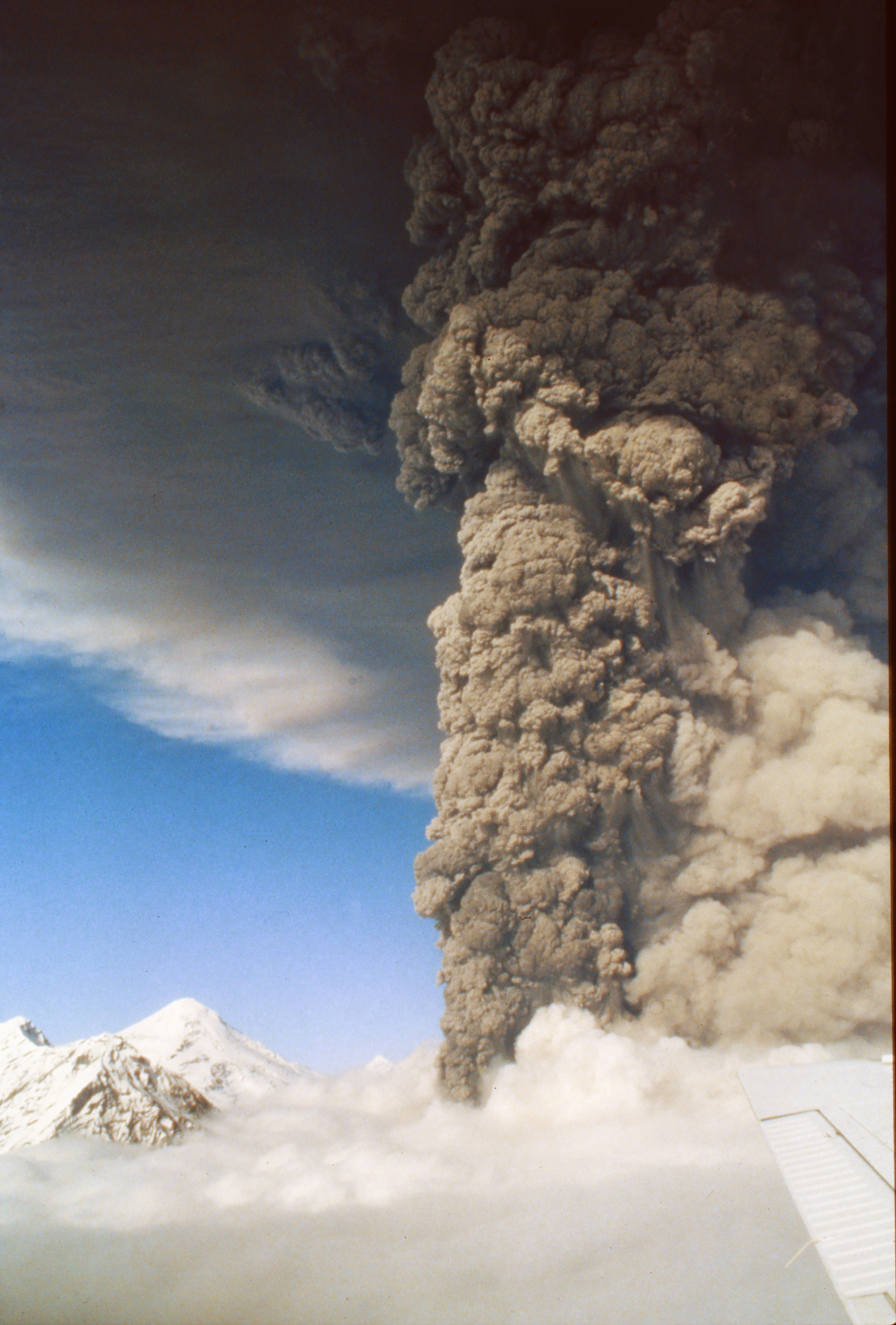
August 18 marks the 23rd anniversary of the secon of three eruptions in 1992 of Crater Peak satellite vent on Mount Spurr volcano. After 10 months of gradually increasing unrest, seismicity beneath Mount Spurr changed dramatically on June 24, culminating in a powerful 4-hour eruption, the first activity from the volcano since a similar eruption in July 1953. Following the June eruption, seismic activity beneath Mount Spurr dropped strikingly to background levels and remained low through the first half of August, seemingly a copy of the 1953 activity; the volcano appeared to be headed back into a slumber. However, with virtually no seismic precursor - other than a 12-minute stretch of weak tremor - the Crater Peak vent burst forth with another powerful eruption late on the afternoon of August 18, 1992. The day was cloudy in Anchorage, and AVO staff, following up on pilot reports of activity, had just become airborne when word came that a full-throttle eruption was in progress. Dramatic images and video were captured of the eruption, which lasted 3 hours and 40 minutes and propelled an ash cloud to an altitude of 13.7 km above sea level (44,950 ft). Westerly winds carried the gritty mass eastward over south-central Alaska. Anchorage, 130 km (80 mi) to the east, was blanketed with 3 mm of sand-sized ash, closing the international airport for 20 hours and widely disrupting commerce and transportation. Traces of ash were reported up to 1,200 km (745 mi) downwind of the vent. AVO scientists spent the next few weeks collecting ash samples for what would become one of the best ash-deposit datasets to date.
Volcano(es): Spurr
Photographer: McGimsey, R. G.
URL: avo.alaska.edu/image/view/66321
Crater Peak 1992/8
For 220 pages of information on the three 1992 eruptions of Crater Peak, please see the USGS Bulletin 2139, available online at: http://www.avo.alaska.edu/pdfs/B2139.pdf ; this file is 9 MB.
From Eichelberger and others (1995): "Following the June [June 27, 1992] eruption, seismicity remained low through the first half of August. Only one shallow and two deep earthquakes were recorded between August 12 and 17. Because the closest operational seismic station at that time was 5 km from the vent, several attempts were made to reestablish a seismic station on the crater rim. These were unsuccessful because of poor weather conditions. At 3:37 p.m. ADT on August 18, a 16-minute episode of weak tremor and several LP [long-period] events began, but these rather obscure events were not identified until post-eruption analysis of the data. At 3:48 p.m. ADT, a pilot reported an ash-rich plume. With confirmation of this plume at 4:25 p.m., AVO began a calldown announcing level of concern color code Yellow. The main eruption began at 4:42 p.m. ADT, when strong tremor was recorded by all Mount Spurr seismic stations. AVO began a calldown announcing color code Orange at 4:47 p.m. ADT, but repeated the calldown process 11 minutes later to raise the color code to Red. By 4:58 p.m. ADT, a subplinian column had risen through low clouds to a height of 11,000 m, and it ultimately reached nearly 14,000 m. From an aircraft only 2.5 km away, AVO staff observed and videotaped a dark roiling cloud that was periodically surrounded by lenticular shock waves. Large bombs were thrown 800 m above the vent. Small-volume pyroclastic flows of breadcrusted blocks descended the east and southeast flanks of Crater Peak; these flows formed coarse, clast-supported lobate deposits with steep-fronted margins. Other flows mixed with snow and ice high on the cone and became lahars. A late fusillade of mostly lithic ballistic projectiles, some as large as 1 m, were hurled as far as 10 km southeastward (Waitt and others, this volume [USGS Bulletin 2139]). More than 170 lightning strikes were detected by the AVO lightning detection system (LDS) during the second half of the eruption (Paskievitch and others, this volume [USGS Bulletin 2139]). The eruption ended at 8:10 p.m. ADT.
"Upper level winds moved the eruption plume east-southeast directly over Anchorage, where it deposited as much as 3 mm of sand-sized ash (Neal and others, this volume [USGS Bulletin 2139]). A satellite image 44 minutes after the onset of the eruption shows the plume extending 80 km east from the volcano over an area of 20,000 square km. Three hours after onset of eruption, the leading edge of the plume was 300 km southeast of Mount Spurr, and its area had grown to 21,000 square km.
"Ashfall forced the closing of Anchorage International Airport for 20 hours (N.W. Gibson, Anchorage International Airport, written commun., 1993). Air quality alerts were issued in Anchorage during the fallout period and also on the following day, as vehicle traffic stirred up ash again (R.B. Stewart, Office of Emergency Management, Municipality of Anchorage, written commun., 1993). Reworked windblown ash continued to reduce air quality until the first snow of autumn, and then it reappeared during the summer of 1993."
Eichelberger and others (1995) state that this eruption produced 52 million cubic m of tephra (14 million cubic m Dense Rock Equivalent).
Please cite the photographer and the Alaska Volcano Observatory / U.S. Geological Survey when using this image.
Full Resolution.