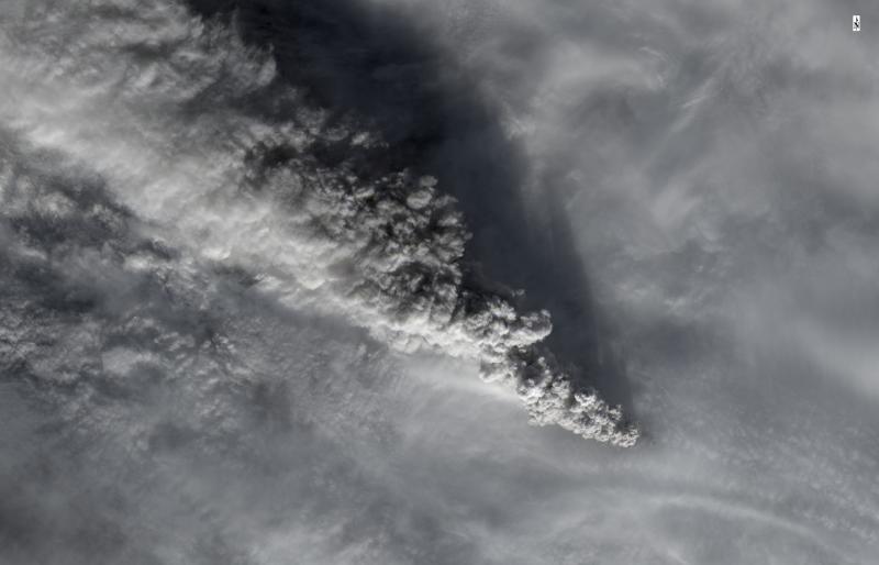
Satellite image from the USGS/NASA Landsat-8 satellite showing the eruption cloud at Pavlof Volcano on November 15 at 12:46 pm AKST (21:46 UTC). This is just a portion of the eruption cloud, which extended for more than 250 miles to the northwest at the time this image was collected. In this image, the distance from the erupting vent to the upper left corner of the image is 45 miles (70 km). The shadow of the eruption cloud on the underlying meteorological clouds can be seen in this image. Pilots reported the height of the cloud at 35,000 ft (10.7 km) above sea level.
Volcano(es): Pavlof
Photographer: Schneider, D. J.
URL: avo.alaska.edu/image/view/68531
Credit: Image courtesy of AVO/USGS.
Use Restriction: Please cite the photographer and the Alaska Volcano Observatory / U.S. Geological Survey when using this image.
Full Resolution.
Pavlof 2014/11
From Cameron and others, 2017: "Pavlof remained quiet and at background levels of seismicity until November 12, when seismic tremor increased sharply and increased surface temperatures were detected in satellite data, suggesting that lava had reached the surface. This was corroborated by reports of minor ash emissions and low-level lava fountaining from observers in Cold Bay. Observers also reported flows of rock debris and ash descending the northern flank of the volcano, and incandescence was observed in Web camera images. As a result of these observations, AVO upgraded the Aviation Color Code and Volcano Alert Level to ORANGE/WATCH on November 12.
"After November 12, the level of seismic activity continued to increase gradually and the thermal signal at the summit became persistently visible in satellite data. On November 13, satellite data showed a 200-km-long (124-mi-long) ash plume extending northwest of the volcano.Pilot reports estimated the ash cloud top at about 2,400-2,700m (about 7,900-8,900 ft) ASL. For the next 24 hours, all Pavlof seismic stations recorded nearly continuous seismic tremor, and satellite data showed strongly elevated surface temperatures, consistent with sustained lava fountaining. A narrow ash plume extending as high as 200 km (124 mi) from the volcano continued to be visible in satellite data, and information from passing pilots indicated that the ash plume eventually reached an altitude of about 4,800 m (15,700ft) ASL. Minor SO2 emissions were detected on November 14 in satellite data.
"On November 15, the intensity of seismic tremor increased significantly over a 6-hour period and satellite data indicated that the ash cloud, visible for the previous several days, had expanded and reached an altitude of about 7,600m (25,000 ft) ASL, and extended at least 200 km (124 mi) northwest of the volcano. In response to this increase in eruptive activity, AVO upgraded the Aviation Color Code and Volcano Alert Level to RED/WARNING. This plume eventually reached an altitude of at least 11,000 m (36,000ft)
ASL and extended about 385 km (240 mi) northwest of the volcano. Although the volcano was obscured by clouds, observers in Cold Bay reported rumbling and thunder-like sounds coming from the direction of Pavlof Volcano. Infrasonic tremor levels detected by the infrasound array in Dillingham increased steadily through the day on November 15 and were as high as, or higher than, infrasound levels recorded at any time during Pavlof’s May-June 2014 or 2013 eruptions (David Fee, UAFGI/AVO, written commun., 2014). The SO2 plume generated by this phase of the eruption extended west over the Bering Strait and into eastern Russia.
"Seismicity at the volcano decreased significantly on November 16 and remained at low levels, and ash plumes were not observed in satellite data thereafter. In response to thedecrease in seismicity and ash emission, AVO downgraded the Aviation Color Code and Volcano Alert Level to ORANGE/WATCH on November 16.
"Satellite observations indicated that eruptive activity ceased by about November 17. The intensity of thermal signals decreased gradually and the levels of tremor fluctuated slightly, but the overall amplitude decreased steadily. Thermal signals were occasionally observed in satellite datathrough November 26, but were the result of the still hot lava and debris on the northern flank of the volcano. As a result of the diminished levels of unrest, AVO downgraded the Aviation Color Code and Volcano Alert Level to YELLOW/ADVISORY on November 26, UTC (November 25, AKST).
"No further eruptive activity occurred at Pavlof Volcano in 2014, although unstable accumulations of cooling lava spatter occasionally collapsed, generating small ash emissions. The volcano gradually returned to normal background status, and on January 15, 2015, AVO downgraded the Aviation Color Code and Volcano Alert Level to GREEN/NORMAL."