Volcanoes of Alaska
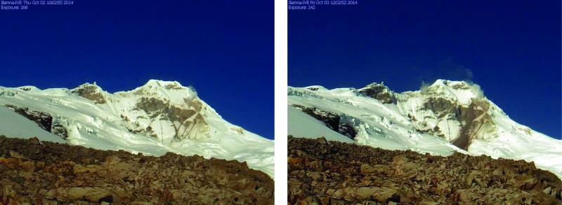
Below is an alphabetical list of volcanoes. These links will take you to information specific to that volcano. Each volcano has descriptions, images, maps, bibliography, and eruption history.
indicates a volcano is recently active.
indicates a volcano was active in the Holocene.
indicates a volcano has been active within the last 2 million years, but not within the last 10,000 years.
About Alaska Volcanoes
Alaska contains about 140 volcanoes and volcanic fields active within the last 2.6 million years (the Quaternary).
About 90 of these volcanoes have been active within the last 11,000 years (the Holocene), and more than 50 have been very recently active, within the last 300 years or so.
The volcanoes in Alaska make up more than three-quarters of U.S. volcanoes that have erupted in the past 200 years.
Most of Alaska’s volcanoes are located along the 2,500 km (1,500 mi) Aleutian Arc, which extends westward from the mainland of Alaska towards Kamchatka, and forms the northern portion of the Pacific “ring of fire.” Other volcanoes in Alaska that have been active in the last few thousand years exist in southeastern Alaska (Edgecumbe), and the Wrangell mountains. Smaller volcanoes, some active within the past 11,000 years, are found in interior Alaska and in western Alaska, as far north as the Seward Peninsula.
Check out our FAQ for answers to some common questions.
Or look at a volcano's page for more information about that volcano.
Hazards from Alaska Volcanoes
General hazards from Alaska volcanoes
The most significant - and common - hazards from Alaska volcanoes are those created by ash clouds and ashfall. Alaska’s volcanoes are distributed under Pacific great circle aircraft routes (traversed by more than 50,000 people per day), and can erupt ash clouds into commercial and recreational airspace. Ash and aircraft do not mix, as volcanic ash is abrasive, melts at jet engine temperatures, and can cause engine failure. Alaska communities downwind of an erupting volcano often encounter ash fallout, which is both a problem for infrastructure (mechanical systems, power generation and transmission, water systems, transportation, communication systems) and a respiratory hazard.
Other hazards from Alaska volcanoes have occurred, but are less likely. Please scroll down this page or use the left-hand navigation bar to learn more details about hazards from Alaska volcanoes.
Far Field Hazards
Hazards from Alaska volcanoes that may affect human activities both near and far from the volcano
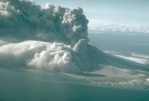
Volcanic Ash Clouds
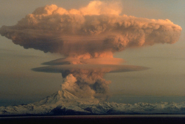
The principal hazard associated with future explosive eruptions of Alaska volcanoes is the generation of volcanic ash clouds which are explosively blasted high into the atmosphere and then drift away from the volcano with the wind. Ash-rich clouds produced during large eruptions can reach heights of 30,000 to 65,000 ft (10 to 20 km) or more above the volcano, although most Alaska eruptions are smaller (a few thousand ft to 20,000 ft). Prevailing North Pacific winds usually carry ash clouds eastward from the volcano, but dispersal in other directions is possible, depending on wind patterns at the time of the eruption.

Alaska airspace is extremely busy with long-range, wide-body aircraft as well as bush planes and smaller aircraft. The Ted Stevens Anchorage International Airport is the fifth busiest cargo airport in the world (Airports Council International, 2014), and the busiest cargo airport in the United States. More than 50,000 people fly over or very near Alaska volcanoes as they travel the North Pacific (NOPAC) and Russian Far East (RFE) air routes. The high volume of air traffic is due to Alaska’s unique geographic location. All direct air routes between the United States (even Los Angeles and New York) and Asian cities such as Tokyo and Hong Kong pass along the NOPAC routes. Most of the aircraft carrying freight between Europe and Asia come through Alaska for refueling. A considerable percent of all air freight on earth passes near Alaska’s many volcanoes.

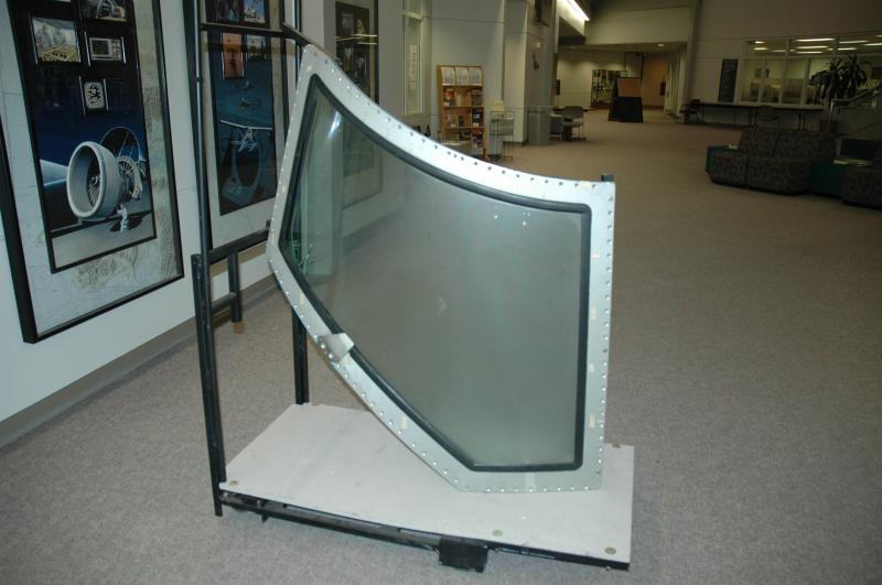
Encounters between aircraft and volcanic ash are serious because the ash can cause severe damage to the engines as well as other parts of the airplane. Volcanic ash is abrasive, and melts at the high operating temperatures of modern jet engines. When ingested into a jet engine, volcanic ash erodes turbine blades, and the melted ash can adhere to critical parts, causing engine failure. Any forward-facing surface of an airplane engulfed in a volcanic ash cloud is likely to be eroded, including the cockpit, forward cabin windows and landing-light covers. Cockpit windows may be abraded enough to cause a serious loss of forward visibility. Ash entering sensitive electronics can interfere with navigation and other onboard systems. As a result of electrical disturbances within the ash cloud, a flight crew may also lose the ability to transmit a distress call. Sulfur and other gases released in large eruptions also affect aircraft and their occupants. Acidic aerosols formed by the hydration of these volcanic gases produce a corrosive mist that may cause respiratory problems for passengers and flight crews and accelerate deterioration of vulnerable aircraft components [1]
Between 1953 and 2010, worldwide, there were at least 79 aircraft-volcanic ash encounters that resulted in damage to the aircraft [2] . Nine of these encounters resulted in engine shutdown during flight.
In Alaska, the most serious ash-aviation incident took place on December 15, 1989, when a Boeing 747-400 aircraft temporarily lost power of all four engines after encountering an ash cloud from Mount Redoubt as the airplane descended for a landing in Anchorage. After steeply gliding to a descent of more than 14,000 ft (4.3 km), the pilot was able to restart the engines and land safely in Anchorage. While there were no injuries to passengers, the damage to engines, avionics, and aircraft structure from this encounter was estimated at $80 million [3] . Recent eruptions of Alaska volcanoes have resulted in flight delays and cancellations for regional and international flights.
For more information on volcanic ash impacts and mitigation, visit http://volcanoes.usgs.gov/volcanic_ash/
Volcanic Ash Fallout
For detailed information on what it is like during ashfall, please see this page: http://volcanoes.usgs.gov/volcanic_ash/what_like_during_fall.html
Alaska communities downwind of an erupting volcano may encounter ash fallout. Fine ash may cause respiratory problems in some humans and animals. Heavy ash fallout may interfere with power generation and electrical equipment, damage air filters and gasoline engines, interrupt radio and cell phone transmissions, and greatly reduce visibility. The weight of very thick ashfalls may collapse roofs, especially when mixed with rain or snow. Resuspension of ash by wind could extend the unpleasant effects of ash fallout.
| Term | Accumulation (inches, decimal inches, & mm) | Key Impact Thresholds (cumulative) |
|---|---|---|
| Trace or dusting | < 1/32 in< 0.031 in< 0.8 mm | Eye and respiratory irritant, very low level impacts for most people. |
| Minor | 1/32 - 1/4 in0.031 - 0.25 in0.8 - 6.4 mm | Possible crop, animal equipment, and infrastructure problems; widespread clean-up likely. |
| Moderate | 1/4 - 1 in0.25 - 1.0 in6.4 - 25.4 mm | Ash removal efforts significant. |
| Heavy | 1 - 4 in1.0 - 4.0 in25.4 - 100 mm | Weaker roofs can fail at ~ 4-5 inches of compacted, wet ash accumulation (~40 lb/ft2). |
| Very Heavy | 4 in - 12 in4.0 - 12.0 in100 - 300 mm | Danger of roof collapse increases, damage to trees, essential services interrupted. |
| Severe | > 12 in> 12 in> 300 mm | Roads impassable, severe infrastructure damage, heavy plant and animal loss. |
Table of ashfall severities based on accumulated thickness. As shown on the ash website
During the most recent eruptions in Alaska, communities have received no more than trace amounts of ashfall (1/32 in or 0.8 mm), although even small amounts of volcanic ash has resulted in transportation delays, school and business closures, and presented challenges to power and water systems. Recent eruptions of Cook Inlet volcanoes (Augustine, Spurr, Redoubt) have produced trace amounts of ash to south-central Alaska, especially the Kenai Peninsula, resulting in airport, school, and business closures, as well as ash cleanup costs and stockpiling of emergency supplies. The 2008 eruption of Kasatochi deposited a small amount of ash on Adak, and eruptions of Pavlof often result in very minor ashfall on nearby communities.
Looking a little further back, however, the largest eruption of the 20th century was the 1912 Novarupta-Katmai eruption, on the Alaska Peninsula. This eruption produced ashfall as far away as Dawson City (Yukon, Canada), Ketchikan (southeast Alaska), and the Puget Sound in Washington State. During the 3 days of the eruption darkness and suffocating conditions caused by falling ash and sulfur dioxide gas immobilized the population of Kodiak, Alaska. Sore eyes and respiratory distress were rampant, and water became undrinkable. Radio communications were totally disrupted, and with visibility near zero, ships couldn't dock. Roofs in Kodiak collapsed under the weight of more than a foot of ash, buildings were wrecked by ash avalanches that rushed down from nearby hillslopes, and other structures burned after being struck by lightning from the ash cloud. Similar conditions prevailed elsewhere in southern Alaska, and several villages were abandoned forever. Within 50 miles (80 km) of the erupting vent, animal and plant life was decimated by ash and acid rain. Bears and other large animals were blinded by ash and starved when large numbers of the plants and small animals they lived on were wiped out. Millions of dead birds that had been blinded and coated by volcanic ash littered the ground. Aquatic organisms, such as mussels, insect larvae, and kelp, as well as the fish that fed upon them, perished in ash-choked shallow water. Alaska's salmon-fishing industry was devastated, especially from 1915 to 1919, because of the starvation and failure of many adult fish to spawn in ash-choked streams [4] [5] [6]
The geological record also shows that many Alaska communities are underlain by significant amounts of volcanic ash. For example, most of south-central Alaska was covered in ash during large eruptions of Hayes volcano in the Tordrillo Mountains, 4,400–3,600 years ago [7] . Prehistoric eruptions of Makushin left deposits of ash that are tens of inches thick at Unalaska [8] . Eruptions from Mount Edgecumbe, 12,000-14,000 years ago, produced ash deposits about 3 ft (1 m) thick in Sitka [9] . AVO is working to understand the eruptive history of Alaska Volcanoes by studying the timing, distribution and amount of ash deposits since the last major ice sheets in Alaska retreated some 10,000-15,000 years ago.
For further information on volcanic ash fallout hazards and mitigation, visit volcanoes.usgs.gov/volcanic_ash/
Volcanic Tsunami
Volcanic tsunami occur very rarely, but might accompany an extremely large eruption. Debris avalanches or pyroclastic flows that travel into the sea or lakes may generate unusually large waves, known as volcanic tsunami, by rapidly displacing water. Tsunamis are also occasionally produced by volcanic earthquakes, explosions, or other eruptive processes. One of our best-known volcanogenic tsunamis occurred during the 1883 eruption of Augustine volcano. During this eruption, a large debris-avalanche occurred at Burr Point on Augustine Island, displacing ocean water and creating an “earthquake wave” of 25 to 30 ft high in Port Graham on the Kenai Peninsula [10] [11] . The logbook at English Bay recorded “tidal” waves 20 ft higher than usual.
Near Field Hazards
Hazards from Alaska volcanoes that affect areas close to the volcano
The following hazards occur only within a few miles of the volcano. Because most Alaska volcanoes are remote from human communities, these hazards often do not affect human activities.
Lahars and floods
Lahars (fast-moving slurries of water, mud, rocks, and sand) may form when hot volcanic debris melts the snow and ice that mantles most of Alaska’s volcanoes. These flows would follow streams and drainages, and may affect infrastructure or communities along these paths.
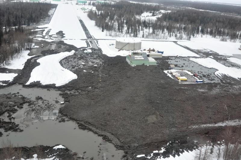
Lahars from Redoubt’s 1989-90 and 2009 eruptions damaged oil production storage facilities within the Drift River valley on the west side of Cook Inlet, resulting in decreased oil production during and after the eruptions.
Volcanic Gases
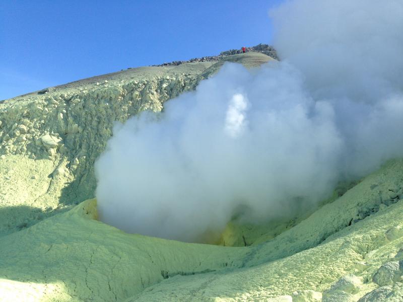
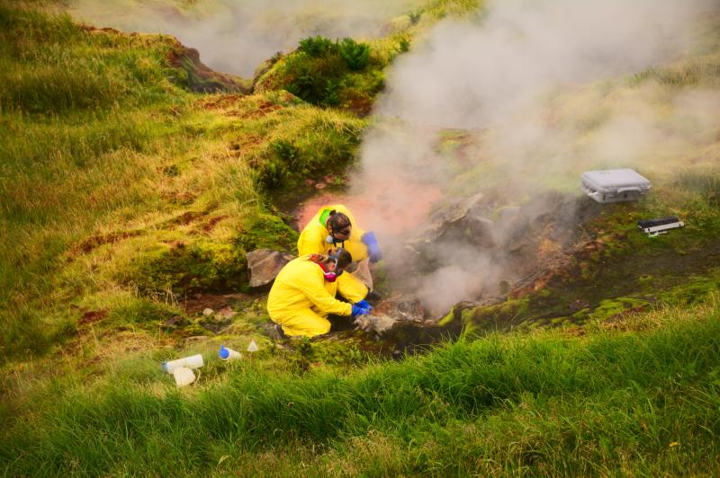
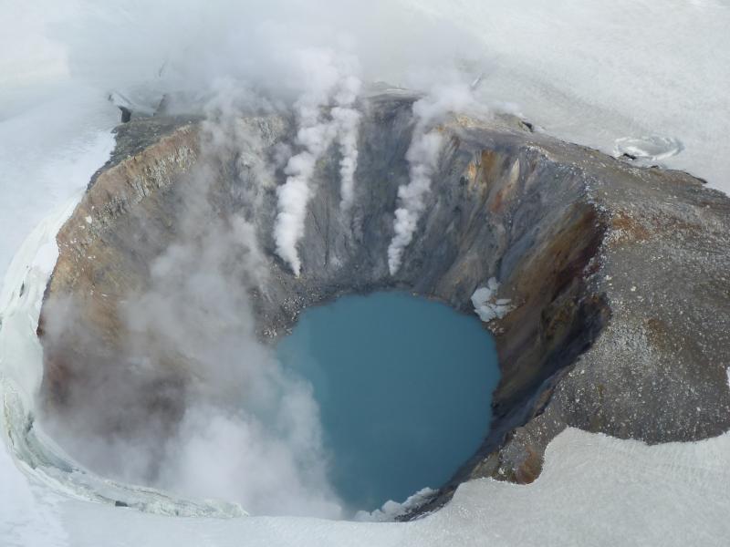
Volcanic vents often emit steam and gases, including hydrogen sulfide, carbon dioxide and sulfur dioxide, in concentrations that are potentially harmful to humans. Reports of sulfur dioxide and hydrogen sulfide smell (rotten eggs) are common from mariners, pilots and people on the ground from Alaska volcanoes but these concentrations do not pose a significant health hazard. Lava flows can also emit large amounts of steam and gas. Dangerous invisible, odorless volcanic gases can collect in low-lying areas near fumaroles, making it inadvisable to descend into craters, caves, or fissures occupied by fumaroles.
Pyroclastic Flows and Surges
Pyroclastic flows (incandescent flows of ash, gas, and volcanic rock) and surges (hurricane-force blasts of turbulent hot gas and ash clouds) can race down slopes at speeds as great as 330 ft per second (100 m per second), travel 6 to 18 miles (10 to 30 km) from the vent, and overtop hills and other topographic obstacles. Large pyroclastic flows that enter water may cause a tsunami.
Ballistics
Explosive eruptions can blast pebble- to boulder-sized or larger fragments of rock, ice, or pumice into the air, where they travel on arcuate, ballistic trajectories away from the vent. These projectiles, called ballistics, fall at high speed, and can injure or kill people, and crush or damage equipment and buildings. Most ballistics will fall within a few miles of the vent.
Lava Flows and Lava Domes
Flows of molten rock (lava) may erupt from Alaska volcanoes. These flows will probably move slowly and pose little hazard to humans. Lava flows may develop steep, blocky fronts that collapse on occasion. Avalanching of blocks from a flow front could be hazardous to someone nearby. If lava reaches the ocean, explosions and unstable ground are possible.
Rockfalls and Landslides
Alaska volcanoes often have steep cliffs that are prone to rockfalls and small landslides. Hydrothermal alteration may create additional rock instabilities, especially at volcanoes like Iliamna. The frequency and size of these events is likely to increase during times of eruption or earthquakes.
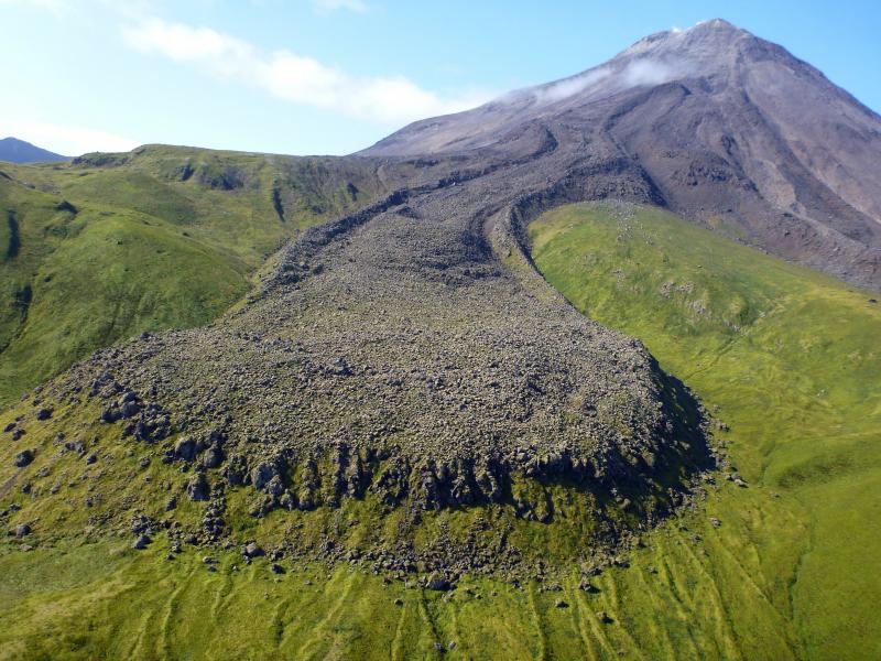
Debris Avalanches
A debris avalanche is a rapidly moving mass of rock debris produced by a large-scale landslide from the summit area of a volcano. The steep slopes of stratovolcanoes, with unconsolidated mixed material, are especially prone to debris avalanches. Debris avalanches may travel several kilometers before coming to rest, or they may transform into more water-rich lahars, and travel tens of kilometers downstream. These events are often, but not always, accompanied by volcanic eruptions.
Directed Blasts
A directed blast is a laterally directed explosion of the volcano caused by rapid release of internal pressure. Most directed blasts are caused by a slope failure of newly erupted lava domes or sector collapse of the summit edifice into a debris avalanche, resulting in rapid depressurization of a shallow magma body. Directed blasts can destroy structures throughout a large radial zone extending 6 to 15 mi (10-25 km). In the United States, our most well-known example of a directed blast occurred during the May 18th, 1980 explosion of Mount St. Helens, in Washington. More information on that event is available here: http://pubs.usgs.gov/gip/msh/lateral.html