Bobrof
Spurr
Great Sitkin
Akutan
Aniakchak
Atka volcanic complex
Augustine
Cleveland
Dutton
Edgecumbe
Fisher
Gareloi
Great Sitkin
Griggs
Iliamna
Isanotski
Kanaga
Katmai
Little Sitkin
Mageik
Makushin
Martin
Novarupta
Pavlof
Redoubt
Semisopochnoi
Shishaldin
Snowy
Spurr
Takawangha
Tanaga
Trident
Ugashik-Peulik
Ukinrek Maars
Veniaminof
Westdahl
Wrangell
Legend
✕
| Red (Warning) | |
| Orange (Watch) | |
| Yellow (Advisory) | |
| Green (Normal) | |
| Uninstrumented | |
| Community | |
| Webcam | |
| Instrument | |
| Earthquake Magnitude | |
|
0
| |
| Earthquake Age | |
| Last 2 Hours | |
| Last 2 Days | |
| Last 1 Week | |
Facts
- Official Name: Bobrof Volcano
- Seismically Monitored: No
- Color Code: UNASSIGNED
- Alert Level: UNASSIGNED
- Elevation: 738m (2421ft)
- Latitude: 51.9072
- Longitude: -177.4409
- Smithsonian VNum: 311100
- Pronunciation:
-
Nearby Towns:
- Adak 35 mi (56 km) SE
- Atka 139 mi (224 km) NE
- Shemya Station 361 mi (581 km) NW
- Nikolski 368 mi (592 km) NE
- Attu Station 399 mi (642 km) NW
Distance from Anchorage: 1216 mi (1958 km)

Description
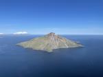
From Wood and Kienle (1990) [1] : "Andesitic pyroclastic flows sampled at a seismic station (Adak network) are indicative of explosive eruptions; lavas at the same site indicate that more quiescent extrusive activity also occurred. Texturally, the rocks resemble those of Moffet volcano 50 km to the east. The geology of this small island and the timing of its volcanism are unknown."Name Origin
Bobrof Volcano, comprising Bobrof Island, bears the name of the island. The name "Bobrof Island" was reported in 1790 by Commodore Joseph Billings. Captain Tebenkov (1852) published the name "O[strov] Bobrovoy Vilga" or "Sea Otter Vilga Island." (Orth, 1971). Bergsland (1994) reports the Unangam Tunuu name of Bobrof Island as "Walĝa", meaning "the one on this side (tribal boundary)."
References Cited
[1] Volcanoes of North America: United States and Canada, 1990
Wood, C. A., and Kienle, Juergen, (eds.), 1990, Volcanoes of North America: United States and Canada: New York, Cambridge University Press, 354 p.Reported Activity
0 Event Date(s)
Past Activity Legend:
| Eruption | |
| Questionable eruption | |
| Non-eruptive activity |


Showing 1 - 15 of 15
Map Images
By:
U.S. Geological Survey
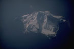
Topographic shaded relief map of Bobrof and Kanaga volcanoes.
Topographic shaded relief map of Bobrof and Kanaga volcanoes.
By:
AllTopo v7
Topographic map of Bobrof Island, compiled in 1954. Army Map Series, Sheet 2524 I NE, Series Q801, Adak C-5 NE, Edition 1-AMS. Scale 1:25,000, Contour Interval 50 feet.
Topographic map of Bobrof Island, compiled in 1954. Army Map Series, Sheet 2524 I NE, Series Q801, Adak C-5 NE, Edition 1-AMS. Scale 1:25,000, Contour Interval 50 feet.
Map References
Digital data for the reconnaissance geologic map of the western Aleutian islands, Alaska, 2006
Wilson, F.H., Mohadjer, Solmaz, Labay, K.A., Shew, Nora, and Grey, D.M., 2006, Digital data for the reconnaissance geologic map of the western Aleutian islands, Alaska: U.S. Geological Survey Open-File Report 2006-1302, 1 p., available online at http://pubs.usgs.gov/of/2006/1302/
Volcanoes of Alaska, 1998
Nye, C. J., Queen, Katherine, and McCarthy, A. M., 1998, Volcanoes of Alaska: Alaska Division of Geological & Geophysical Surveys Information Circular IC 0038, unpaged, 1 sheet, scale 1:4,000,000, available at http://www.dggs.dnr.state.ak.us/pubs/pubs?reqtype=citation&ID=7043 .

Volcanoes of Alaska, 1995
Alaska Division of Geological & Geophysical Surveys, 1995, Volcanoes of Alaska: Alaska Division of Geological & Geophysical Surveys Information Circular IC 0038, unpaged, 1 sheet, scale 1:4,000,000.
Geothermal resources of the Aleutian Arc, 1993
Motyka, R. J., Liss, S. A., Nye, C. J., and Moorman, M. A., 1993, Geothermal resources of the Aleutian Arc: Alaska Division of Geological & Geophysical Surveys Professional Report PR 0114, 17 p., 4 sheets, scale 1:1,000,000.

Map showing distribution, composition, and age of Late Cenozoic volcanic centers in Alaska, 1986
Luedke, R. G., and Smith, R. L., 1986, Map showing distribution, composition, and age of Late Cenozoic volcanic centers in Alaska: U.S. Geological Survey Miscellaneous Investigations Series Map I 1091-F, unpaged, 3 sheets, scale 1:1,000,000.
Reconnaissance geology of some western Aleutian Islands, Alaska, 1956
Coats, R. R., 1956, Reconnaissance geology of some western Aleutian Islands, Alaska: in Investigations of Alaskan volcanoes, U.S. Geological Survey Bulletin 1028-E, p. 83-100, 1 sheet, scale unknown.

References
Boron isotopes identify deep-slab serpentinite in the source of Aleutian arc magma, 2024
Jensen, O., Waldman, R., Yogodzinski, G., Bizimis, M., Ryan, J., Leeman, W., Scher, H., and Hoernle, K., 2024, Boron isotopes identify deep-slab serpentinite in the source of Aleutian arc magma: Geology v. 53, no. 2, p. 114-118. https://doi.org/10.1130/G52419.1
A global database of giant landslides on volcanic islands, 2023
Rowberry, M., Klimes, J., Blahůt, J., Balek, J., and Kusák, M., 2023, A global database of giant landslides on volcanic islands in Sassa, S., and others, eds., Progress in landslide research and technology, volume 1 issue 1, 2022: Berlin, Springer, Cham, p. 295-304. https://doi.org/10.1007/978-3-031-16898-7_22
Geologic database of information on volcanoes in Alaska (GeoDIVA), 2022
Cameron, C.E., Crass, S.W., and AVO Staff, eds, 2022, Geologic database of information on volcanoes in Alaska (GeoDIVA): Alaska Division of Geologic and Geophysical Surveys Digital Data Series 20, https://doi.org/10.14509/geodiva, https://doi.org/10.14509/30901.
2018 update to the U.S. Geological Survey national volcanic threat assessment, 2018
Ewert, J.W., Diefenbach, A.K., and Ramsey, D.W., 2018, 2018 update to the U.S. Geological Survey national volcanic threat assessment: U.S. Geological Survey Scientific Investigations Report 2018-5140, 40 p., https://pubs.usgs.gov/sir/2018/5140/sir20185140.pdf.
Alaska Volcano Observatory image database, 2016
Cameron, C.E., and Snedigar, S.F., 2016, Alaska Volcano Observatory image database: Alaska Division of Geological & Geophysical Surveys Digital Data Series 13, https://www.avo.alaska.edu/images/. https://doi.org/10.14509/29689.
Regional controls on volcano seismicity along the Aleutian Arc, 2014
Buurman, Helena, Nye, C.J., West, M.E., and Cameron, Cheryl, 2014, Regional controls on volcano seismicity along the Aleutian Arc: Geochemistry, Geophysics, Geosystems, doi:10.1002/2013GC005101

Preliminary database of Quaternary vents in Alaska, 2014
Cameron, C.E., and Nye, C.J., 2014, Preliminary database of Quaternary vents in Alaska: Alaska Division of Geological & Geophysical Surveys Miscellaneous Publication 153, 11 p., doi:10.14509/27357 .
Subduction controls of Hf and Nd isotopes in lavas of the Aleutian island arc, 2010
Yogodzinski, G.M., Vervoort, J.D., Brown, S.T., and Gerseny, M., 2010. Subduction controls of Hf and Nd isotopes in lavas of the Aleutian island arc: Earth and Planetary Science Letters, v. 300, p. 226-238, doi: 10.1016/j.epsl.2010.09.035 .

Volcanoes of the world [3rd edition], 2010
Siebert, L., Simkim, T., and Kimberley, P., 2010, Volcanoes of the World [3rd edition]: Berkeley, University of California Press, 564 p.
Preliminary spreadsheet of eruption source parameters for volcanoes of the world, 2009
Mastin, L.G., Guffanti, Marianne, Ewert, J.E., and Spiegel, Jessica, 2009, Preliminary spreadsheet of eruption source parameters for volcanoes of the world: U.S. Geological Survey Open-File Report 2009-1133, v. 1.2, 25 p., available at http://pubs.usgs.gov/of/2009/1133/ .
Massive edifice failure at Aleutian arc volcanoes, 2007
Coombs, M.L., White, S.M., and Scholl, D.W., 2007, Massive edifice failure at Aleutian arc volcanoes: Earth and Planetary Science Letters, v. 256, p. 403-418, doi: 10.1016/j.epsl.2007.01.030.
System for ranking relative threats of U.S. volcanoes, 2007
Ewert, John, 2007, System for ranking relative threats of U.S. volcanoes: Natural Hazards Review, v. 8, n. 4, p. 112-124.

Digital data for the reconnaissance geologic map of the western Aleutian islands, Alaska, 2006
Wilson, F.H., Mohadjer, Solmaz, Labay, K.A., Shew, Nora, and Grey, D.M., 2006, Digital data for the reconnaissance geologic map of the western Aleutian islands, Alaska: U.S. Geological Survey Open-File Report 2006-1302, 1 p., available online at http://pubs.usgs.gov/of/2006/1302/
Volcanoes of the world: an illustrated catalog of Holocene volcanoes and their eruptions, 2003
Siebert, L., and Simkin, T., 2002-, Volcanoes of the world: an illustrated catalog of Holocene volcanoes and their eruptions: Smithsonian Institution, Global Volcanism Program Digital Information Series GVP-3, http://volcano.si.edu/search_volcano.cfm, unpaged internet resource.
Bibliography of information on Alaska volcanoes, 2003
Cameron, C. E., Triplehorn, J. H., and Robar, C. L., 2003, Bibliography of information on Alaska volcanoes: Alaska Division of Geological & Geophysical Surveys Miscellaneous Publication MP 131, 1 CD-ROM.
Hard Copy held by AVO at FBKS - CEC file cabinet
Volcanoes of Alaska, 1998
Nye, C. J., Queen, Katherine, and McCarthy, A. M., 1998, Volcanoes of Alaska: Alaska Division of Geological & Geophysical Surveys Information Circular IC 0038, unpaged, 1 sheet, scale 1:4,000,000, available at http://www.dggs.dnr.state.ak.us/pubs/pubs?reqtype=citation&ID=7043 .
Volcanoes of Alaska, 1995
Alaska Division of Geological & Geophysical Surveys, 1995, Volcanoes of Alaska: Alaska Division of Geological & Geophysical Surveys Information Circular IC 0038, unpaged, 1 sheet, scale 1:4,000,000.
Volcanoes of the world [2nd edition], 1994
Simkin, Tom, and Siebert, Lee, 1994, Volcanoes of the world [2nd edition]: Tucson, Arizona, Geoscience Press, 349 p.
Hard Copy held by AVO at FBKS - CEC shelf
The geology, geochemistry and petrology of the recent magmatic phase of the central and western Aleutian Arc, 1994
Myers, J. D., 1994, The geology, geochemistry and petrology of the recent magmatic phase of the central and western Aleutian Arc: unpublished manuscript unpaged.

Age, character, and significance of Aleutian arc volcanism, 1994
Fournelle, J. H., Marsh, B. D., and Myers, J. D., 1994, Age, character, and significance of Aleutian arc volcanism: in Plafker, George and Berg, H. C., (eds.), The Geology of Alaska, Geological Society of America The Geology of North America Series v. G-1, p. 723-758.
Aleut dictionary, Unangam Tunudgusii, an unabridged lexicon of the Aleutian, Pribilof, and Commander Islands Aleut language, 1994
Bergsland, Knut, comp., 1994, Aleut dictionary, Unangam Tunudgusii, an unabridged lexicon of the Aleutian, Pribilof, and Commander Islands Aleut language: University of Alaska Fairbanks, Alaska Native Language Center, 739 p.
Geothermal resources of the Aleutian Arc, 1993
Motyka, R. J., Liss, S. A., Nye, C. J., and Moorman, M. A., 1993, Geothermal resources of the Aleutian Arc: Alaska Division of Geological & Geophysical Surveys Professional Report PR 0114, 17 p., 4 sheets, scale 1:1,000,000.
Volcanoes of North America: United States and Canada, 1990
Wood, C. A., and Kienle, Juergen, (eds.), 1990, Volcanoes of North America: United States and Canada: New York, Cambridge University Press, 354 p.
Hard Copy held by AVO at FBKS - CEC shelf
Map showing distribution, composition, and age of Late Cenozoic volcanic centers in Alaska, 1986
Luedke, R. G., and Smith, R. L., 1986, Map showing distribution, composition, and age of Late Cenozoic volcanic centers in Alaska: U.S. Geological Survey Miscellaneous Investigations Series Map I 1091-F, unpaged, 3 sheets, scale 1:1,000,000.
Tectonic controls on tholeiitic and calc-alkaline magmatism in the Aleutian arc, 1982
Kay, S. M., Kay, R. W., and Citron, G. P., 1982, Tectonic controls on tholeiitic and calc-alkaline magmatism in the Aleutian arc: Journal of Geophysical Research, v. 87, n. B5, p. 4051-4072.
Volcanoes of the world, 1981
Simkin, Tom, Siebert, Lee, McClelland, Lindsay, Bridge, David, Newhall, Christopher, and Latter, J. H., 1981, Volcanoes of the world: Stroudsburg, PA, Hutchinson Publishing Company, 233 p.
Comprehensive tables giving physical data and thermal energy estimates for young igneous systems of the United States, 1978
Smith, R. L., Shaw, H. R., Luedke, R. G., and Russell, S. L., 1978, Comprehensive tables giving physical data and thermal energy estimates for young igneous systems of the United States: U.S. Geological Survey Open-File Report 78-0925, p. 1-25.
Hard Copy held by AVO at FBKS - CEC shelf
Alaska Peninsula-Aleutian Islands, 1958
Powers, H. A., 1958, Alaska Peninsula-Aleutian Islands: in Williams, H., (ed.), Landscapes of Alaska, Los Angeles, CA, University of California Press, p. 61-75.

Reconnaissance geology of some western Aleutian Islands, Alaska, 1956
Coats, R. R., 1956, Reconnaissance geology of some western Aleutian Islands, Alaska: in Investigations of Alaskan volcanoes, U.S. Geological Survey Bulletin 1028-E, p. 83-100, 1 sheet, scale unknown.
Reconnaissance geology of some western Aleutian Islands, 1947
Coats, R. R., 1947, Reconnaissance geology of some western Aleutian Islands: U.S. Geological Survey Alaskan Volcano Investigations Report 0002, p. 95-105.
Hard Copy held by AVO at FBKS - CEC shelf
United States coast pilot, Alaska Part 2, Yakutat Bay to Arctic Ocean, 1947
U.S. Department of Commerce, and Coast and Geodetic Survey, 1947, United States coast pilot, Alaska Part 2, Yakutat Bay to Arctic Ocean: Washington DC, United States Government Printing Office, 659 p.
Past volcanic activity in the Aleutian arc,
Coats, R. R., Past volcanic activity in the Aleutian arc: U.S. Geological Survey Volcano Investigations Report 1, 18 p.

Before an eruption
Ashfall & Preparedness Information
- Ashfall impacts & preparedness (US Geological Survey)
- Volcanic health hazards & impacts (International Volcanic Health Hazards Network)
- Ash Alert! Pamphlet (AK Division of Homeland Security & Emergency Management)
- Volcanic Ashfall (AK Department of Environmental Conservation, Division of Air Quality)