Dana
Spurr
Great Sitkin
Akutan
Aniakchak
Atka volcanic complex
Augustine
Cleveland
Dutton
Edgecumbe
Fisher
Gareloi
Great Sitkin
Griggs
Iliamna
Isanotski
Kanaga
Katmai
Little Sitkin
Mageik
Makushin
Martin
Novarupta
Pavlof
Redoubt
Semisopochnoi
Shishaldin
Snowy
Spurr
Takawangha
Tanaga
Trident
Ugashik-Peulik
Ukinrek Maars
Veniaminof
Westdahl
Wrangell
Legend
✕
| Red (Warning) | |
| Orange (Watch) | |
| Yellow (Advisory) | |
| Green (Normal) | |
| Uninstrumented | |
| Community | |
| Webcam | |
| Instrument | |
| Earthquake Magnitude | |
|
0
| |
| Earthquake Age | |
| Last 2 Hours | |
| Last 2 Days | |
| Last 1 Week | |
Facts
- Official Name: Mount Dana
- Seismically Monitored: No
- Color Code: UNASSIGNED
- Alert Level: UNASSIGNED
- Elevation: 1354m (4442ft)
- Latitude: 55.64205
- Longitude: -161.21551
- Smithsonian VNum: 312050
- Pronunciation:
-
Nearby Towns:
- Nelson Lagoon 25 mi (40 km) NE
- Sand Point 35 mi (56 km) SE
- Unga 42 mi (68 km) SE
- Belkofski 49 mi (80 km) SW
- King Cove 59 mi (95 km) SW
Distance from Anchorage: 561 mi (902 km)

Description
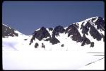
From Wood and Kienle (1990) [1] : "Mount Dana is a small calc-alkaline volcanic center consisting largely of volcaniclastic debris surrounding a central dome or domes, reminiscent of Augustine volcano. The volcano rests on relatively undeformed Jurassic and Cretaceous marine sandstone and shale. Mesozoic sedimentary rocks, dipping steeply southwest, form the southwest crater rim and are exposed in the canyon at the crater outlet. Remnants of a high-silica andesite dome are exposed on the west crater rim and in a small mound on the east side of Knutson Lake. A block-and-ash flow erupted 3,840 yBP fills valleys south and west of the crater. A 200-m-wide tufa mound and several cold springs occur at elevations of 490 to 520 m on the southwest flank."Name Origin
"Mount Dana" is a local name for this volcano, reported by the U.S. Geological Survey in 1929 (Orth, 1971).
References Cited
[1] Volcanoes of North America: United States and Canada, 1990
Wood, C. A., and Kienle, Juergen, (eds.), 1990, Volcanoes of North America: United States and Canada: New York, Cambridge University Press, 354 p.Reported Activity
Modern Eruptions
1 Event Date(s)
Past Activity Legend:
| Eruption | |
| Questionable eruption | |
| Non-eruptive activity |


Showing 1 - 10 of 10
Map Images
By:
U.S. Geological Survey
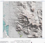
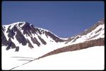
Topographic shaded relief map of Dana dome complex, Alaska.
Topographic shaded relief map of Dana dome complex, Alaska.
By:
Schaefer, J. R. G.
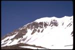
Alaska Peninsula volcanoes.
Alaska Peninsula volcanoes.
By:
Schaefer, Janet
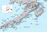
Index map showing the location of Quaternary volcanoes on the Alaska peninsula.
Index map showing the location of Quaternary volcanoes on the Alaska peninsula.
Map References
Volcanoes of Alaska, 1998
Nye, C. J., Queen, Katherine, and McCarthy, A. M., 1998, Volcanoes of Alaska: Alaska Division of Geological & Geophysical Surveys Information Circular IC 0038, unpaged, 1 sheet, scale 1:4,000,000, available at http://www.dggs.dnr.state.ak.us/pubs/pubs?reqtype=citation&ID=7043 .

Geologic map of the Port Moller, Stepovak Bay, and Simeonof Island quadrangles, Alaska Peninsula, Alaska, 1995
Wilson, F. H., Detterman, R. L., Miller, J. W., and Case, J. E., 1995, Geologic map of the Port Moller, Stepovak Bay, and Simeonof Island quadrangles, Alaska Peninsula, Alaska: U.S. Geological Survey Miscellaneous Investigations Series Map I 2272, unpaged, 2 sheets, scale 1:24,000.
Volcanoes of Alaska, 1995
Alaska Division of Geological & Geophysical Surveys, 1995, Volcanoes of Alaska: Alaska Division of Geological & Geophysical Surveys Information Circular IC 0038, unpaged, 1 sheet, scale 1:4,000,000.
Sample locality map and analytical data for potassium-argon ages in the Port Moller, Stepovak Bay, and Simeonof Island quadrangles, Alaska Peninsula, 1994
Wilson, F. H., Shew, Nora, DuBois, G. D., and Bie, S. W., 1994, Sample locality map and analytical data for potassium-argon ages in the Port Moller, Stepovak Bay, and Simeonof Island quadrangles, Alaska Peninsula: U.S. Geological Survey Miscellaneous Field Studies Map MF 2155-E, 18 p., 1 plate, scale 1:250,000.
Geothermal resources of the Aleutian Arc, 1993
Motyka, R. J., Liss, S. A., Nye, C. J., and Moorman, M. A., 1993, Geothermal resources of the Aleutian Arc: Alaska Division of Geological & Geophysical Surveys Professional Report PR 0114, 17 p., 4 sheets, scale 1:1,000,000.

Holocene volcanoes of the Aleutian Arc, Alaska, 1993
March, G. D., 1993, Holocene volcanoes of the Aleutian Arc, Alaska: Alaska Division of Geological & Geophysical Surveys Public-Data File PDF 93-85, unpaged, 1 sheet, scale 1:2,000,000.
Generalized geologic map of the Port Moller, Stepovak Bay, and Simeonof Island quadrangles, Alaska Peninsula, Alaska, 1991
Wilson, F. H., Detterman, R. L., and Harris, E. E., 1991, Generalized geologic map of the Port Moller, Stepovak Bay, and Simeonof Island quadrangles, Alaska Peninsula, Alaska: U.S. Geological Survey Miscellaneous Field Studies Map MF 2155-A, unpaged, 1 plate, scale 1:250,000.
Potassium-argon age determinations from the Port Moller and Stepovak Bay quadrangles, Alaska Peninsula, 1987
DuBois, G. D., Wilson, F. H., and Shew, N. B., 1987, Potassium-argon age determinations from the Port Moller and Stepovak Bay quadrangles, Alaska Peninsula: U.S. Geological Survey Open-File Report 87-0191, unpaged, 1 sheet, scale 1:250,000.
Map showing distribution, composition, and age of Late Cenozoic volcanic centers in Alaska, 1986
Luedke, R. G., and Smith, R. L., 1986, Map showing distribution, composition, and age of Late Cenozoic volcanic centers in Alaska: U.S. Geological Survey Miscellaneous Investigations Series Map I 1091-F, unpaged, 3 sheets, scale 1:1,000,000.
References
Proximity to active volcanoes enhances glacier velocity, 2024
Mallalieu, J., Barr, I.D., Spagnolo, M., Mullan, D.J., Symeonakis, E., Edwards, B.R., and Martin, M.D., 2024, Proximity to active volcanoes enhances glacier velocity: Communications Earth & Environment v. 5, 679. https://doi.org/10.1038/s43247-024-01826-5
Selected crater and small caldera lakes in Alaska: Characteristics and hazards, 2022
Waythomas, C.F., 2022, Selected crater and small caldera lakes in Alaska: Characteristics and hazards: Frontiers in Earth Science, v. 9, p. 23, doi:10.3389/feart.2021.751216.
Geologic database of information on volcanoes in Alaska (GeoDIVA), 2022
Cameron, C.E., Crass, S.W., and AVO Staff, eds, 2022, Geologic database of information on volcanoes in Alaska (GeoDIVA): Alaska Division of Geologic and Geophysical Surveys Digital Data Series 20, https://doi.org/10.14509/geodiva, https://doi.org/10.14509/30901.
Geochemistry of some Quaternary lavas from the Aleutian Arc and Mt. Wrangell, 2018
Nye, C.J., Beget, J.E., Layer, P.W., Mangan, M.T., McConnell, V.S., McGimsey, R.G., Miller, T.P., Moore, R.B., and Stelling, P.L., 2018, Geochemistry of some quaternary lavas from the Aleutian Arc and Mt. Wrangell: Alaska Division of Geological & Geophysical Surveys Raw Data File 2018-1, 29 p. http://doi.org/10.14509/29843
2018 update to the U.S. Geological Survey national volcanic threat assessment, 2018
Ewert, J.W., Diefenbach, A.K., and Ramsey, D.W., 2018, 2018 update to the U.S. Geological Survey national volcanic threat assessment: U.S. Geological Survey Scientific Investigations Report 2018-5140, 40 p., https://pubs.usgs.gov/sir/2018/5140/sir20185140.pdf.
Alaska Volcano Observatory image database, 2016
Cameron, C.E., and Snedigar, S.F., 2016, Alaska Volcano Observatory image database: Alaska Division of Geological & Geophysical Surveys Digital Data Series 13, https://www.avo.alaska.edu/images/. https://doi.org/10.14509/29689.
Preliminary database of Quaternary vents in Alaska, 2014
Cameron, C.E., and Nye, C.J., 2014, Preliminary database of Quaternary vents in Alaska: Alaska Division of Geological & Geophysical Surveys Miscellaneous Publication 153, 11 p., doi:10.14509/27357 .
Volcanoes of the world [3rd edition], 2010
Siebert, L., Simkim, T., and Kimberley, P., 2010, Volcanoes of the World [3rd edition]: Berkeley, University of California Press, 564 p.
Preliminary spreadsheet of eruption source parameters for volcanoes of the world, 2009
Mastin, L.G., Guffanti, Marianne, Ewert, J.E., and Spiegel, Jessica, 2009, Preliminary spreadsheet of eruption source parameters for volcanoes of the world: U.S. Geological Survey Open-File Report 2009-1133, v. 1.2, 25 p., available at http://pubs.usgs.gov/of/2009/1133/ .
System for ranking relative threats of U.S. volcanoes, 2007
Ewert, John, 2007, System for ranking relative threats of U.S. volcanoes: Natural Hazards Review, v. 8, n. 4, p. 112-124.

The National Volcano Early Warning System (NVEWS), 2006
Ewert, John, Guffanti, Marianne, Cervelli, Peter, and Quick, James, 2006, The National Volcano Early Warning System (NVEWS): U.S. Geological Survey Fact Sheet FS 2006-3142, 2 p., available at http://pubs.usgs.gov/fs/2006/3142 .
An assessment of volcanic threat and monitoring capabilities in the United States: framework for a National Volcano Early Warning System NVEWS, 2005
Ewert, J.W., Guffanti, Marianne, and Murray, T.L., 2005, An assessment of volcanic threat and monitoring capabilities in the United States: framework for a National Volcano Early Warning System NVEWS: U.S. Geological Survey Open-File Report 2005-1164, 62 p.

Volcanoes of the world: an illustrated catalog of Holocene volcanoes and their eruptions, 2003
Siebert, L., and Simkin, T., 2002-, Volcanoes of the world: an illustrated catalog of Holocene volcanoes and their eruptions: Smithsonian Institution, Global Volcanism Program Digital Information Series GVP-3, http://volcano.si.edu/search_volcano.cfm, unpaged internet resource.
Bibliography of information on Alaska volcanoes, 2003
Cameron, C. E., Triplehorn, J. H., and Robar, C. L., 2003, Bibliography of information on Alaska volcanoes: Alaska Division of Geological & Geophysical Surveys Miscellaneous Publication MP 131, 1 CD-ROM.
Hard Copy held by AVO at FBKS - CEC file cabinet
Volcanoes of Alaska, 1998
Nye, C. J., Queen, Katherine, and McCarthy, A. M., 1998, Volcanoes of Alaska: Alaska Division of Geological & Geophysical Surveys Information Circular IC 0038, unpaged, 1 sheet, scale 1:4,000,000, available at http://www.dggs.dnr.state.ak.us/pubs/pubs?reqtype=citation&ID=7043 .
Stratigraphic framework of the Alaska Peninsula, 1996
Detterman, R. L., Case, J. E., Miller, J. W., Wilson, F. H., and Yount, M. E., 1996, Stratigraphic framework of the Alaska Peninsula: U.S. Geological Survey Bulletin 1969-A, 74 p.

Geologic map of the Port Moller, Stepovak Bay, and Simeonof Island quadrangles, Alaska Peninsula, Alaska, 1995
Wilson, F. H., Detterman, R. L., Miller, J. W., and Case, J. E., 1995, Geologic map of the Port Moller, Stepovak Bay, and Simeonof Island quadrangles, Alaska Peninsula, Alaska: U.S. Geological Survey Miscellaneous Investigations Series Map I 2272, unpaged, 2 sheets, scale 1:24,000.
Volcanoes of Alaska, 1995
Alaska Division of Geological & Geophysical Surveys, 1995, Volcanoes of Alaska: Alaska Division of Geological & Geophysical Surveys Information Circular IC 0038, unpaged, 1 sheet, scale 1:4,000,000.
Sample locality map and analytical data for potassium-argon ages in the Port Moller, Stepovak Bay, and Simeonof Island quadrangles, Alaska Peninsula, 1994
Wilson, F. H., Shew, Nora, DuBois, G. D., and Bie, S. W., 1994, Sample locality map and analytical data for potassium-argon ages in the Port Moller, Stepovak Bay, and Simeonof Island quadrangles, Alaska Peninsula: U.S. Geological Survey Miscellaneous Field Studies Map MF 2155-E, 18 p., 1 plate, scale 1:250,000.
Volcanoes of the world [2nd edition], 1994
Simkin, Tom, and Siebert, Lee, 1994, Volcanoes of the world [2nd edition]: Tucson, Arizona, Geoscience Press, 349 p.
Hard Copy held by AVO at FBKS - CEC shelf
Quaternary volcanism in the Alaska Peninsula and Wrangell Mountains, Alaska, 1994
Miller, T. P., and Richter, D. H., 1994, Quaternary volcanism in the Alaska Peninsula and Wrangell Mountains, Alaska: in Plafker, George, Jones, D. L., and Berg, H. C., (eds.), The Geology of Alaska, Geological Society of America The Geology of North America series v. G-1, p. 759-779.
Hard Copy held by AVO at FBKS - CEC file cabinet
Geothermal resources of the Aleutian Arc, 1993
Motyka, R. J., Liss, S. A., Nye, C. J., and Moorman, M. A., 1993, Geothermal resources of the Aleutian Arc: Alaska Division of Geological & Geophysical Surveys Professional Report PR 0114, 17 p., 4 sheets, scale 1:1,000,000.
Holocene volcanoes of the Aleutian Arc, Alaska, 1993
March, G. D., 1993, Holocene volcanoes of the Aleutian Arc, Alaska: Alaska Division of Geological & Geophysical Surveys Public-Data File PDF 93-85, unpaged, 1 sheet, scale 1:2,000,000.
Generalized geologic map of the Port Moller, Stepovak Bay, and Simeonof Island quadrangles, Alaska Peninsula, Alaska, 1991
Wilson, F. H., Detterman, R. L., and Harris, E. E., 1991, Generalized geologic map of the Port Moller, Stepovak Bay, and Simeonof Island quadrangles, Alaska Peninsula, Alaska: U.S. Geological Survey Miscellaneous Field Studies Map MF 2155-A, unpaged, 1 plate, scale 1:250,000.
Volcanoes of North America: United States and Canada, 1990
Wood, C. A., and Kienle, Juergen, (eds.), 1990, Volcanoes of North America: United States and Canada: New York, Cambridge University Press, 354 p.
Hard Copy held by AVO at FBKS - CEC shelf
Potassium-argon age determinations from the Port Moller and Stepovak Bay quadrangles, Alaska Peninsula, 1987
DuBois, G. D., Wilson, F. H., and Shew, N. B., 1987, Potassium-argon age determinations from the Port Moller and Stepovak Bay quadrangles, Alaska Peninsula: U.S. Geological Survey Open-File Report 87-0191, unpaged, 1 sheet, scale 1:250,000.
Map showing distribution, composition, and age of Late Cenozoic volcanic centers in Alaska, 1986
Luedke, R. G., and Smith, R. L., 1986, Map showing distribution, composition, and age of Late Cenozoic volcanic centers in Alaska: U.S. Geological Survey Miscellaneous Investigations Series Map I 1091-F, unpaged, 3 sheets, scale 1:1,000,000.
Newly discovered Holocene volcanic vents. Port Moller and Stepovak Bay quadrangles, Alaska Peninsula, 1985
Yount, M. E., Wilson, F. H., and Miller, J. W., 1985, Newly discovered Holocene volcanic vents. Port Moller and Stepovak Bay quadrangles, Alaska Peninsula: in Bartsch-Winkler, Susan and Reed, K. M., (eds.), The United States Geological Survey in Alaska: accomplishments during 1983, U.S. Geological Survey Circular C 0945, p. 60-62.
Hard Copy held by AVO at FBKS - CEC file cabinet
The Aleutians, 1982
Marsh, B. D., 1982, The Aleutians: in Thorpe, R. S., (ed.), Andesites: orogenic andesites and related rocks, Chichester, United Kingdom, John Wiley & Sons, p. 99-114.
Hard Copy held by AVO at FBKS - CEC file cabinet
Volcanoes of the world, 1981
Simkin, Tom, Siebert, Lee, McClelland, Lindsay, Bridge, David, Newhall, Christopher, and Latter, J. H., 1981, Volcanoes of the world: Stroudsburg, PA, Hutchinson Publishing Company, 233 p.
Comprehensive tables giving physical data and thermal energy estimates for young igneous systems of the United States, 1978
Smith, R. L., Shaw, H. R., Luedke, R. G., and Russell, S. L., 1978, Comprehensive tables giving physical data and thermal energy estimates for young igneous systems of the United States: U.S. Geological Survey Open-File Report 78-0925, p. 1-25.
Hard Copy held by AVO at FBKS - CEC shelf
Alaska Peninsula-Aleutian Islands, 1958
Powers, H. A., 1958, Alaska Peninsula-Aleutian Islands: in Williams, H., (ed.), Landscapes of Alaska, Los Angeles, CA, University of California Press, p. 61-75.

My experiments with volcanoes, 1956
Jaggar, T.A., 1956, My experiments with volcanoes: Honolulu, Hawaiian Volcano Research Association, 198 p.
Volcanoes declare war: logistics and strategy of Pacific volcano science, 1945
Jaggar, T. A., 1945, Volcanoes declare war: logistics and strategy of Pacific volcano science: Honolulu, Paradise of the Pacific, Ltd, 166 p.
Mapping the home of the great brown bear: adventures of the National Geographic Society's Pavlof Volcano expedition to Alaska, 1929
Jaggar, T. A., 1929, Mapping the home of the great brown bear: adventures of the National Geographic Society's Pavlof Volcano expedition to Alaska: National Geographic Magazine, v. 55, p. 109-134.
Hard Copy held by AVO at FBKS - CEC file cabinet
The Pavlof volcano expedition, 1928
Wilson, R. M., 1928, The Pavlof volcano expedition: The Volcano Letter, v. 186, p. 1.
Past volcanic activity in the Aleutian arc,
Coats, R. R., Past volcanic activity in the Aleutian arc: U.S. Geological Survey Volcano Investigations Report 1, 18 p.

Before an eruption
Ashfall & Preparedness Information
- Ashfall impacts & preparedness (US Geological Survey)
- Volcanic health hazards & impacts (International Volcanic Health Hazards Network)
- Ash Alert! Pamphlet (AK Division of Homeland Security & Emergency Management)
- Volcanic Ashfall (AK Department of Environmental Conservation, Division of Air Quality)