Koniuji
Spurr
Great Sitkin
Akutan
Aniakchak
Atka volcanic complex
Augustine
Cleveland
Dutton
Edgecumbe
Fisher
Gareloi
Great Sitkin
Griggs
Iliamna
Isanotski
Kanaga
Katmai
Little Sitkin
Mageik
Makushin
Martin
Novarupta
Pavlof
Redoubt
Semisopochnoi
Shishaldin
Snowy
Spurr
Takawangha
Tanaga
Trident
Ugashik-Peulik
Ukinrek Maars
Veniaminof
Westdahl
Wrangell
Adagdak
Addington volcanic field
Alagogshak
Amak
Amchixtam Chaxsxii
Amukta
Andrew Bay volcano
Basalt of Gertrude Creek
Behm Canal-Rudyerd Bay
Black Peak
Blue Mtn
Bobrof
Bogoslof
Buldir
Buzzard Creek
Camille Cone
Capital
Carlisle
Chagulak
Chiginagak
Churchill, Mt
Cone 3110
Cone 3601
Dana
Davidof
Denison
Devils Desk
Double Glacier
Douglas
Drum
Duncan Canal
Emmons Lake Volcanic Center
Espenberg
Folsoms Bluff
Fourpeaked
Frosty
Gas Rocks, the
Gilbert
Gordon
Gosling Cone
Hayes
Herbert
Imuruk Lake Volc Field
Ingakslugwat Hills
Ingenstrem Depression Volcanic Field
Ingrisarak Mtn
Iron Trig cone
Iskut-Unuk River cones
Jarvis
Jumbo Dome
Kagamil
Kaguyak
Kasatochi
Kejulik
Kialagvik
Kiska
Klawasi Group
Knob 1000
Kochilagok Hill
Koniuji
Kookooligit Mountains
Koyuk-Buckland volcanics
Kukak
Kupreanof
Lone basalt
Maclaren River volcanic field
Moffett
Monogenetic QT vents of WWVF
Morzhovoi
Nelson Island
Nunivak Island
Nushkolik Mountain volcanic field
Okmok
Pavlof Sister
Prindle Volcano
Rainbow River cone
Recheshnoi
Roundtop
Sanford
Seguam
Segula
Sergief
Skookum Creek
St. George volcanic field
St. Michael
St. Paul Island
Steller
Stepovak Bay 1
Stepovak Bay 2
Stepovak Bay 3
Stepovak Bay 4
Suemez Island
Table Top Mtn
Tanada Peak
Tanax̂ Angunax̂
Tlevak Strait
Togiak volcanics
Trader Mtn
Uliaga
Ungulungwak Hill-Ingrichuak Hill
Unimak 5270
Unnamed (near Ukinrek Maars)
Vsevidof
Western Cones
Wide Bay cone
Yantarni
Yunaska
Legend
✕
| Red (Warning) | |
| Orange (Watch) | |
| Yellow (Advisory) | |
| Green (Normal) | |
| Uninstrumented | |
| Community | |
| Webcam | |
| Instrument | |
| Earthquake Magnitude | |
|
0
| |
| Earthquake Age | |
| Last 2 Hours | |
| Last 2 Days | |
| Last 1 Week | |
Facts
- Official Name: Koniuji Island
- Seismically Monitored: No
- Color Code: UNASSIGNED
- Alert Level: UNASSIGNED
- Elevation: 272m (892ft)
- Latitude: 52.22144
- Longitude: -175.13182
- Smithsonian VNum: 311140
- Pronunciation:
-
Nearby Towns:
- Atka 39 mi (64 km) SE
- Adak 68 mi (109 km) SW
- Nikolski 268 mi (431 km) NE
- Unalaska 375 mi (603 km) NE
- Saint George 377 mi (606 km) NE
Distance from Anchorage: 1130 mi (1818 km)

Description
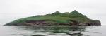
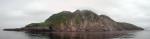
From Jicha (2009) [1] : Koniuji is a nascent stratovolcano, with 40Ar/39Ar ages that indicate subaerial lavas and domes erupted over the last 15,000 years, including at least three eruptions within the last 6000 years. It has an estimated volume of 1 cubic km, with approximately 25% of that volume subaerial. Dated products include older basaltic andesite lavas and younger andesite dome rocks.Wood and Kienle (1990) [2] note that in 1981, "geologists from the USGS research vessel S.P. Lee landed in a small boat to collect samples. The collected rocks are from andesite flows, and pyroclastic deposits. A northeast-trending fault cuts the island on the southeast. A possible vent occurs just north of the highest point on the island."
Name Origin
Koniuji Island is named for the great number of crested auks called "Kanoozkhi" or "Kanooskie" by the early Russians, and which the Unangax call "Kunuliuk." Lieutenant Sarichev published the name as "O[strov] Kanyugi" in 1826 (Orth, 1971).
References Cited
[1] Holocene volcanic activity at Koniuji Island, Aleutians, 2009
Jicha, B.R., 2009, Holocene volcanic activity at Koniuji Island, Aleutians: Journal of Volcanology and Geothermal Research, v. 185, n. 3, p. 214-222.[2] Volcanoes of North America: United States and Canada, 1990
Wood, C. A., and Kienle, Juergen, (eds.), 1990, Volcanoes of North America: United States and Canada: New York, Cambridge University Press, 354 p.Reported Activity
4 Event Date(s)
Past Activity Legend:
| Eruption | |
| Questionable eruption | |
| Non-eruptive activity |


Showing 1 - 6 of 6
Map Images
By:
U.S. Geological Survey
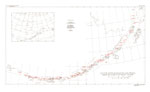
Topographic map of Kasatochi and Koniuji.
Topographic map of Kasatochi and Koniuji.
Map References
Volcanoes of Alaska, 1998
Nye, C. J., Queen, Katherine, and McCarthy, A. M., 1998, Volcanoes of Alaska: Alaska Division of Geological & Geophysical Surveys Information Circular IC 0038, unpaged, 1 sheet, scale 1:4,000,000, available at http://www.dggs.dnr.state.ak.us/pubs/pubs?reqtype=citation&ID=7043 .

Volcanoes of Alaska, 1995
Alaska Division of Geological & Geophysical Surveys, 1995, Volcanoes of Alaska: Alaska Division of Geological & Geophysical Surveys Information Circular IC 0038, unpaged, 1 sheet, scale 1:4,000,000.
Geothermal resources of the Aleutian Arc, 1993
Motyka, R. J., Liss, S. A., Nye, C. J., and Moorman, M. A., 1993, Geothermal resources of the Aleutian Arc: Alaska Division of Geological & Geophysical Surveys Professional Report PR 0114, 17 p., 4 sheets, scale 1:1,000,000.

Map showing distribution, composition, and age of Late Cenozoic volcanic centers in Alaska, 1986
Luedke, R. G., and Smith, R. L., 1986, Map showing distribution, composition, and age of Late Cenozoic volcanic centers in Alaska: U.S. Geological Survey Miscellaneous Investigations Series Map I 1091-F, unpaged, 3 sheets, scale 1:1,000,000.
Volcanic activity in the Aleutian Arc, 1950
Coats, R. R., 1950, Volcanic activity in the Aleutian Arc: U.S. Geological Survey Bulletin 0974-B, p. 35-49, 1 sheet, scale 1:5,000,000.
Reconnaissance of the gold fields of southern Alaska with some notes on general geology, 1898
Becker, G. F., 1898, Reconnaissance of the gold fields of southern Alaska with some notes on general geology: U.S. Geological Survey Annual Report 0018, p. 1-86, 6 sheets, scale unknown.
References
Geologic database of information on volcanoes in Alaska (GeoDIVA), 2022
Cameron, C.E., Crass, S.W., and AVO Staff, eds, 2022, Geologic database of information on volcanoes in Alaska (GeoDIVA): Alaska Division of Geologic and Geophysical Surveys Digital Data Series 20, https://doi.org/10.14509/geodiva, https://doi.org/10.14509/30901.
2018 update to the U.S. Geological Survey national volcanic threat assessment, 2018
Ewert, J.W., Diefenbach, A.K., and Ramsey, D.W., 2018, 2018 update to the U.S. Geological Survey national volcanic threat assessment: U.S. Geological Survey Scientific Investigations Report 2018-5140, 40 p., https://pubs.usgs.gov/sir/2018/5140/sir20185140.pdf.
Alaska Volcano Observatory image database, 2016
Cameron, C.E., and Snedigar, S.F., 2016, Alaska Volcano Observatory image database: Alaska Division of Geological & Geophysical Surveys Digital Data Series 13, https://www.avo.alaska.edu/images/. https://doi.org/10.14509/29689.
Preliminary database of Quaternary vents in Alaska, 2014
Cameron, C.E., and Nye, C.J., 2014, Preliminary database of Quaternary vents in Alaska: Alaska Division of Geological & Geophysical Surveys Miscellaneous Publication 153, 11 p., doi:10.14509/27357 .
Volcanoes of the world [3rd edition], 2010
Siebert, L., Simkim, T., and Kimberley, P., 2010, Volcanoes of the World [3rd edition]: Berkeley, University of California Press, 564 p.
An "inactive stratovolcano that erupted ~3000 years ago: Koniuji Island, Aleutians, 2009
Jicha, B.R., and Singer, B.S., 2009, An "inactive stratovolcano that erupted ~3000 years ago: Koniuji Island, Aleutians [abs.]: Scientific Program and Abstracts, 6th Biennial workshop on Japan-Kamchatka-Alaska Subduction Processes (JKASP-2009), June 22-26, 2009, Fairbanks, AK.
Holocene volcanic activity at Koniuji Island, Aleutians, 2009
Jicha, B.R., 2009, Holocene volcanic activity at Koniuji Island, Aleutians: Journal of Volcanology and Geothermal Research, v. 185, n. 3, p. 214-222.
Preliminary spreadsheet of eruption source parameters for volcanoes of the world, 2009
Mastin, L.G., Guffanti, Marianne, Ewert, J.E., and Spiegel, Jessica, 2009, Preliminary spreadsheet of eruption source parameters for volcanoes of the world: U.S. Geological Survey Open-File Report 2009-1133, v. 1.2, 25 p., available at http://pubs.usgs.gov/of/2009/1133/ .
Biological monitoring in the central Aleutian Island, Alaska, in 2008: summary appendices, 2008
Buchheit, R.M., and Ford, J.C., 2008, Biological monitoring in the central Aleutian Islands, Alaska in 2008: summary appendices: U.S. Fish and Wildlife Service Report, AMNWR 08/12, Homer, AK, 141 p.
System for ranking relative threats of U.S. volcanoes, 2007
Ewert, John, 2007, System for ranking relative threats of U.S. volcanoes: Natural Hazards Review, v. 8, n. 4, p. 112-124.

Volcanoes of the world: an illustrated catalog of Holocene volcanoes and their eruptions, 2003
Siebert, L., and Simkin, T., 2002-, Volcanoes of the world: an illustrated catalog of Holocene volcanoes and their eruptions: Smithsonian Institution, Global Volcanism Program Digital Information Series GVP-3, http://volcano.si.edu/search_volcano.cfm, unpaged internet resource.
Bibliography of information on Alaska volcanoes, 2003
Cameron, C. E., Triplehorn, J. H., and Robar, C. L., 2003, Bibliography of information on Alaska volcanoes: Alaska Division of Geological & Geophysical Surveys Miscellaneous Publication MP 131, 1 CD-ROM.
Hard Copy held by AVO at FBKS - CEC file cabinet
Volcanoes of Alaska, 1998
Nye, C. J., Queen, Katherine, and McCarthy, A. M., 1998, Volcanoes of Alaska: Alaska Division of Geological & Geophysical Surveys Information Circular IC 0038, unpaged, 1 sheet, scale 1:4,000,000, available at http://www.dggs.dnr.state.ak.us/pubs/pubs?reqtype=citation&ID=7043 .
Volcanoes of Alaska, 1995
Alaska Division of Geological & Geophysical Surveys, 1995, Volcanoes of Alaska: Alaska Division of Geological & Geophysical Surveys Information Circular IC 0038, unpaged, 1 sheet, scale 1:4,000,000.
Geologic framework of the Aleutian arc, Alaska, 1994
Vallier, T. L., Scholl, D. W., Fisher, M. A., Bruns, T. R., Wilson, F. H., von Huene, Roland, and Stevenson, A. J., 1994, Geologic framework of the Aleutian arc, Alaska: in Plafker, George and Berg, H. C., (eds.), The Geology of Alaska, Geological Society of America The Geology of North America series v. G-1, p. 367-388.
Hard Copy held by AVO at FBKS - CEC file cabinet
Volcanoes of the world [2nd edition], 1994
Simkin, Tom, and Siebert, Lee, 1994, Volcanoes of the world [2nd edition]: Tucson, Arizona, Geoscience Press, 349 p.
Hard Copy held by AVO at FBKS - CEC shelf
Age, character, and significance of Aleutian arc volcanism, 1994
Fournelle, J. H., Marsh, B. D., and Myers, J. D., 1994, Age, character, and significance of Aleutian arc volcanism: in Plafker, George and Berg, H. C., (eds.), The Geology of Alaska, Geological Society of America The Geology of North America Series v. G-1, p. 723-758.
Aleut dictionary, Unangam Tunudgusii, an unabridged lexicon of the Aleutian, Pribilof, and Commander Islands Aleut language, 1994
Bergsland, Knut, comp., 1994, Aleut dictionary, Unangam Tunudgusii, an unabridged lexicon of the Aleutian, Pribilof, and Commander Islands Aleut language: University of Alaska Fairbanks, Alaska Native Language Center, 739 p.
Geothermal resources of the Aleutian Arc, 1993
Motyka, R. J., Liss, S. A., Nye, C. J., and Moorman, M. A., 1993, Geothermal resources of the Aleutian Arc: Alaska Division of Geological & Geophysical Surveys Professional Report PR 0114, 17 p., 4 sheets, scale 1:1,000,000.
Volcanoes of North America: United States and Canada, 1990
Wood, C. A., and Kienle, Juergen, (eds.), 1990, Volcanoes of North America: United States and Canada: New York, Cambridge University Press, 354 p.
Hard Copy held by AVO at FBKS - CEC shelf
Map showing distribution, composition, and age of Late Cenozoic volcanic centers in Alaska, 1986
Luedke, R. G., and Smith, R. L., 1986, Map showing distribution, composition, and age of Late Cenozoic volcanic centers in Alaska: U.S. Geological Survey Miscellaneous Investigations Series Map I 1091-F, unpaged, 3 sheets, scale 1:1,000,000.
The Aleutians, 1982
Marsh, B. D., 1982, The Aleutians: in Thorpe, R. S., (ed.), Andesites: orogenic andesites and related rocks, Chichester, United Kingdom, John Wiley & Sons, p. 99-114.
Hard Copy held by AVO at FBKS - CEC file cabinet
Comprehensive tables giving physical data and thermal energy estimates for young igneous systems of the United States, 1978
Smith, R. L., Shaw, H. R., Luedke, R. G., and Russell, S. L., 1978, Comprehensive tables giving physical data and thermal energy estimates for young igneous systems of the United States: U.S. Geological Survey Open-File Report 78-0925, p. 1-25.
Hard Copy held by AVO at FBKS - CEC shelf
Alaska Peninsula-Aleutian Islands, 1958
Powers, H. A., 1958, Alaska Peninsula-Aleutian Islands: in Williams, H., (ed.), Landscapes of Alaska, Los Angeles, CA, University of California Press, p. 61-75.

Volcano observations, 1954
Unknown, 1954, Volcano observations: Unpublished volcano observation sheets filled out by U.S. military and stored on file at the Geophyiscal Institute, University of Alaska Fairbanks, unpaged.
Hard Copy held by AVO at FBKS - CEC file cabinet
Volcanic activity in the Aleutian Arc, 1950
Coats, R. R., 1950, Volcanic activity in the Aleutian Arc: U.S. Geological Survey Bulletin 0974-B, p. 35-49, 1 sheet, scale 1:5,000,000.
United States coast pilot, Alaska Part 2, Yakutat Bay to Arctic Ocean, 1947
U.S. Department of Commerce, and Coast and Geodetic Survey, 1947, United States coast pilot, Alaska Part 2, Yakutat Bay to Arctic Ocean: Washington DC, United States Government Printing Office, 659 p.
Katalog der geschichtlichen vulkanausbruche, 1917
Sapper, Karl, 1917, Katalog der geschichtlichen vulkanausbruche: Strassburg, Germany, Karl J. Trubner, 358 p.

Reported volcanic eruptions in Alaska, Puget Sound, etc., 1690-1896, 1898
Plummer, F. G., 1898, Reported volcanic eruptions in Alaska, Puget Sound, etc., 1690-1896: in Holden, E. S., (ed.), A Catalogue of Earthquakes on the Pacific Coast 1769-1897, Smithsonian Institution Miscellaneous Collections 1087, City of Washington D.C., Smithsonian Institution, p. 24-27.

Reconnaissance of the gold fields of southern Alaska with some notes on general geology, 1898
Becker, G. F., 1898, Reconnaissance of the gold fields of southern Alaska with some notes on general geology: U.S. Geological Survey Annual Report 0018, p. 1-86, 6 sheets, scale unknown.
Alaska and its resources, 1870
Dall, W. H., 1870, Alaska and its resources: Boston, Lee and Shepard, 627 p.
Grewingk's geology of Alaska and the Northwest Coast of America [edited by Marvin W. Falk, translation by Fritz Jaensch published 2003], 1850
Grewingk, Constantine, 1850, Grewingk's geology of Alaska and the Northwest Coast of America [edited by Marvin W. Falk, translation by Fritz Jaensch published 2003]: Rasmuson Library Historical Translation Series 11, Fairbanks, AK, The University of Alaska Press, 242 p.
Hard Copy held by AVO at FBKS - CEC shelf
Past volcanic activity in the Aleutian arc,
Coats, R. R., Past volcanic activity in the Aleutian arc: U.S. Geological Survey Volcano Investigations Report 1, 18 p.

Before an eruption
Ashfall & Preparedness Information
- Ashfall impacts & preparedness (US Geological Survey)
- Volcanic health hazards & impacts (International Volcanic Health Hazards Network)
- Ash Alert! Pamphlet (AK Division of Homeland Security & Emergency Management)
- Volcanic Ashfall (AK Department of Environmental Conservation, Division of Air Quality)